bob_m
Active member
I had a presentation I needed to give in Spokane. It is only 343 miles by the shortest route, so rather than fly I opted to ride and take a couple of vacation days on each end of the Wednesday event for travel. I did not take the shortest route. Having ridden the Columbia River Gorge innumerable times, I simply went on the interstate to Hwy 97, and crossed over to the Washington side to ride a two lane route to Kenniwick. From there I took hwy 12 through the rolling wheat farming region of the Palouse to Colfax. The grain crops were lush green and the undulating terrain was cloaked in green velvet. Hit one short rain squall just south of Spokane, just enough to rinse the bugs off my face shield. The event was over at about 4:00 so I packed up and rode east and then south on Hwy 95. This route parallels the massive mountain lake of Coeur De Lane then wends its way through a transition zone between the Palouse and the Rocky Mt. foothills. In the valleys the ride was surrounded by the tall luxuriant wheat, and then the road would climb a foothill ridge through pines to a view of the agricultural richness below; repeat. As I neared Lewiston I saw a sign that read “Frontage Road, Scenic Viewpoint”. What I found was that I had been meandering across a high plateau and that the “frontage road” looped and twisted down the face of the Snake River gorge. The drop was about 1500’. At first tar snakes heightened my pucker factor, but further down the cliff face the pavement got better and I assumed my cautious but enthusiastic pace. I camped at Hell’s Gate State Park on a branch of the dammed Snake River. With a beer in hand, as I walked along the water's edge at twilight, I saw a large owl fly by.
After food and fuel I headed south over Hwy 129 from Clarkston to Enterprise. This is Rattlesnake Pass. The road is beautiful, twisty and remote, running down to the Grande Ronde River near the Snake in Hell’s Canyon. It is really big country. Again I assumed my “old man’s” enthusiastic pace which I am sure would be laughable to more courageous riders. On the Oregon side, I stopped for a few minutes to watch a Golden Eagle soaring just overhead. My first positive I.D. of that awesome bird.
The ride from there was pretty much a run back to the barn. I rested for a bit on a pic nic table near Umatilla, and woke up to find the heat had dissipated from the engine. The wind between La Grande and Troutdale was strong and gusty. That made the ride frenetic. My 1982 R100RS ran flawlessly. The presentation went well.
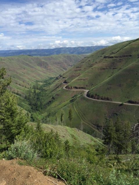
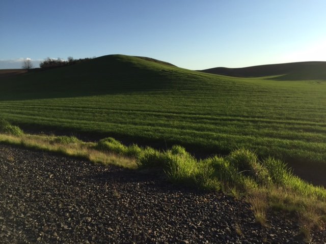
Photos are of Hwy 3 north of Enterprise, and a Palouse hill in the late afternoon. Look for the car on the Hwy 3 photo to appreciate the scale of the canyon.
After food and fuel I headed south over Hwy 129 from Clarkston to Enterprise. This is Rattlesnake Pass. The road is beautiful, twisty and remote, running down to the Grande Ronde River near the Snake in Hell’s Canyon. It is really big country. Again I assumed my “old man’s” enthusiastic pace which I am sure would be laughable to more courageous riders. On the Oregon side, I stopped for a few minutes to watch a Golden Eagle soaring just overhead. My first positive I.D. of that awesome bird.
The ride from there was pretty much a run back to the barn. I rested for a bit on a pic nic table near Umatilla, and woke up to find the heat had dissipated from the engine. The wind between La Grande and Troutdale was strong and gusty. That made the ride frenetic. My 1982 R100RS ran flawlessly. The presentation went well.
Photos are of Hwy 3 north of Enterprise, and a Palouse hill in the late afternoon. Look for the car on the Hwy 3 photo to appreciate the scale of the canyon.
Attachments
Last edited: