•  

    Welcome! You are currently logged out of the forum. Some forum content will be hidden from you if you remain logged out. If you want to view all content, please LOG IN!

    If you are not an MOA member, why not take the time to join the club, so you can enjoy posting on the forum, the BMW Owners News magazine, and all of the benefits of membership? If you click here, you have the opportunity to take us for a test ride at our expense. Enter the code 'FORUM25' in the activation code box to try the first year of the MOA on us!


New BMW Connected Ride Navigator

No issues using it with my Cardo PackTalk bold and iPhone 14
Sena with an iPhone 12 Mini. No issues. You have to connect them to the bike. I've had good luck creating an Automation on my iPhone that automatically opens the Connected app when it connects to my bike.

I wish it had volume control for my Sena, but I can deal. I wish it had a bit better ability to control Apple Music playlists and could browse my Apple Music app instead of just downloaded playlists.

But it's fine. The nav is fine if I'm following a track or something, but yeah, the legends can be tiny, especially on my phone, a Mini.
 
Works fine with my Cardo pak talk and samsung phone . $745 paid for new unit from my dealer plus tax .

Dont like the app as it tells me service is due by millage , but date follows what I set with GS911 .
 
It took me some time to get used t this (just bought the bike/ brand, 2023 R18TC). Aside from the process of opening the map display on the phone first, then waiting for it to broadcast onto the TFT screen (could be user caused..), it's been pretty much hassle free. I've been using google maps and My route app to create GPX files, then downloading them into the connectedride app.
 
If anyone is looking for an easy way to create GPX files and get them on your iPhone, I've been using https://www.gpsvisualizer.com/convert?output to convert maps I draw in Google Maps to GPX. From there, I can airdrop them to my phone from my Mac and import them into the Ride App.

You'll need to get a Google API key from to allow GPS Visualizer to read the website and convert it, but once that's done, it takes just about no time to make a route and import it.

And, the biggest bonus of all, you don't have to use Garmin's janky products to make the route. That means you can use drag and drop, you can use Google's search functions to find destinations and the like.

If anyone is interested, I can make a thread and show how.
 
I went for a ride…and discovered the following problems:

When I switched the speedometer display to mph from km/hr the multi-controller stopped controlling the crn.
The menu button stopped working to switch control between the crn and the tft.
After I switched the tft back to km/hr, then turned the bike off..everything returned to normal…but then every once in a while the crn would stop responding to the multi-controller for an hour or so…then just as suddenly the crn would resume normal operation.
I have “avoid unpaved roads” selected in the navigation preferences…despite this the navigator took me down gravel roads, or tried to take me down gravel roads several times.

I went to the dealer today who told me to bring the bike in to see if the bike needed a firmware update.
 
If anyone is looking for an easy way to create GPX files and get them on your iPhone, I've been using https://www.gpsvisualizer.com/convert?output to convert maps I draw in Google Maps to GPX. From there, I can airdrop them to my phone from my Mac and import them into the Ride App.

You'll need to get a Google API key from to allow GPS Visualizer to read the website and convert it, but once that's done, it takes just about no time to make a route and import it.

And, the biggest bonus of all, you don't have to use Garmin's janky products to make the route. That means you can use drag and drop, you can use Google's search functions to find destinations and the like.

If anyone is interested, I can make a thread and show how.
I'm very interested in seeing this process. I'm a basecamp fan, but I understand Garmin will not be supporting the software much longer so options are always good.
 
I'm very interested in seeing this process. I'm a basecamp fan, but I understand Garmin will not be supporting the software much longer so options are always good.
I'll try and put something together. It's pretty easy once you have the Google API key.
 
This is my first post. I picked up my S1000R on Tuesday and have been thinking about navigation a lot. The S1000R has the smaller TFT display and really does not show both navigation and the regular display at the same time. I wanted to be able to see the navigation all the time which meant something like the Zumo XT2, TomTom or other similar unit, or the full BMW solution. After a lot of thinking, I went with the BMW solution, it seemed the simplest way to go even though it was the most expensive.

My problem/question is route planning. There are several options to get a GPX file to load onto the BMW system from what I can see, but I don't see a good solution for creating maps. People have commented about the Garmin Basecamp going away eventually. My issue is that it is not supported very well on newer Mac silicon which means I can use it. I have tried the TomTom route planning software which is not bad. TomTom also has an iPad/iPhone planning software but it has limitations too. Most allow you to say whether to avoid highways, dirt roads etc. Many also let you choose if you want to give priority to roads with lots of turns. All of this is great until you want to change something because a road is closed or is no longner paved after 10 miles, etc. Some software tries to reroute the entire route if you drag one line to go around something.

What are people using for their route planning software, and what is the process of getting the route to whatever they are using on their bikes?
 
What are people using for their route planning software, and what is the process of getting the route to whatever they are using on their bikes?

Basecamp. It's FAR from easy/user friendly, but, it works every single time and now that I know it well enough, I can very quickly build a route and have pretty good confidence my GPS will follow it exactly as I intended. I've not found anything as good/fast for getting routes to a Garmin device.

For quick rides, I just use Google maps. But for longer, more involved routes or those that I ride often, I spend the time to build them in Basecamp.
Thanks will Basecamp output a GPX for the BMW system or do you use something like Maps to GPX?
 
Thanks will Basecamp output a GPX for the BMW system or do you use something like Maps to GPX?

You can output a GPX from Basecamp. If you have the BMW Garmin (Nav 6), it's dead simple. If you just want the GPX of the route (or track), that's doable to, and you could then import it into any navigator that takes a GPX format. I've only done that a few times (to get routes onto my road bike GPS before I got a Garmin Edge), but I know it's doable (and wasn't a terrible process, like everything Basecamp, it took me some head scratching I'm sure!).
 
BMW should have created an Apple Car Play device like Chigee. I absolutely hate the Connected Ride System, App, navigator, all of it. It just does not work or you have to be Stephen Hawking to decider the way to get gpx files into it. $800 wasted. Great motorcycles, terrible peripherals.
 
You can output a GPX from Basecamp. If you have the BMW Garmin (Nav 6), it's dead simple. If you just want the GPX of the route (or track), that's doable to, and you could then import it into any navigator that takes a GPX format. I've only done that a few times (to get routes onto my road bike GPS before I got a Garmin Edge), but I know it's doable (and wasn't a terrible process, like everything Basecamp, it took me some head scratching I'm sure!).
I have discovered, with the help of a fellow BMW rider from Georgia, that Basecamp creates a .gpx file that is compatible with Garmin products. The CRN is TomTom compatible. If you output a .gpx file from Basecamp it needs to be converted to TomTom format, specifically .gpx 1.1
I use MyRoute-App to accomplish this conversion. During the conversion there is the opportunity to add your choice of POI’s.
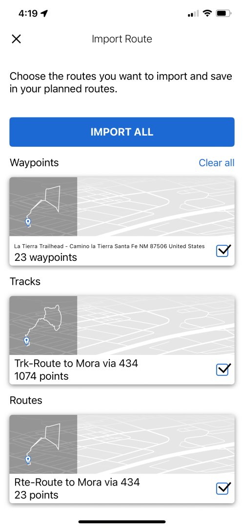
When importing the resulting file using the Connected Ride App there is the choice of importing either the Route or the Track - The track will have a plethora of waypoints, the route will have far fewer. The key to this process is to import the files individually - importing the files en masse will remove the choice of route or track.
I am not using basecamp since it does not seem to even recognize my ConnecedRide Navigator. I am using InRoute and am very pleased with it. I also outputs a GPX file. What I attached below is an image of what the connected ride app. does when you want to import. In my case I pointed it to the GPX file inRoute exported to a folder I created on my iCloud drive called "maps". It seems like the connected ride app creates three different files when you tell it to open the file (in my case on my iPhone). As others have mentioned some have fewer and some have a lot more points. As a test, I only imported the file with a lot of points (1074 in this case). Once it is imported I had to restart the connected ride app twice before it synced the single file I imported and made it available to my connected ride navigator. One of the things I liked about the inRide app, and I know basecamp can do this too, is that you can define in inRoute whether each pin you use to shape the routes is a stop or a via. If it is a via, you won't have to stop at the point to continue. The map I imported from the list below is what I just used for about a 230 mile trip I just got back from. It worked flawlessly. The process to get to this point should be for BMW quite embarrassing.
BMW should have created an Apple Car Play device like Chigee. I absolutely hate the Connected Ride System, App, navigator, all of it. It just does not work or you have to be Stephen Hawking to decider the way to get gpx files into it. $800 wasted. Great motorcycles, terrible peripherals.
I might agree with you but where I live you need a satellite not a cellular based system. Cellular service is not existent in many places.
 

Attachments

  • IMG_B4143B8189DB-1.jpeg
    IMG_B4143B8189DB-1.jpeg
    900.2 KB · Views: 110
I have another question. I want to use the magic wheel to control the map as has been documented by lots of folks. I have a 2024 S1000R. I had the dealer install everything and the ConnectedRide Navigator most works. I does horrible and sketchy documentation. What I want to do is change the focus of the magic wheel to the Navigator and back to the TFT. The on line reference states:


Article​

Viewed by 1605 visitors1605

During the journey: How to switch the multicontroller operation from the TFT display to the ConnectedRide Navigator?​

Press and hold the Menu button on the top of your handlebars.
The TFT display then shows "NAV" in the top left-hand corner (instead of the word "TFT").
---------

Does this work for others with the same/similar bike with the new ConnectedRide Navigator?
 
I have another question. I want to use the magic wheel to control the map as has been documented by lots of folks. I have a 2024 S1000R. I had the dealer install everything and the ConnectedRide Navigator most works. I does horrible and sketchy documentation. What I want to do is change the focus of the magic wheel to the Navigator and back to the TFT. The on line reference states:

Article​

Viewed by 1605 visitors1605

During the journey: How to switch the multicontroller operation from the TFT display to the ConnectedRide Navigator?​

Press and hold the Menu button on the top of your handlebars.
The TFT display then shows "NAV" in the top left-hand corner (instead of the word "TFT").
---------

Does this work for others with the same/similar bike with the new ConnectedRide Navigator?
A short press down on the menu button…and a long press up on the menu button will change it - and I have to be on the bike to remember which way round it is..
 

Article​

Viewed by 1605 visitors1605

During the journey: How to switch the multicontroller operation from the TFT display to the ConnectedRide Navigator?​

Press and hold the Menu button on the top of your handlebars.
The TFT display then shows "NAV" in the top left-hand corner (instead of the word "TFT").
Same setup on a Wethead with a BMW Navigator V or VI with GPS Prep.
 
Same setup on a Wethead with a BMW Navigator V or VI with GPS Prep.

I have tried all this and nothing works. I am having an oil/radiator guard installed at the dealer this week. They did the original installation. I willl ask them to check it out.
 
I’m considering the Connected Ride Nav but I’m not really convinced. I’m seeing positive reviews of the Chigee AIO-5 for BMW, but I can’t find out anything about who they are. Does anyone know who they are, where they are based, where manufactured etc? Their website ‘about us’ page is just marketing talk.
 
I’m considering the Connected Ride Nav but I’m not really convinced. I’m seeing positive reviews of the Chigee AIO-5 for BMW, but I can’t find out anything about who they are. Does anyone know who they are, where they are based, where manufactured etc? Their website ‘about us’ page is just marketing talk.

They are Chinese. I have one and it works great so far.
 
Back
Top