• Welcome, Guest! We hope you enjoy the excellent technical knowledge, event information and discussions that the BMW MOA forum provides. Some forum content will be hidden from you if you remain logged out. If you want to view all content, please click the 'Log in' button above and enter your BMW MOA username and password.

    If you are not an MOA member, why not take the time to join the club, so you can enjoy posting on the forum, the BMW Owners News magazine, and all of the discounts and benefits the BMW MOA offers?

  • Beginning April 1st, and running through April 30th, there is a new 2024 BMW MOA Election discussion area within The Club section of the forum. Within this forum area is also a sticky post that provides the ground rules for participating in the Election forum area. Also, the candidates statements are provided. Please read before joining the conversation, because the rules are very specific to maintain civility.

    The Election forum is here: Election Forum

Basecamp & Nav V

Furman

Manic Mechanic
I have been doing routes on Basecamp and downloading into my GPS for a while now, without much of an issue. But now I have one. Made my route on Basecamp (a little over 400 miles) I used 29 waypoints to make my route. Down loaded into BMW Navigator V. So far so good. Open trips on the Nav. V and imported the route. Nav. V informs that there are to many via points and will have to divide the route into three separate routes. Never had that before. So I took out all the waypoints except for start and end. Download it into the Nav V, same message. After reading some help files I found I could change the via point count. I set it to automatic and the slider to minimum way points. Still the same results. Try only 10 via points, same thing.

Is there a way to change this route so it will not be broken up into three routes?

Thanks for the help.
 
I use a similar zümo 590 so I don't think you should be having this problem. Dan Townsley wrote a review of the Navigator V stating that it allows 30 via points per route with up to 125 shaping points between any two via points. The article is here, the reference is almost halfway down under his discussion of the Trip Planner app.

In any discussion of route planning, there is sometimes confusion about terms used for the different types of points. Dan does not use the term waypoint in the article, so I'll use his terminology. As he uses them in the article, the allowance of 30 points include the start, end, and intermediate via points. These thirty are the points announced by the GPS as you approach. The 28 intermediate stops might be for lunch or gas. When you begin a route, you can navigate directly to an intermediate via point, bypassing any previous points from the original calculation. Shaping points are used to force the route calculation to use the roads of your choice. These are not announced by the GPS as you approach or arrive. The trip computer will show the distance/time to the next via point, but not the next shaping point. If you are off route, recalculations are done to the next via point, not the next shaping point.

If you double-click to open your route in Basecamp, the text listing of your points will show shaping points slightly grayed out with "(won't alert)" after the point name. Intermediate via points can be changed to shaping points by right-clicking the point and selecting "Don't alert on arrival (shaping point)".

If you know all this, I'll apologize for wasting your time, but I just wanted to establish a base for discussion. And nobody else has responded, so I'll take a stab at it.

I think the original problem with your route might be the total number of points - start+end +29 "waypoints"=31 via points? I suspect that some of your "waypoints" could be converted to shaping points to reduce the total number of via points. I would not convert all of the intermediate points, as more via points provide more options when starting out and in the event of recalculation.)

Any chance your second/third /... attempts are reading an earlier version? Be sure to delete all trace from the internal memory via the GPS and anything on the SD card.

I am surprised that the GPS is splitting your original route into three parts. I'd think that two would be enough to accommodate the via point limits.


Or there is something else entirely going on here...:dunno
 
Looks like a fun ride.
First thing I noticed is that you don't have either a motorcycle or Automobile profile selected.
That might be part of your problem.
Double click the route and the dialog box will open.
Upper right of the box...see that little man next to the route color selector?
You need to change him to a motorcycle. ;-)

I also see other minor issues with your route.
Many of your waypoints and shaping points are set to "alert". Your GPS is going to be talking to you a lot.

Good luck.

Joe
 
Sorry that was the wrong one. This is the correct one.
 

Attachments

  • BRPR18Long.gpx
    604 KB · Views: 168
Opening Home to BRPR 18Long.gpx in Basecamp, I'm counting 69 intermediate via points, plus the start and end points, so I now understand why the Nav V had to split it into three routes. My zümo did the same thing.

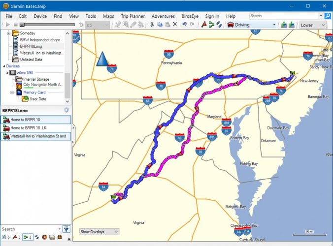
I've edited it a bit, changing many of the via points to shaping points. You seldom need to hear nine times that you are approaching another spot on I-76, for example. A few points I shifted a little. One looked to be on road parallel to a highway, taking you off and back on the main road. A couple were very near exit ramps, and my experience has been that small uncertainties in your exact position here can lead the GPS to direct you off the highway unintentionally. A few via points I renamed, so that the announcement is more meaningful. "Approaching Parkway" is the last point before you turn onto the Blue Ridge Parkway, "Potomac River" is at the bridge, etc. It's down to ten via points now, with 61 shaping points. If you intended to stop at a particular point for some reason, make sure I did not change it to a shaping point if you want it to be announced. I've loaded the modified route into my zümo without problems, and it still matches your original route when loaded back into Basecamp.

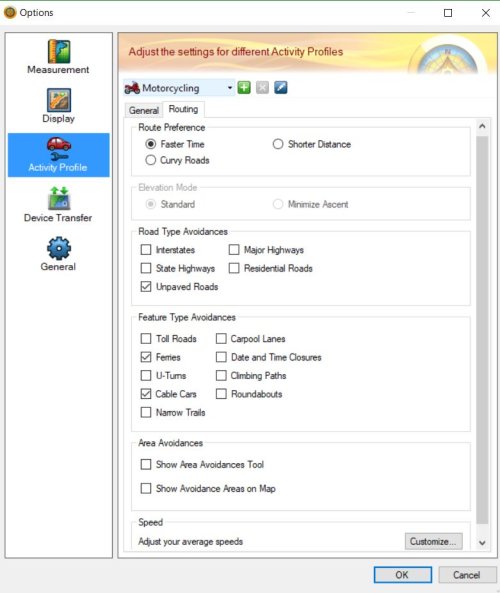
Personally, I don't use the Motorcycle profile if I'm planning a route in advance and choosing the roads I want to use. It routes me on slow residential streets through towns when I'd rather continue on the faster state route and introduces strange diversions that don't further my progress and often aren't much fun to ride. Unless I use a large amount of points to restrict the route, the GPS (in MC profile) further changes the route adding even more diversions, so the route ends up very different from my original plan. Using Driving profile in Basecamp and the GPS seems to be more predictable for picking your own roads. Motorcycle mode seems better suited to finding a random route when you just want to know you will eventually reach your destination and don't care when or how you arrive. I've used it successfully a couple times on day rides when it became clear my planned route was too ambitious, and I wanted to head home, but still wanted to stay off the interstates.

Wattstull Inn to Washington St and Swayze Ave.gpx gave me a very different route and direction from Home to BRPR 18Long.gpx, both in Basecamp and on the zümo, regardless of the profile used. It might be a little too cleaned up.

Capture.jpg

EDIT: I included a track of the same route in the .gpx file. I find it helpful to display the track with the route in case the route calculated by the GPS differs from the original planned in Basecamp. The track will appear as a black border on to the magenta track. If the two diverge, you will see the borderless route and can zoom out to find the black track to decide if/how you want to get back on the original plan.
 

Attachments

  • Modified BRPR18Long.gpx
    951.9 KB · Views: 165
Any profile in Basecamp needs to be configured to be useful. For example, the Speed section at the bottom will change road selection dramatically.

basecamp.jpg
 
Back
Top