•  

    Welcome! You are currently logged out of the forum. Some forum content will be hidden from you if you remain logged out. If you want to view all content, please LOG IN!

    If you are not an MOA member, why not take the time to join the club, so you can enjoy posting on the forum, the BMW Owners News magazine, and all of the benefits of membership? If you click here, you have the opportunity to take us for a test ride at our expense. Enter the code 'FORUM25' in the activation code box to try the first year of the MOA on us!


West from Thunder Bay Ontario- a fork in the road?

dogsbody

New member
I am starting to look at routes to and from next years national rally at Hamburg NY. I was thinking of returning to Washington State mostly on the Trans Canada Highway. West of Thunder Bay Highway 11 and 17 are both part of the TCH. Is there reason to choose one over the other? Mileage is not an issue to me if the longer route has better views, twists or fewer semi trucks.
 
This is my neighborhood. Which way are you coming from.

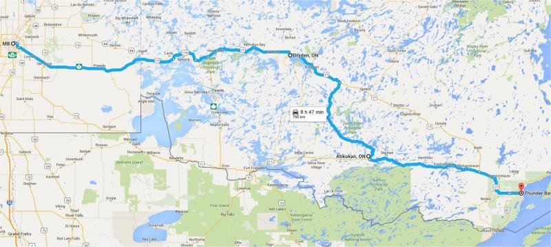
West to east - there are 2 options but this is the one i would prefer. Follow 17 through Kenora and continue approx 70k past Dryden and then turn south down 622 to Atikokan then take 11 to Thunder bay. Lots of lakes, lots of services. You may lose cell service in a few locations but Hwy 622 has some sweepers and vistas that more than worth the extra 75 km

The other option is to take 72 just past Kenora to hook up with 11, but there is a lot of tourist and then mining traffic on that road and it flattens out to farm land past Nestor Falls until Fort Frances.

wpgtotbay.jpg

ooRYS1De6P8w55i6jqBaOY-9HrddLv485S8z_EQTtT7QjwweosFDMSu_8AXLf4ug4Gy2I3lsupDIBqhBudZkHstqCEQRdBZgcBAkgydnVrFJ_9wvpCMV1dSuV-ueYvWjUNYdshypT3GEo4JiQcR0GRHfv4v12AXkVuiqXcvO8_x7O1_e5huujxyTB2vVzTnqj5J_i2gkHbaPB5BM77hdljXRdvdc7Pz2EBNo0J0jstvCiqjOrJL3KxF9xU0JHiRPciK7KtL7Ip1NLgMvIn8Si9Ws7CzlOlDAZ0eDJWI804Bq4mYDDe591pn2PUQ1Rtf4oF2oa2cu8kcMwSCObMExifGjPlORPLm7Zf73EoYGvvP_KBlCt2t_z8F_LHbhBv1oi8_NPTd2byqTtYQyPOABFtiAvymVJxOdJAwN4NvIqqMO8BaR46tbn4CvmZIya_eNbKWXk_sjGqOdweisAkDQEt_1HCXBefFcac7VGWOb6OfQT9HpsAhsuBrYCLfXXFjdRK5u5E63Wc86e6ZLVW6iUoH45zq-CE-9rACJd1ndZb9W=w790-h533-no
 
Last edited:
Thank you garthw!
This was exactly the information I was seeking. I plan to head west from Thunder Bay and take highway 11 then turn north along the Lake of the Woods, stopping at every Tim Hortons I see. Hopefully there will be several on this route.
Thanks again!
 
Thank you garthw!
This was exactly the information I was seeking. I plan to head west from Thunder Bay and take highway 11 then turn north along the Lake of the Woods, stopping at every Tim Hortons I see. Hopefully there will be several on this route.
Thanks again!

As i said the route north along lake of the Woods is pretty flat and once you get near the lake (you only get a glimpse of any lake a couple of times) it will be very busy with tourist traffic. For better scenery (and more Tim Hortons) I really recommend Hwy 11 to Atikokan and then hwy 622 north until you meet Hwy 17 then west through Dryden and Kenora. Highway 622 is a hidden motorcycle riding gem, and you will pass in sight of far more lakes between Vermilion Bay and Kenora. If its a hot day stop and the the Dixie lake rest stop east of Kenora and take a dip.
 
Back
Top