• Welcome, Guest! We hope you enjoy the excellent technical knowledge, event information and discussions that the BMW MOA forum provides. Some forum content will be hidden from you if you remain logged out. If you want to view all content, please click the 'Log in' button above and enter your BMW MOA username and password.

    If you are not an MOA member, why not take the time to join the club, so you can enjoy posting on the forum, the BMW Owners News magazine, and all of the discounts and benefits the BMW MOA offers?

  • Beginning April 1st, and running through April 30th, there is a new 2024 BMW MOA Election discussion area within The Club section of the forum. Within this forum area is also a sticky post that provides the ground rules for participating in the Election forum area. Also, the candidates statements are provided. Please read before joining the conversation, because the rules are very specific to maintain civility.

    The Election forum is here: Election Forum

GPS navigation VS Smart Phone & Apps

ricochetrider

Out There Somewhere
Thought I'd post this here, not knowing if this is the correct or best space... Mods: if not, please move to the appropriate spot, and thanks!

Recently, at the Roadrunner Magazine Touring Weekend, I attended a SAT NAV seminar. The host was of the mind that GPS tech is on the way out, because
A: most of (or much of) the world is now using their smart phones, navigation & mapping apps, etc
B: the [U.S. based] satellites are old (but will be replaced in coming years)

This, of course is 100% arguable, but he was talking about using his phone and mentioned an app, CoPilot USA, within which he converted the provided compressed map files to routes.I was all ready to drop a few hundred dollars on a Garmin GPS, but now am downloading CoPilot USA maps (as we speak, actually). This app costs 9.99 (USD) and stores maps in your device. SO you'll need the space for them. Right now, I'm downloading North America- @ 2.34 gigs. Will also download Eastern USA, Southern USA, and possibly the straight-up USA map as well. These are 477.3 MB, 699.4 MB, & 2.14 GB, respectively.

Having recently gotten a new iPhone 6s, I have all this space, and more.

Not being one to just 100% believe in whatever anyone is selling, I am not ruling out a Garmin in the future, but will try to learn this app and all its ins n outs. Having the ability to convert files to routes etc is a bonus! I've heard repeatedly over the years how clunky and "peculiar" base camp is, so hopefully this will be a little easier to figure out and implement.

It is my own limited experience that tells me Garmin hasn't exactly kept pace with technology as it has leapt forward- case in point: Updates load on top of existing data, so too soon, you are out of space on the device. Garmin seems to be reluctant to really put any effort into making their system and devices more user friendly and modern. Just the same, of course a large percentage of people have used, and continue to use GPS navigation. Apparently, the EU and Russians have new satellite systems in place for navigation abroad, particularly Africa? If the USA is replacing their old satellites, then how is GPS tech a dying means of navigation?

Maybe some day in the future, Somebody will create a reasonably inexpensive GPS and a smarter, more user friendly system within with to operate.

Meanwhile....
anyone using CoPilot? Or other smart, intuitive apps on their smart phone?
 
GPS on the way out...?

Just where do you think the navigation information in smartphones (or any other SATNAV device) comes from...?

It is from satellite navigation (be it GPS [US], GLONASS [Russia], GALILEO [EU], BEIDOU [China]...).

The proliferation of these SATNAV constellations is not due to GPS going away, but to the nationalistic tendencies of countries to not want to TRUST GPS as it is under US control.

Russia and China do not want their military targeting systems dependent upon their adversary - just as the US takes steps with SAASM to secure the GPS system in time of war.
 
Dedicated GPS devices, like my Garmin Zumo 660, serve me better for a variety of reasons.

Greater storage capacity than a "smart phone" usually wishes to sacrifice - the whole USA requires about 4.5 GB of storage!

Louder speakers for delivering info over traffic noise.

Waterproof mounting in front of me on the motorcycle (try that with a "smart phone.")

Ergo, I enjoy my Galaxy S6 as the resource it can be, but have more reliability, weather endurance and better GPS performance with the Garmin.

Use whatever you wish, but my "smart phone" has not yet evolved to where it competes with my Zumo 660. :dance

All eggs in one basket? Rarely advisable. :nono
 
ricochetrider, I understand your thinking and agree that it would be great to have much better nav systems available, but I think we need to recognize that there are significantly different issues at play and perhaps work from there.

I think the presenter was trying to have something provocative to say and, from my perspective failed at it. Sure they'll make very good in-roads into wearables, and occasional or car-based units, but my phone won't help me much on my boat when I'm out of cell range, Definitely won't be used in airplanes in the foreseeable future.

Absolutely more people are turning to smart-phones for navigation and Google Maps is more up-to-date than any GPS can be, but that's comparing apples to oranges and really ignoring many, many important factors. Just look back in history, even recent history and see the tons and tons of predictions that in hindsight were silly. So far this year I've been in 8 states, and 5 provinces and before the end of the year I'll be in another 6 countries and using my GPS in all of them while incurring no additional costs. If I were to try and use a smart-phone to do that, even if it were remotely as good at the task, I'd be racking up very significant data charges that would be crazy. As was mentioned, none of this works without satellites and that's where GPS shines along with on-the-fly usability.

Kevin has added some very good points to consider as well.

  1. A smart-phone isn't very smart if there is no cell-tower signal - think some of the best riding back-roads in North America, much of the Blue Ridge Mountains, etc.
  2. I've not seen many water-resistant smart-phones and don't recall ever seeing one with an IPX7 rating
  3. Phones, especially iPhones, are very fragile compared to any GPS let alone motorcycle specific ones that are built to take the hostile environment of a bike (Most folks I know that use their phones for navigation on their bike have destroyed at least one phone, but I don't know anyone personally, who has destroyed a motorcycle GPS.
  4. The screens on the very best Motorcycle GPSs are only just legible in many high-light conditions found while riding, but far, far better than the very terrible legibility of any smart-phone I've ever had on my bikes. If you can't see it than it's not a fully functioning GPS equivalent.
  5. Speed of recalculation. Never found a phone that could route / re-route / etc., nearly as quickly as a dedicated GPS. After all, there is no satellite receiver built into the phone so, am I correct in assuming that, it must send the request over the cell signal to the satellite signal, get the satellite info back to the cell signal and then deliver it? I don't know, but there is a definite lag-time that can catch you up.
  6. I do a lot of travelling with a GPS and wouldn't even think of giving up the many, many on-the-fly navigation features smart-phones just don't have at all. I've not found anyone that does a lot of travelling in unfamiliar places (don't really need a GPS in areas you know) who would give up the GPS ability to, at the touch of the screen and at their discretion,:
    a) quickly and easily re-route (skip next destination, skip next shaping point, detour, etc.)
    b) display what is ahead (Gas stations, restaurants, lodging, etc.)
    c) provide trip data
    d) provide arrival times and distances to destination and Via points as well as the ability to scroll through them at will
    e) repeat last / upcoming audio directions
  7. Yes, BaseCamp is problematic, but it is a separate app and not the GPS. Current GPS units like the BMW Navigator-V can do 95% of what most people use BaseCamp for
  8. Google Maps can be saved/converted to GPX files and loaded onto most any GPS

Garmin is currently incorporating Google Maps integration into the GPS systems of select VW models and I think other makes as well.

This is what I see as the next big enhancement, the up-to-date data from Google Maps being available on a proper GPS platform with all the functionality that a GPS provides. That will definitely enhance things. Here's hoping BMW Navigator-VI has this ability and is backward compatible with the Nav-V bikes.
 
Going to slide this over to Gear shortly:wave

As mentioned, the GPS works in places a phone will not...enough for me. And my companion maps back it up.
 
I navigated with my Samsung Galaxy S2 for several years, using both CoPilot and Google Maps. Maps is better for "just get me there" trips where cellular service is available for the whole trip. CoPilot worked everywhere, and offered drag-n-drop route editing on the phone. Maps has live traffic re-routing, CoPilot offers that for an extra charge ($10/year??) after the first year. Using the phone as a GPS simplified my Bluetooth connections as I only needed to pair one device to my headset for phone, music and voice directions. Routes planned on my PC using Tyre could be transferred wirelessly to my phone.

The one problem that I could not find a reliable solution for was maintaining power. The USB port just could not cope with motorcycle vibration. I used several adapters, separate battery packs, different cords, different mounts, and a direct-to-battery USB socket. I replaced the micro-USB socket on the phone twice. Every combination I used eventually failed to charge the phone while navigating. In addition, navigating with the display on would drain the battery faster than it could recharge. Turning off the screen and relying on voice commands helped battery life, until the USB port gave up and the phone died. Of course, with no display or voice commands, I might be an hour off-course before I realized the phone was dead.

Newer phones might work better, but I eventually gave up and bought a dedicated motorcycle GPS. The phone is still my choice for GPS in the cage.

Oh, if you download the NA map for CoPilot, it contains all the regional maps. The smaller, regional maps are intended for devices with limited storage.

Alan, you listed some good points regarding fragility and possibly screen brightness, which are critical, but some of your other numbered points are not correct.

With a dedicated app using maps stored on the phone (like CoPilot, Locus or OSMand), there is no need for cellular service, or WiFi, or even a SIM card. The phone does have it's own GPS signal receiver. The newer models like the Galaxy S7 can simultaneously receive signals from three different satellite systems (GPS, GLONASS, BeiDou) to improve accuracy. The Galaxy S5 Active (3-4 years old?), S6 and current S7 models all have IPX7 ratings (The S7 is actually IPX8). Other manufacturers offer water resistance. My four year old S2 will recalculate a four hundred mile route within 50 feet of my wrong turn, I don't know how much more speed is needed. Trip data, logging, POIs, skip waypoint, ETA, etc. have all been available in CoPilot for years. If I could solve the power reliability issues, my motorcycle GPS would be for sale.
 
Last edited:
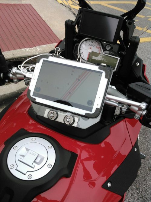
A traveling buds setup on his XR...not rain friendly, but the screen size is impressive.
He's one of those engineers with better mousetrap wishes...or stubborness:whistle

I asked if he ever turns on the NAV :scratch

KIMG1098.jpg
 
ricochetrider, I understand your thinking and agree that it would be great to have much better nav systems available, but I think we need to recognize that there are significantly different issues at play and perhaps work from there.

I think the presenter was trying to have something provocative to say and, from my perspective failed at it. Sure they'll make very good in-roads into wearables, and occasional or car-based units, but my phone won't help me much on my boat when I'm out of cell range, Definitely won't be used in airplanes in the foreseeable future.

Absolutely more people are turning to smart-phones for navigation and Google Maps is more up-to-date than any GPS can be, but that's comparing apples to oranges and really ignoring many, many important factors. Just look back in history, even recent history and see the tons and tons of predictions that in hindsight were silly. So far this year I've been in 8 states, and 5 provinces and before the end of the year I'll be in another 6 countries and using my GPS in all of them while incurring no additional costs. If I were to try and use a smart-phone to do that, even if it were remotely as good at the task, I'd be racking up very significant data charges that would be crazy. As was mentioned, none of this works without satellites and that's where GPS shines along with on-the-fly usability.

Kevin has added some very good points to consider as well.

  1. A smart-phone isn't very smart if there is no cell-tower signal - think some of the best riding back-roads in North America, much of the Blue Ridge Mountains, etc.
  2. I've not seen many water-resistant smart-phones and don't recall ever seeing one with an IPX7 rating
  3. Phones, especially iPhones, are very fragile compared to any GPS let alone motorcycle specific ones that are built to take the hostile environment of a bike (Most folks I know that use their phones for navigation on their bike have destroyed at least one phone, but I don't know anyone personally, who has destroyed a motorcycle GPS.
  4. The screens on the very best Motorcycle GPSs are only just legible in many high-light conditions found while riding, but far, far better than the very terrible legibility of any smart-phone I've ever had on my bikes. If you can't see it than it's not a fully functioning GPS equivalent.
  5. Speed of recalculation. Never found a phone that could route / re-route / etc., nearly as quickly as a dedicated GPS. After all, there is no satellite receiver built into the phone so, am I correct in assuming that, it must send the request over the cell signal to the satellite signal, get the satellite info back to the cell signal and then deliver it? I don't know, but there is a definite lag-time that can catch you up.
  6. I do a lot of travelling with a GPS and wouldn't even think of giving up the many, many on-the-fly navigation features smart-phones just don't have at all. I've not found anyone that does a lot of travelling in unfamiliar places (don't really need a GPS in areas you know) who would give up the GPS ability to, at the touch of the screen and at their discretion,:
    a) quickly and easily re-route (skip next destination, skip next shaping point, detour, etc.)
    b) display what is ahead (Gas stations, restaurants, lodging, etc.)
    c) provide trip data
    d) provide arrival times and distances to destination and Via points as well as the ability to scroll through them at will
    e) repeat last / upcoming audio directions
  7. Yes, BaseCamp is problematic, but it is a separate app and not the GPS. Current GPS units like the BMW Navigator-V can do 95% of what most people use BaseCamp for
  8. Google Maps can be saved/converted to GPX files and loaded onto most any GPS

Garmin is currently incorporating Google Maps integration into the GPS systems of select VW models and I think other makes as well.

This is what I see as the next big enhancement, the up-to-date data from Google Maps being available on a proper GPS platform with all the functionality that a GPS provides. That will definitely enhance things. Here's hoping BMW Navigator-VI has this ability and is backward compatible with the Nav-V bikes.


Agree with most of your points except the one about SmartPhones requiring data for basic navigation - GPS is always running. The SmartPhone only needs data if you are needing live traffic updates, weather etc. I have traveled over much of North America in Airplane Mode using my SmartPhone with TomTom software and maps loaded. Biggest drawback is not being waterproof but cured that with a plastic pouch ($5) made for Phone size I have.
 
This is an interesting thread and I appreciate everyone's comments. Something I'd not thought much about was how smartphone GPS apps actually work. As Ken pointed out, smartphones do have an internal GPS, but apparently some GPS apps still need WiFi or cell phone data access for the maps and real time traffic updates, .etc.

I'm in the process of changing my cell phone from a flip phone back to my previous iPhone, but have not activated the iPhone yet so it has no cell phone connectivity. Last night, I turned off its WiFi and tried two different GPS apps to see if they would work without any external input. Surprisingly, the Waze app seemed to follow my movements based solely on the phone's GPS. However, the old GPS Plus app by Telenav (which is no longer available under that name BTW) would not work.

Lee
 
Good information & discussion here!

Should have prefaced this with this:

I am a complete noob in regards to GPS- I have an inexpensive, entry level Garmin I used to use in my car that barely works. At the Roadrunner Rally, we hooked it up to my friend's Apple laptop and managed to upload converted GPX files into it... but it couldn't seem to open the actual routes -although I could find the files and "access" them in the device. SO I only know what i'm being told (or over hear), and what I read.

That being said, I understand the point of the presenter, which is that the USA defense based satellite system is aging (ha as we all are, right? I'll be 60 in a few day myself) and is slated for replacement. WHEN this will happen isn't exactly 100% certain, near as I could determine. GLONASS and other systems or networks are much newer. Clearly, each country or region builds and implements this for defense, so of course, no sharing. Each system has coverage where whatever entity has interests, or sees a future for their interests (hence- GLONASS coverage on Africa). All GPS "brands" access all the same satellites, but they implement info dissemination differently with variable user interface etc. Since the satellites ARE defense based or intended, OF COURSE they will upgrade or replace them... but we ALL know only too well how good our *beloved* government :wave is at screwing up even the most basic things. :banghead

The presenter was passionate about this whole thing, and I just thought, well hey why not use my phone- I'd just purchased my upgrade 6s which is ridiculously expensive (so, yeah OTOH, why risk ruining it in a thunderstorm?) but seemingly 100% capable of routing me from hither to yon (I use it in my car exclusively nowadays).

Bottom line is that as a noob, I want to explore the possibilities. Roadrunner created their GPX files, not in Base Camp, but in another app, the name of which I cannot remember- I was making notes as we went along but this escaped me as this was said by someone during a discussion segment of the presentation & I didn't quite hear what the guy said.

I'll almost certainly have a Garmin motorcycle specific GPS at some point... but it does peeve me that they cannot seem to (or don't make any effort to) advance their technology into the 21st century, to streamline their updates and app/conversions, etc. To a single person, everybody I EVER spoke to about Garmin and Base Camp has complained about either Base Camp's "quirks" and difficulties, and the updates or support (or lack thereof) from GArmin. I myself have updated the maps in my LM1390 or whatever to the point (3 updates later) of having to buy a micro SD card for the darn thing! Way I understand it, Garmin seems to almost have not advanced their devices, apps, or craft to any degree, or to very minor degrees. AND their newer devices are 600 & 900 dollars! :scratch So not exactly universally accessible. With all the IT expertise available today... wtf. I mean, really. From a distance, the whole thing seems so... 1999. So last century.

Seeing as there are other apps & technologies pretty much exploding all over the place.... why, exactly, wouldn't Garmin scramble to keep up, to update and streamline their processes and devices? WEELLL...
the point the presenter was making (whether true or not, no doubt just HIS opinion) was this is because Garmin knows it's a dying technology and that every body's using their phones! ha ha ha
Which at least a portion of that is completely untrue, as any and all of the more serious motorcyclists I know use a GPS and some app to create and follow maps and routes. and most of the participants at the Touring Weekend were definitely using GPS to access the maps and files that Roadrunner sent out with their routes in them!

So meanwhile, as for powering my "device"... so far I have used my 12v mobile charging devices, plugged into a converter that I bought at the BMW dealership, plugged into a Power Port on my bike. Excess cable going into the tank bag. Honestly haven't used any device long enough for a problem to arise.

As for weather proofing... doesn't Pelican make a small case that's phone-specific & weather capable? Well no matter because heat is an issue for a phone; the thing just has to breathe.

Eggs in one basket? Yeah not so much for me... I use my phone, my clunky old GPS, paper maps, atlases, and hell- I even write directions down on a piece of paper, put them in a zip lock baggie, and tape them to my tank! (if not using a tank bag) I navigate by the sun, moon, stars, wind, geographical features, moss on the north side of the tree trunks, whatever. I've tried to mount a marine compass on my bikes already but could never find one that didn't go haywire when I turned on the motor!

I might need a trailer just to tote all the baskets I want to bring along.

Thanks guys and keep up the good work!
 
Some of us just prefer to remain primitive... I still use my compass and a road atlas...

I was in the northeast states recently, and I had the opportunity to make use of a few different cellphone maps (different phones and different providers) and two in-car GPSs ... the phones were consistently nowhere near as accurate or as understandable as the dedicated GPSs.
 
Good information & discussion here!

Should have prefaced this with this:

I am a complete noob in regards to GPS- I have an inexpensive, entry level Garmin I used to use in my car that barely works. At the Roadrunner Rally, we hooked it up to my friend's Apple laptop and managed to upload converted GPX files into it... but it couldn't seem to open the actual routes -although I could find the files and "access" them in the device. SO I only know what i'm being told (or over hear), and what I read.

That being said, I understand the point of the presenter, which is that the USA defense based satellite system is aging (ha as we all are, right? I'll be 60 in a few day myself) and is slated for replacement. WHEN this will happen isn't exactly 100% certain, near as I could determine. GLONASS and other systems or networks are much newer. Clearly, each country or region builds and implements this for defense, so of course, no sharing. Each system has coverage where whatever entity has interests, or sees a future for their interests (hence- GLONASS coverage on Africa). All GPS "brands" access all the same satellites, but they implement info dissemination differently with variable user interface etc. Since the satellites ARE defense based or intended, OF COURSE they will upgrade or replace them... but we ALL know only too well how good our *beloved* government :wave is at screwing up even the most basic things. :banghead

The presenter was passionate about this whole thing, and I just thought, well hey why not use my phone- I'd just purchased my upgrade 6s which is ridiculously expensive (so, yeah OTOH, why risk ruining it in a thunderstorm?) but seemingly 100% capable of routing me from hither to yon (I use it in my car exclusively nowadays).

Bottom line is that as a noob, I want to explore the possibilities. Roadrunner created their GPX files, not in Base Camp, but in another app, the name of which I cannot remember- I was making notes as we went along but this escaped me as this was said by someone during a discussion segment of the presentation & I didn't quite hear what the guy said.

I'll almost certainly have a Garmin motorcycle specific GPS at some point... but it does peeve me that they cannot seem to (or don't make any effort to) advance their technology into the 21st century, to streamline their updates and app/conversions, etc. To a single person, everybody I EVER spoke to about Garmin and Base Camp has complained about either Base Camp's "quirks" and difficulties, and the updates or support (or lack thereof) from GArmin. I myself have updated the maps in my LM1390 or whatever to the point (3 updates later) of having to buy a micro SD card for the darn thing! Way I understand it, Garmin seems to almost have not advanced their devices, apps, or craft to any degree, or to very minor degrees. AND their newer devices are 600 & 900 dollars! :scratch So not exactly universally accessible. With all the IT expertise available today... wtf. I mean, really. From a distance, the whole thing seems so... 1999. So last century.

Seeing as there are other apps & technologies pretty much exploding all over the place.... why, exactly, wouldn't Garmin scramble to keep up, to update and streamline their processes and devices? WEELLL...
the point the presenter was making (whether true or not, no doubt just HIS opinion) was this is because Garmin knows it's a dying technology and that every body's using their phones! ha ha ha
Which at least a portion of that is completely untrue, as any and all of the more serious motorcyclists I know use a GPS and some app to create and follow maps and routes. and most of the participants at the Touring Weekend were definitely using GPS to access the maps and files that Roadrunner sent out with their routes in them!

So meanwhile, as for powering my "device"... so far I have used my 12v mobile charging devices, plugged into a converter that I bought at the BMW dealership, plugged into a Power Port on my bike. Excess cable going into the tank bag. Honestly haven't used any device long enough for a problem to arise.

As for weather proofing... doesn't Pelican make a small case that's phone-specific & weather capable? Well no matter because heat is an issue for a phone; the thing just has to breathe.

Eggs in one basket? Yeah not so much for me... I use my phone, my clunky old GPS, paper maps, atlases, and hell- I even write directions down on a piece of paper, put them in a zip lock baggie, and tape them to my tank! (if not using a tank bag) I navigate by the sun, moon, stars, wind, geographical features, moss on the north side of the tree trunks, whatever. I've tried to mount a marine compass on my bikes already but could never find one that didn't go haywire when I turned on the motor!

I might need a trailer just to tote all the baskets I want to bring along.

Thanks guys and keep up the good work!

Hey I still carry paper maps and a compass with me. Phones, GPS, or anything electronic will fail/lockup/etc. sometime so don't put 100% faith in them especially if in foreign or unfamiliar territory for you. Enjoy!
 
am I correct in assuming that, it must send the request over the cell signal to the satellite signal, get the satellite info back to the cell signal and then deliver it? I don't know, but there is a definite lag-time that can catch you up.

No.

The GPS signal is broadcast free and in the clear to anyone with an appropriate receiver. The GPS satellites have rubidium and / or cesium atomic clocks on board (with their time slaved to the US Naval Observatory, updated via USAF uplink in Colorado). The satellites are broadcasting information about where they are and what time it is (Universal Coordinated Time). The receiver calculates it's position based on receipt of signals from 4 separate satellites, so that it can calculate for 4 things - latitude, longitude, altitude and time.

There is no communication from the receiver on the ground to the satellites - consider the sheer bandwidth that would be occupied with the millions upon millions of GPS receiver users.

A GPS receiver at a call tower would only determine the position of the cell tower - sending that information to your phone (via communication from the cell tower) is absolutely useless - what good does it do you, since the cell tower has absolutely no idea where you are. Yes, you can triangulate amongst three or more cell towers to locate a cell phone, but that is not going to have the precision to resolve your position that is available with GPS - particularly if you are only in range to a single cell tower.
 
ricochetrider, I understand your thinking and agree that it would be great to have much better nav systems available, but I think we need to recognize that there are significantly different issues at play and perhaps work from there.

I think the presenter was trying to have something provocative to say and, from my perspective failed at it. Sure they'll make very good in-roads into wearables, and occasional or car-based units, but my phone won't help me much on my boat when I'm out of cell range, Definitely won't be used in airplanes in the foreseeable future.

Absolutely more people are turning to smart-phones for navigation and Google Maps is more up-to-date than any GPS can be, but that's comparing apples to oranges and really ignoring many, many important factors. Just look back in history, even recent history and see the tons and tons of predictions that in hindsight were silly. So far this year I've been in 8 states, and 5 provinces and before the end of the year I'll be in another 6 countries and using my GPS in all of them while incurring no additional costs. If I were to try and use a smart-phone to do that, even if it were remotely as good at the task, I'd be racking up very significant data charges that would be crazy. As was mentioned, none of this works without satellites and that's where GPS shines along with on-the-fly usability.

Kevin has added some very good points to consider as well.

  1. A smart-phone isn't very smart if there is no cell-tower signal - think some of the best riding back-roads in North America, much of the Blue Ridge Mountains, etc.
  2. I've not seen many water-resistant smart-phones and don't recall ever seeing one with an IPX7 rating
  3. Phones, especially iPhones, are very fragile compared to any GPS let alone motorcycle specific ones that are built to take the hostile environment of a bike (Most folks I know that use their phones for navigation on their bike have destroyed at least one phone, but I don't know anyone personally, who has destroyed a motorcycle GPS.
  4. The screens on the very best Motorcycle GPSs are only just legible in many high-light conditions found while riding, but far, far better than the very terrible legibility of any smart-phone I've ever had on my bikes. If you can't see it than it's not a fully functioning GPS equivalent.
  5. Speed of recalculation. Never found a phone that could route / re-route / etc., nearly as quickly as a dedicated GPS. After all, there is no satellite receiver built into the phone so, am I correct in assuming that, it must send the request over the cell signal to the satellite signal, get the satellite info back to the cell signal and then deliver it? I don't know, but there is a definite lag-time that can catch you up.
  6. I do a lot of travelling with a GPS and wouldn't even think of giving up the many, many on-the-fly navigation features smart-phones just don't have at all. I've not found anyone that does a lot of travelling in unfamiliar places (don't really need a GPS in areas you know) who would give up the GPS ability to, at the touch of the screen and at their discretion,:
    a) quickly and easily re-route (skip next destination, skip next shaping point, detour, etc.)
    b) display what is ahead (Gas stations, restaurants, lodging, etc.)
    c) provide trip data
    d) provide arrival times and distances to destination and Via points as well as the ability to scroll through them at will
    e) repeat last / upcoming audio directions
  7. Yes, BaseCamp is problematic, but it is a separate app and not the GPS. Current GPS units like the BMW Navigator-V can do 95% of what most people use BaseCamp for
  8. Google Maps can be saved/converted to GPX files and loaded onto most any GPS

Garmin is currently incorporating Google Maps integration into the GPS systems of select VW models and I think other makes as well.

This is what I see as the next big enhancement, the up-to-date data from Google Maps being available on a proper GPS platform with all the functionality that a GPS provides. That will definitely enhance things. Here's hoping BMW Navigator-VI has this ability and is backward compatible with the Nav-V bikes.
Alan, I agree with you on most points. I have comments regarding some of that list.

  1. On board GPS. Most cell phone nowadays have GPS circuitry. You don't need a cell signal for localization. You do need cell coverage or a network to download maps. Offline maps can now be saved from Google maps, maps.me and the app the OP talks about (CoPilotUSA). There are others. You can use a cell with no data plan or even no provider. I have used my Android tablet in Europe to guide me around. It doesn't have cell connectivity.
  2. It is true that most cell phones are not water resistant but more and more are available: http://www.digitaltrends.com/mobile/best-waterproof-phones/
  3. Fragility. With the advent of Gorilla glass and others, cell phone are way better than they used to be.
  4. Legibility. Don't get me started on the legibility of the Nav V.:banghead My cell phone is way better than that. Hell, even my old zumo 550 was better.
  5. Speed of recalculation. High end cell phones are way faster than the best GPS. However, dedicated GPS don't have all those background tasks and apps running.
    Screen redraw (speed) is affected by the number of pixels. Dedicated GPS have very low resolution when compared to cell phones.
    Combine both and the dedicated GPS feels faster than the cell phone but they're not.
  6. Features and points of interests (POI).
    a)agree there. Google Maps limits the number of waypoints and there is no easy way of erasing, skipping, one on the fly. Some apps just don't allow you to add waypoints.
    b)That is the main strength of dedicated GPS' IMO. It would be a lot better if Garmin would provide an easy way to update them. How many times have I looked for a gaz station, restaurant or hotel on my GPS and found that it wasn't there or gone out of business? I believe Tomtom is better at that. Cell phone based apps with offline maps have those too but are limited if used without a network or cell connection. Business info is more up to date in Google Maps.
    c)No question there.
    d)No question there.
    e)No question there.
  7. Agree the conviviality or user friendlyness of Basecamp is appalling. Garmin should hire the developers of Street and trips.
  8. Google Maps to GPX to GPS. Yes but you lose all the extra info. It gives you only the basic route. Third party apps or websites are required to create routes the way riders want them.
Other features dedicated GPS have: lane directions both visual and voice prompts. Much appreciated when getting to major highway intersections or little back road forks.
There is also the legal issue: some jurisdictions have banned the use of cell phone while driving. Hands free (talk) may be allowed but don't touch that cell phone. DAHIK The phone may be in a cradle but don't touch it while driving. Driving aids, like a GPS, are usually allowed.

Agree with most of this excepting TomTom has an App for Smartphones that does give lane directions, turn by turn etc. visually and audibly (direct from the speaker or via Bluetooth which the Phone can be paired to by many communicator manufacturers therefore is hands-free). Route planning available from a laptop via TYRE software (I have not use this and cannot speak to whether it is as good, better or worse than Basecamp).
 
I am using a 10 year old Garmin handheld and for 3 years I carry a tablet with CoPilot with me. I have the newest maps on my Garmin and I update the CoPilot maps regularly. I had a couple of situations where I could not find an object (like a gas station in a remote area) on my Garmin while it was on CoPilot and vice versa.

My Garmin is rock solid! It is IP7 and floats (I use it while sailing). And how much can you improve a 'hammer'? Some...

CoPilot has a feature which I would like on my Garmin: I can search for objects ALONG my defined route.

My Garmin has real buttons with which by now I can make entries without taking my eyes off the road. I still fail to do that on a touch screen.

And keep in mind: GPS is just a way to tell you where you are. It's the maps and database of objects which makes it a navigation and information system. While all these devices/phones have GPS they differ in the way you can use them. And some have remarkable bad user interfaces and there seems to be none that is A+.

So, I carry on my trusted 10 year old Garmin with update maps.

/Guenther

Newer Garmins can do searches along a route. EG, Nav V
 
.... The one problem that I could not find a reliable solution for was maintaining power. The USB port just could not cope with motorcycle vibration. I used several adapters, separate battery packs, different cords, different mounts, and a direct-to-battery USB socket. I replaced the micro-USB socket on the phone twice. Every combination I used eventually failed to charge the phone while navigating. In addition, navigating with the display on would drain the battery faster than it could recharge. Turning off the screen and relying on voice commands helped battery life, until the USB port gave up and the phone died. Of course, with no display or voice commands, I might be an hour off-course before I realized the phone was dead.

Newer phones might work better, but I eventually gave up and bought a dedicated motorcycle GPS. The phone is still my choice for GPS in the cage...
...as for powering my "device"... so far I have used my 12v mobile charging devices, plugged into a converter that I bought at the BMW dealership, plugged into a Power Port on my bike. Excess cable going into the tank bag. Honestly haven't used any device long enough for a problem to arise...
That has worked for me as well. I've not had any issues with DIN or SAE connectors coming loose, but USB and "cigarette-lighter" ports do/can work themselves loose.

...You can use a cell with no data plan or even no provider. I have used my Android tablet in Europe to guide me around. It doesn't have cell connectivity...
....With a dedicated app using maps stored on the phone (like CoPilot, Locus or OSMand), there is no need for cellular service, or WiFi, or even a SIM card. The phone does have it's own GPS signal receiver. The newer models like the Galaxy S7 can simultaneously receive signals from three different satellite systems (GPS, GLONASS, BeiDou) to improve accuracy...
...The SmartPhone only needs data if you are needing live traffic updates, weather etc. I have traveled over much of North America in Airplane Mode using my SmartPhone with TomTom software and maps loaded. Biggest drawback is not being waterproof but cured that with a plastic pouch ($5) made for Phone size I have.
Good to know, thanks for correcting my mistake, I'll try it out right away.

... apparently some GPS apps still need WiFi or cell phone data access for the maps and real time traffic updates, .etc...
That had been my experience when I tried it out a couple of years ago Lee, but from the observations above, it would appear that things have changed and I have some experimenting to do.

....The Galaxy S5 Active (3-4 years old?), S6 and current S7 models all have IPX7 ratings (The S7 is actually IPX8). Other manufacturers offer water resistance...
...It is true that most cell phones are not water resistant but more and more are available: http://www.digitaltrends.com/mobile/best-waterproof-phones/..
Good to know that they are finally rwalizing that some people lead active lives and go outdoors sometimes.


...As for weather proofing... doesn't Pelican make a small case that's phone-specific & weather capable? Well no matter because heat is an issue for a phone; the thing just has to breathe...
I have one but haven't used it precisely due to the high heat generated by the phone. The last thing these new phones need is to be in an enclosed space while charging. I've had friends who used their phones for a GPS and mounted them in the map window of their tank-bags only to have real temperature issues. For most phones, I think, we are still dealing with a product that is not ideally suited to the intended environment and task, but perhaps they are getting very close if they can get temperatures down to reasonable levels.


....My four year old S2 will recalculate a four hundred mile route within 50 feet of my wrong turn, I don't know how much more speed is needed. Trip data, logging, POIs, skip waypoint, ETA, etc. have all been available in CoPilot for years...
Downloaded CoPilot last evening and will start exploring it. I've got a trip to Florida next month and in November will be in six different countries in Europe so I'll be able to see how well it works vs my Garmin.

As for speed being needed, typically that 50 feet would be more than enough, but I've found a lot of areas in Europe, especially in places in the mountains where one is travelling at high speeds, enters a tunnel that is so long that the GPS looses it's way and upon exiting the tunnel I've been presented with a direction change. My Garmin 390LM just recalculated in time about 1-2 out of every three times. The rental car's OE GPS caught perhaps 1 out of three, and my cell phone (I had a big data package because I thought it required data for it's GPS) might have caught 1 in 5 which on a toll-road freeway gets very expensive ($30-$50/day in tolls isn't unheard of there).

...the point of the presenter, which is that the USA defense based satellite system is aging...
The presenter was passionate about this whole thing...
I can't figure out how that would have any bearing on which source (GPS vs phone) you should use to get your GPS directions from? I don't see any connection if every device one is going to use has the same original source than how does it matter? Perhaps I'm missing something.

As far as there being differences in satellites between North America, Europe and Eastern Europe, I've used my TomTom and Garmin GPSs for many thousand miles in each of those three areas and never had any issues with my Garmin's accuracy nor noticed any differences between the three areas except in Serbia, where, I've been told by someone who works in that field in Serbia that the problem is with the Serbian government not releasing controlling access to that data to a far greater degree than most other places.

...Roadrunner created their GPX files, not in Base Camp, but in another app, the name of which I cannot remember...
Might have been Rever.

...why, exactly, wouldn't Garmin scramble to keep up, to update and streamline their processes and devices? WEELLL...the point the presenter was making (whether true or not, no doubt just HIS opinion) was this is because Garmin knows it's a dying technology and that every body's using their phones! ha ha ha
Which at least a portion of that is completely untrue, as any and all of the more serious motorcyclists I know use a GPS and some app to create and follow maps and routes. and most of the participants at the Touring Weekend were definitely using GPS to access the maps and files that Roadrunner sent out with their routes in them!...
I agree that this is likely qute inaccurate.

Aside from the motorcycle and car/truck market, which will certainly see erosion from cell phone incrusion, there is a large and profitable market in expensive dedicated GPS units for boats and airplanes that won't be going away anytime soon, and they are far closer to being necessities not personal choice options as a motorcycle GPS is. I've got two large marine GPS units and they are far more difficult to use than an automotive/motorcycle GPS and far more expensive, with no life-time maps, etc. Garmin, Standard Horizions, North Star, Lorance, Raymarine, Hummingbird, Magellan, Fusion, etc., all have a lot of offerings in this market, starting at a bit over $200 and going well over $4,000. I think the presenter was looking at what is happening in narrower market and extrapolating that across the entire market without perhaps being well aware of it.

Some of us just prefer to remain primitive... I still use my compass and a road atlas...

I was in the northeast states recently, and I had the opportunity to make use of a few different cellphone maps (different phones and different providers) and two in-car GPSs ... the phones were consistently nowhere near as accurate or as understandable as the dedicated GPSs.
Most of my riding is also in the Northeast US and Eastern Canada and my experience has been the same, perhaps it is a regional thing but I'm not sure why if cell phones are only using satellite info?

...Fragility. With the advent of Gorilla glass and others, cell phone are way better than they used to be...
Yes they are, but it seems to me that they are still failing at a much higher rate than GPSs are, certainly that's been my experience, albeit from a very small sampling (people I know). ;-)

...Legibility. Don't get me started on the legibility of the Nav V.:banghead My cell phone is way better than that. Hell, even my old zumo 550 was better...
Definitely agree that the Nav-V needs to have it's visibility improved, like you, my 390LM was better, but I still haven't found a phone that works any better or even as good in the sun with my sunglasses on. Heck, I have a hard time reading a cell phone hand-held in the sun with sunglasses on, typically take them off to see the screen at all. I think the problem is that my sunglasses are designed for marine environments and therefore are polarized like most screens which blackens the phone screen (double polarization), but I don't want to invest in a pair of aviator glasses for this. :-(

...Speed of recalculation. High end cell phones are way faster than the best GPS. However, dedicated GPS don't have all those background tasks and apps running.
Screen redraw (speed) is affected by the number of pixels. Dedicated GPS have very low resolution when compared to cell phones.
Combine both and the dedicated GPS feels faster than the cell phone but they're not...
Perhaps I need to upgrade to a high-end cell phone, as I've not had that kind of speed from my phones once they're loaded with my 100+ apps. However, then we're talking prices that are around the range of a BMW Nav-V and as was mentioned, putting all your eggs in one basket, so I'm not sure about that part of it. I like the idea of trying my old cell phone that has no service provider and therefore isn't racking up an expense and is less critical to me.
 
It is amazing how eloquent and detailed you guys are about cellphone gps and how amazingly wrong. There are any number of gps apps that are equal to dedicated gps. For instance, copilot, sygic, wake, NAVIGON and maps.me and there are probably others. I have all of these and they work on my iPhone SE with or without cellular access. As to battery drain, if you will use a 2 amp charger the lphone works fine. Also I started using phone gps with the iPhone 3 and with the exception of some power problems early on I have never had an iPhone fail. And this included a lot of miles on gold wings, st 1100, RT'S and R1200GS for the last 6 years and 60,000 miles. This has been my experience and I'm sticking to it. So flame away !


Joe

No flame throwers pointed in your direction, Joe. To each their own.

You like cell phone navigation - great.

But your positive experiences do not address weather protection, larger screen and several other differences that we 'dedicated GPS users' appreciate.

Corinth, MS....eh. Stayed there one night during a 14 state ride. The lobby of the motel my son and I slept at has two replica soldiers of the Civil War in full uniform, honoring the fact that "each fought for what they thought was just and right."

A photo even appeared in Part 1 of a 3-part touring story that Owners's News publisher Mandy featured three-months consecutively in the ON, back in the day when I was still published. :thumb
 
Back
Top