• Welcome, Guest! We hope you enjoy the excellent technical knowledge, event information and discussions that the BMW MOA forum provides. Some forum content will be hidden from you if you remain logged out. If you want to view all content, please click the 'Log in' button above and enter your BMW MOA username and password.

    If you are not an MOA member, why not take the time to join the club, so you can enjoy posting on the forum, the BMW Owners News magazine, and all of the discounts and benefits the BMW MOA offers?

  • Beginning April 1st, and running through April 30th, there is a new 2024 BMW MOA Election discussion area within The Club section of the forum. Within this forum area is also a sticky post that provides the ground rules for participating in the Election forum area. Also, the candidates statements are provided. Please read before joining the conversation, because the rules are very specific to maintain civility.

    The Election forum is here: Election Forum

St. Louis to LA - in late May - route ideas?

deilenberger

A bozo on the bus
I've got my route pretty much figured out from Morton's Spring Fling to St Louis. Some actual decent interstate (I-64, especially in WV) and then Rt 50 from Lexington to St Louis, but my mind is drawing a blank from there to LA.

My riding style is - smaller highways, avoid a lot of truck traffic, +10 on the speed limit (except in small towns - then it's exactly the speed limit - or unless the limit is 80+ when I think that's reasonable, especially in places like Texas.) Like to visit old towns - active and semi-deserted. Have gone coast to coast to coast about 5 times now by car, it's time to do it by bike, and I've been given a month to do it. I do like to take a break every 3 days or so and spend 2 nights in one place to unwind from riding for a bit. I'd prefer to avoid as much of Texas as I can, love Arizona and New Mexico. Figure I have about 10-11 days to go from St Louis to LA..

The first time I went across country was 1968 - and we took a good part of Rt 66. I remember being in the Ozarks just west of St Louis and loving the roads and scenery.

I'm good for 6 to 8 hours a day on the bike, but prefer to break the day up a bit with sprints of 2-3 hours, then a break for an hour, then on again.. I do try to avoid night riding 'cause there are just too many critters.

What are your ideas?

BTW - last year I posted here asking about Europe, and got some excellent info. Had a stellar trip, even though we didn't quite get to Barcelona (my riding companion lost his passport in France, and it took a bit too long to get a new one, so we skipped Barcelona.) For some videos of that trip: https://www.youtube.com/playlist?list=PLTqrNTXGQW1Z9Gu5Y3zX1Ftg-kFdk6aJE
 
I'd take 50 to Jefferson City, MO and then US54 all the way to Tucamcari, NM. Interstate to Santa Rosa and then drop down to Carrizozo. Then do a weave and bob over to the Phoenix area - and from there can hit I-10 when you get tired of the backroads. Once into the desert west of Phoenix the interstate is a good option.
 
I live south of Exit 50 on I64 in S. IL. 50 miles from the Mississippi River. If you need a room for the night, let me know.

Bud
 
Southern Rockies route?

If the weather is too warm for a southern AZ route, consider:

St. Louis, Jeff City, Nevada, MO.....Wichita and Dodge City, KS.....Pueblo, Gunnison, Montrose, Durango, CO....Page, AZ....St. George, UT, Las Vegas, LA.

Gives you some good riding in the southern Rocky Mountains (including the Million $ Hwy), and lots of scenery in northern AZ/southern UT.
 
Hi Jim,

Indeed when I plotted out the "southern" route and then started looking at it - I found lots of the route was currently (in April) well over 100F during the day. Palm Springs was 105F. Although the nights cool off - animals (of all sorts) then come out, making riding a bit more hazardous.

Here are some of the routes I've considered:

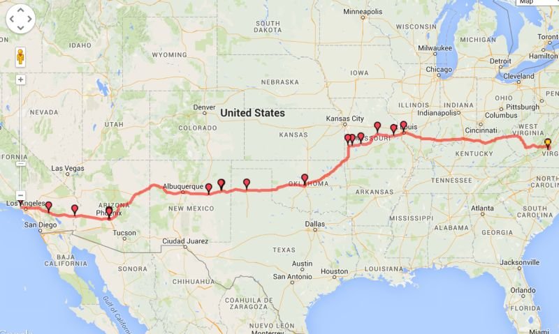
Southern Route - 2635 miles - small.jpg

#1 - This is the southern route. It's 2635 miles long, and doesn't seem too bad until it heads south toward Phoenix. Then it just gets unbearably hot.

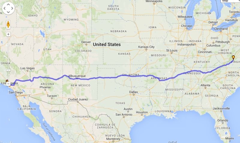
Shortest Route - 2489 miles - Small.jpg

#2 - This is the "fastest" route. Two data-points, one in VA one in CA - letting Tyre/Google route it the fastest/shortest route. It's 2490 miles. Not a huge difference in the grand scheme of things.

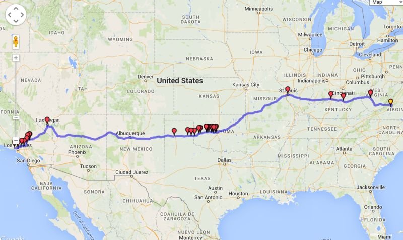
Mostly Rt 66 Route - small.jpg

#3 - This one is "Mostly Rt 66" once I leave St. Louis. Obviously Rt 66 isn't around in lots of areas, but it's surprising how much of it - where it went through towns - still exists. The number of waypoints in Oklahoma are a clue to that - there is quite a bit of Rt 66 in Oklahoma still paralleling the superslab, and they've made quite the tourist attraction of it. This is 2625 miles long (including off-shoots to get to Rt 66 and wander around a bit.)

To be continued..
 
Continued from post above..

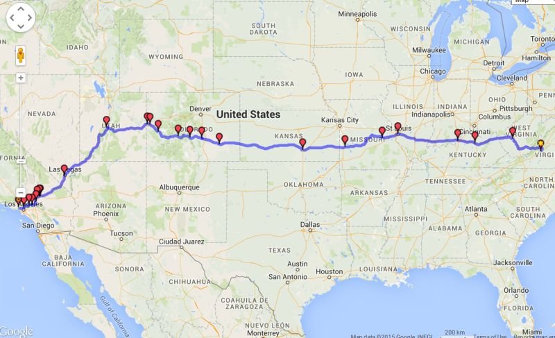
Rt 50 and Rt 66 - small.jpg

#4 - "Mostly Rt 50" (once I leave St Louis) - follows one of the other "National" roads - and I think it likely close to the route you suggested. I think the heat should be much better (although between Las Vegas and LA is going to be "interesting"..) I figured might leave Las Vegas around 5:30AM as it starts getting light, and try to get to the Barstow area ( ~2 1/2 hours, 150 miles) before the real heat of the day. If it's hot - stay overnight in Barstow, then repeat the early AM riding the next day to LA - giving myself the treat of Angels Crest Highway to drop into LA (~4 hours, 165 miles or so.) Total for this route - 2,750 miles.

Suggestions, comments - more than welcome.

BTW - the program I'm playing with the routes with is called "Tyre" - nice overlay program for Google maps. Gives you all the features of Google Maps, adds in it's own routing algorithm, plus POI's, plus it will upload directly to the Garmin/BMW GPSs (and many others). Only problem is - it uses the Google maps which are a different mapset then Garmin uses, so sometimes the routes do very odd things with loops and such. I found it most useable to find/create what they call "Waypoints" - and export them as Garmin custom POI's.. then stitch the custom POI's together into a route using the Garmin internal routing. It seems like it might be trouble to do - but it's much better then my fumbling around with BaseCamp (a more non-intuitive program would be hard to imagine.) Tyre is free (or very low cost subscriptions which add a few features and removes ads which aren't actually annoying anyway..) Google for it..
 
I live south of Exit 50 on I64 in S. IL. 50 miles from the Mississippi River. If you need a room for the night, let me know.

Bud

Bud - thanks. Just looked - you must be near Nashville IL? Possible. Will know more as the time gets closer. Can you PM me with contact info?

Thanks!
 
Don:

Isn't this a great problem to have???!!! Yippee!! I think it's safe to say that you'll have a great time, regardless of the route you choose!

I rode from Springfield VA to Amarillo on the route you show as "fastest route". It was September 2012 and the scenery through VA, TN and AR was great, even for riding the slab. I hit OKC at 2 in the afternoon and it was 102. I quit for the day, and as you mention for the route between Las Vegas and Barstow, hit the road the next day at 4 am to avoid some of the heat!!

Tyre looks interesting, I'll give it a go!! I've used the Harley Davidson Ride Planner before, and thought it was good too!

Good luck!
 
Back
Top