• Welcome, Guest! We hope you enjoy the excellent technical knowledge, event information and discussions that the BMW MOA forum provides. Some forum content will be hidden from you if you remain logged out. If you want to view all content, please click the 'Log in' button above and enter your BMW MOA username and password.

    If you are not an MOA member, why not take the time to join the club, so you can enjoy posting on the forum, the BMW Owners News magazine, and all of the discounts and benefits the BMW MOA offers?

  • Beginning April 1st, and running through April 30th, there is a new 2024 BMW MOA Election discussion area within The Club section of the forum. Within this forum area is also a sticky post that provides the ground rules for participating in the Election forum area. Also, the candidates statements are provided. Please read before joining the conversation, because the rules are very specific to maintain civility.

    The Election forum is here: Election Forum

MOA-StPaul Rally: Neighborhood FYI

Reason I asked is that on page 129, July MOA mag shows gate three Hoyt and Snelling as "in"only. Gate one, Larpenteur Ave., shows "in and out".

Thanks for pointing that out. I'll need to edit several of my Picasa album info-graphics 'arrows' (and posts) so the entry/exit matches July ON p129. [I've been mostly focused on other fyi stuff, overlooked that] With Hoyt as 1-way only, it's more arrival-friendly as a 2nd 'IN' point. Also tiny print on p.129 map says "Vendor Entrance/Attendee Exit" at DanPatch onto Snelling; that's also good.

Duane S
 
Last edited:
Reason I asked is that on page 129, July MOA mag shows gate three Hoyt and Snelling as "in"only. Gate one, Larpenteur Ave., shows "in and out".

Larpanteur is 2 way - entry/exit. Hoyt is entry only, and Snelling is exit only.....
 
added info-graphics:
# Hennepin Ave: a handy route to explore Mpls/Uptown/lakes w/o expressways
# MIA: Minneapolis Institute of Arts ..a must see! easy access (more later)
# MN public radio: 5! unique stations ..start streaming! Plus: MN Original video

How is Como for getting to the Rally going from around the Capital building to the Rally?

Bill in Phoenix
 
How is Como for getting to the Rally going from around the Capital building to the Rally? Bill in Phoenix

Como is relatively empty of traffic :) ..or storefront activity. Rally riders may be nicely surprised how little traffic there is on any street in this entire zone of neighborhoods between Mpls/StP downtowns.

BTW, on GoogleMaps, zoom far-in at near-west of State Capitol between Como (NW), Western (N-S), University (E-W):

# Hmongtown Marketplace is at Como&Marion in a converted lumber-yard. That's because StPaul has the 2nd largest USA population of Hmong outside homeland Laos (30000, 66k in MN; WI 49k, CA 91k). [In Vietnam, the CIA-sponsored Hmong secret army fought against Vietcong along Ho Chi Minh Trail] ~ FWIW, Mpls/StP/MN also has the largest USA population of Somalis (33000) outside Somalia~ Nevertheless, the rally-area experience will largely be Caucasian ;-)

# "Little Mekong District" is how the City of StPaul is starting to promote the area along University Ave E&W of of Western Ave. Zoom in far enough to see a number of Thai and Vietnamese restaurants. Bangkok Thai Deli seems always busy, (tried it, fresh! on-site parking). Also: StPaul/Little Mekong has picked five Saturday summer evenings (5-10pm) to host a small "Little Mekong Night Market" to give MN-folks a SE Asia experience with live music. The 5July night market had funky African drumming: this area is/was also the 'Rondo' black neighborhood since 1900, but it has never recovered from the 1960s urban development fiasco: dig a trench, put I-94 in it. Night Market is next-to/behind Mai Village restaurant at Univ&Western; next date is Sat 26 July :)

University Ave has struggled to prosper. A backbone of urban activity since 1880s (department stores, ballrooms, night clubs), it got hollowed out in post-WWII as folks moved/drove to the suburbs, streetcar lines ripped up etc). The new immigrant populations may re-boot University Ave ..together with the field-of-dreams brand new Green Line LRT (to attract boomers/hipsters to a potentially 'walkable' urban life)?

# at Dale (next major N-S street to west) and Minnehaha (at big Dragon Star Market) is where one can hop on Pierce Butler truck route (traffic-free no-lights) which has a left exit onto (and runs under) Snelling (for rally entrance). I've noted it in several of my album info-graphics. However, traffic isn't really a problem around here.

Duane S [StP]
 
Last edited:
walkable healthy options?

[To avoid cross-posting, and to consolidate my 'rally neighborhood' comments, I've moved my response about "walkable healthy options/grocery?" in the "St. Paul Food Vendors" rally thread to here.]

Well you would be able to walk to healthy options if the fairgrounds west-side street gates were open (but they're not; rally can't really have them all open). A sorta straight-line 1km walk west from rally-center on Randall to Buford thru U.MN-StPaul 'Ag' campus ('dead' in summer) across Cleveland [N-S] would bring you to Lori's Cafe (coffee, flavored drinks) and the adjoining Mim's Cafe (middle-eastern) ..and then 5 blocks more into [my] StPaul very walkable StAnthonyPark (SAP) neighborhood ..a village-within-a-city, with it's unique 1.5-block foodie-friendly 'main street' (Como Ave) containing Speedy Market, Colossal Cafe, Finnish Bistro/Dunn Bros and Muffelleta ..all with sidewalk tables. [+post office, independent bookstore, wine shop, Carnegie library, gas] Most SAP residents cherish their environmentally/politically/nutritionally-correct sensibilities, so the menus reflect that. A mini-tour: Homes in SAP (north of the rail-yards) are architecturally diverse (design/size), many from 1880s-1920s, so do a meandering ride/walkabout 3 blocks either side of the Como Ave 'backbone'.

To reach SAP streets during the rally, ride around the fairgrounds perimeter on Como or Larpentuer+Cleveland [N]). Once riding, it's simple to continue down Raymond over the rail-yards (2 micro-breweries down there, limited hours) to Hampden Co-op (organic+/-), then to the last block of Raymond at University (it's still SAP): Foxy Falafel (x-food truck) and the original Keys restaurant (which has the old dark-wood booths character the equally-tasty suburban Keys locations lack; off-street parking in back). Next door: tiny Noll Hardware (crammed full), and the new&tiny Barely Brothers Records (all-vinyl, live bands). ~ SAP folks don't often experience motos, so courteous, quiet BMWs would be useful public-service PR on behalf of all riders ;-)

Duane S

[The rally enter/exit gates are all oriented N/NW/NE/E toward suburban Falcon Heights and Roseville, whose several malls and strip-malls have a variety of food options (some family-owned, several corporate franchises). I'm highlighting the near-west 'SAP' neighborhood Como/Raymond shops because, rally gates-wise, riders might not discover it.]
 
Last edited:
open spaces, stadiums, weather

An idle thought: it's sorta cool that a MOA International BMW Rally is located in a hassle-free plenty-of-tent-green-space site (MN state fairgrounds), next to lovely open green-spaces (UMn golf course, UMn ag research fields, Como Park) ...and yet is only a 10-15min ride (Hennepin Ave westward, light traffic), or a 3.5-5.5mile hike, to the stadiums hosting:

* MLB All-Star Game (MN Twins Target Field) 15July2014
* NFL MN Vikings (new stadium: Super Bowl 2018)
* EPL Manchester United vs Olympiacos (UMn TCF Bank Field) 2Aug2014 International Champions Cup tour
* NBA MN Timberwolves (Target Center: last LRT stop)
* WNBA MN Lynx 2013 WNBA Champions (Target Center) Fri 25July vs San Antonio
* NHL: MN Wild (Excel Energy Center): Como Ave east to downtown StP
* StPaul Saints baseball (Midway Stadium, 1 mi south) Th 24July vs Sioux Falls
:)
What other potential USA rally site has that? Plus the long-distance arrival/departure routes opportunity to ride thru the curvy county roads of hilly non-glaciated topography (NE IA, SE MN, SW WI) and along Mississippi Great River Road ..or around Great Lakes thru the woods-wilderness of northern WI/MN, or thru Badlands of Dakotas, Black Hills, etc?

About MN weather: it *changes* 'whenever' ..could be perfect 78F and dry, or a 1/2" rain becomes 2" downpour, then clear in 2hrs (systems keep moving, not socked-in), or 95F high one day then 55F high the next (it has happened). However, BMW riders are ever-prepared.

Duane S [go! Green Bay Packers]
 
Last edited:
album additon..

Added latest info-graphic: a wider overview covering i94/University south of fairgrounds northward thru Roseville (the land-of-malls, strip-malls), indicating hardware stores (w/metric parts bins), supermarkets, food co-op, family-owned diners, REI, B&N, USPS, Target, Walmart, Kohls, etc. [Note: this JPG is 1300 pixels LxW, so to read details one needs to scroll at 100% 1:1]

BTW, my various info-graphics are not intended to draw folks away from the rally on-site food vendors or events ..it's just where-stuff-is FYI for riders.

I've added info-graphics to my Google PicasaWebAlbum..

MOA2014StPaul^rally neighborhood FYI [view FullScreen 100%]
 
Last edited:
Best route from Great River Road

We will be coming up 35 along the WI side of the river and plan to get to the rally mid day on Thursday. Does it make sense to come up 10 to 494 and go west to 35E, north to Ayd Mill, and north on Snelling to the site?

Man, I do a lot better on the WNC twisties than urban areas. LOL
 
We will be coming up 35 along the WI side of the river and plan to get to the rally mid day on Thursday. Does it make sense to come up 10 to 494 and go west to 35E, north to Ayd Mill, and north on Snelling to the site?

Man, I do a lot better on the WNC twisties than urban areas. LOL

If it is rush hour then it maybe a good option. Worst rush hour here is going to be 4-6 p.m.

Remember I live here, have my whole life, I drive 10/61 to I94 a few times a month. Going through downtown St. Paul is sort of hairy and I imagine it will seem much more so if you are not familiar with the area and even more so if you are from a rural area. For riders that are used to freeway metro traffic I94 to Snelling is an ok option especially if it is not during rush hour.

Another option is to get on to the Road Road from 10/61 it is the last stop light - left turn before I94. I just checked, it is called Warner Road at the turn. follow it along the river and it will change names to Shepard Road. Turn right on Otto Ave, then Left on West 7th. Go north onto 35E (that is going to be a left hand turn) the second exit is Ayd Mill Road.

Steve Handeland
Hospitality Co-Chair

Yes, now I see Warner and Shepherd. I was not zoomed in enough before. Your route make sense, thanks.


Jeff Masterman
 
Minneapolis Institute of Arts: why&how

I'm promoting the MIA (Minneapolis Institute of Arts: new.artsmia.org) simply because having such easy access to one of the country's significant museums is a rarity for any MOA rally. Probably not on the radar of most riders; nor such opportunity near home?

Of course every state's major metro city has its core museum ..but how often do you get there? ..at what hassle, entrance/parking fee? How about FREE? (donations welcome).

MIA is satisfying because, unlike NYC/SF/etc with separate museums for various arts, the arts from world cultures are in one MIA building. OTOH, it's not the Met/MoMA, Louvre, Rijks, British, V&A, National Gallery (DC or London).

~Hassle-free route (6.8mi, 16min): simply ride west on Larpenteur/Hennepin, take i35W south, stay in right lanes because you're getting off soon (and before any i35W/i94 issues!) at second exit (11th Ave), then left/south only 3 blocks (over i94 you're not in), to right on Franklin for 9 blocks (over i35W traffic that you're not in) to left on 3rd Ave South 2 blocks to MIA. [see route graphic in PicasaWebAlbum]
~Parking: Ride up to 3rd Ave main entrance in case there are moto-gaps among parked cars, or on next street east of that large green space. Lock gear on bike, or use coat-check inside entrance.

I'm just an old farm kid who was taught not to pass up an opportunity to learn something new, and lacking arts-skills and aware it's not cool to be willfully ignorant, it seems wise to visit the MIA ..if only to have a clue for the sake of one's kids/grand-kids, nieces/nephews etc. Once inside, the same appreciation one has for the design and technique of BMW moto-details will likely transfer to the centuries of materials displayed in the various galleries ;)

BTW, visiting MIA need not conflict with MOA rally events or countryside day rides: open 10-5 STWFS, one could 'do' it after Wed tent set-up, or after Sunday pack-up and breakfast while heading home. Also open 10-9 Thur, one could visit between last rally seminars and evening entertainment. A basic walk-through of galleries (2 levels) takes 1-2hrs. [see galleries diagram in PicasaWebAlbum]

Duane S [Copa Mundial: GER 1-0 ARG, tiempos extra]

some additional content for the GooglePicasaWebAlbum:
MOA2014StPaul^rally neighborhood FYI [view FullScreen 100%]
 
Last edited:
We will be coming up 35 along the WI side of the river and plan to get to the rally mid day on Thursday. Does it make sense to come up 10 to 494 and go west to 35E, north to Ayd Mill, and north on Snelling to the site?

Steve's option (post#30) to Ayd Mill works. I'll add that one need not 'always' avoid i94. Hwy 10/61 (just past that Warner Rd light) merges well enough into i94 a couple miles east of downtown StP. The potential OMG! mess is that badly-designed downtown StP i94 double-S curve as drivers maneuver to get (right lane) onto i35E north, or left for i35E south, the same lanes other folks use to merge onto i94! The trick is to stay in i94 west's 2nd-from-left lane, or at least keep out of the right lane, and you'll pop-out the other side of downtown StP on an ordinary i94 straight west toward Snelling, wondering what-was-that?

In my online info-graphic album, I've suggested using the Ayd Mill shortcut off i35E, noting that it ends abruptly (onto Selby) a block short of Snelling; also: keep going straight (right lane) on the last bit of Ayd Mill; most cars may turn-off leftward (their neighborhood) but it keeps going even though it may seem otherwise. In any case, it puts you onto Snelling just south of i94, so if there is i94 on/off congestion in the half-mile stretch of Snelling either side of i94, plus similar issues near-by at University Ave ..then taking i94 in the first place also works (because you skip any backup at Snelling lights south of i94). Once you're north of University, Snelling flows well enough 2 miles to the rally fairgrounds. Or, if on i94 and you want to mentally decompress on some more neighborly street, exit i94 earlier on Lexington up into Como Park ..then briefly wing-it NW-ward a few blocks on residential streets (Hamline, Hoyt) to either rally entrance.

BTW, taking WI35, then 10 across the junction of St.Croix and Mississippi rivers to 61 works because, even though there are stoplights along 10/61 to i94, traffic often moves fast (70mph?); seems odd, LEO-wise. Both WI35 and US61 along Mississippi (from LaCrosse WI area) are scenic and fast, but on the MN side 4-lane hwy61 loses the river at Frontenac beyond Lake City, whereas 2-lane WI35 keeps you thru small burgs with tasty diners [Alma, Nelson].

BTW#2: MSP metro area has lots of lateral commerce traffic between outlying areas; so seemingly-bypass roads like i494/i694 may often be more congested than i94. Once i94 has unloaded all the folks heading toward (commuter roads between) outlying greener pastures/lawns, it's mostly OK. <> The reason that i94-to-University short stretch of Snelling gets jammed up is 'other folks' (or their GPS app) thinks they need to pass thru there to wherever, even though University&Snelling isn't a destination.

Duane S [rally neighbor]
 
Last edited:
MSP traffic .. all's green

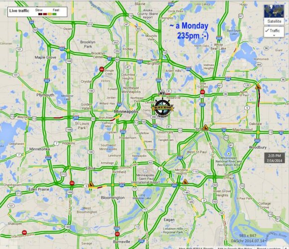
As a counterpoint to fretting about MSP traffic congestion, I've attached a Monday 235pm GoogleMaps screen-capture showing it's "all's 'green' everywhere" ;) ..though note Construction zones. So it may be useful to toggle-ON the 'Traffic' option in GoogleMaps to get a weekday preview at your likely arrival time.

IOW use this as a baseline to contrast with traffic at 330pm 430pm 530pm 630pm (online: zoom-in for details)

MOA2014StP-greentraffic-mon235pm^.jpg
~Duane S [image added to PicasaWebAlbum, which has several congestion-hours info-graphics]
 
Last edited:
Seminars schedule (where is)

For anyone wondering "where the heck is the rally Seminar Schedule page?"
..from MOA home page:
http://bmwmoa.org/ ..go to Rally page:
http://bmwmoa.org/TheRally.aspx ..scroll down a bit to:
"2014 BMW MOA International Rally Seminar Descriptions" ..aka
http://bmwmoa.org/TheRally/ArtMID/3...International-Rally-Seminar-Descriptions.aspx

[rally co-chair suggested mentioning it in this thread]

..BTW: today's high in MSP? it's in the 50's :scratch
..and with a brief rain-shower, it's rather 'chill' indeed
..though expect 80's? at rally
 
Last edited:
Perhaps I should clarify: I've constructed the various album info-graphics intending that riders could download whichever ones are useful to their phone or tablet as a portable copy, or maybe printout [see post#17]. I mention this because I don't yet know if they will be viewable as a reference at the Hospitality table (I'm not on the committee, just a fairgrounds neighbor). ~ Duane S

the GooglePicasaWebAlbum:
MOA2014StPaul^rally neighborhood FYI [view FullScreen 100%]
 
arriving from W or NW..

I've not yet provided much info-graphic 'streets' help for the final approach of riders from the West or NW. I'll edit this post (Wed16July evening) when some info is ready. Some preliminary FYI..

** From the NW on i94 and i694, you need not reach the i694 Snelling exit (though it's OK unless i694 isn't), because taking i35W South has a handy left-lane Cleveland/MN36 exit (95% of i35W traffic stays in right lanes curving toward Mpls), a calmly scenic straight-south mile to a left-onto-Larpenteur (the rally entrance) ..vs big intersections stoplights on Snelling.

** From the West, if you picked out-state MN smaller towns via Hwy55 or US12 or US212+Hwy7, it may seem you'll be funneled into the downtown Mpls i394 i94-tunnel i35W choke-point ..but there are non-obvious OK alternatives in bailing off the big roads into/thru downtown! Mpls 'main street' Hennepin Ave (=Larpenteur in StPaul) ..which leads directly to the rally (and gave you a scenic view of Mississippi/St.Anthony Falls from Hennepin Ave bridge).

Duane S

[update 16July 2355 CDT] I have constructed and uploaded 3 more routes info-graphics ..'final approach' alternatives thru downtown Mpls for riders from west or NW, detail of i35W/Cleveland exit near rally. [It's late; will post comments tomorrow?] See the self-explanatory text within new info-graphics added at end of album.

additional content for the GooglePicasaWebAlbum:
MOA2014StPaul^rally neighborhood FYI [view FullScreen 100%]
 
Last edited:
about latest info-graphics..

The text within the 3 new "riding from W or NW" street info-graphics is self-explanatory e.g.
# As noted in previous post, riders from the NW on i94 (US10 from NNW MN may have its own issues) might as well push thru on i694, then i35W south to left-lane exit straight onto Cleveland to Larpenteur (avoids stoplights Snelling-from i694). Cleveland is a direct on-ramp to i35W north. Though i694 to Snelling is OK (gives preview of malls along Snelling).

Note that for running errands from rally north toward Roseville malls&food-land, it's often more neighborhood-scenic (cornfields, stop sign) to use Fairview rather than big Snelling (waiting for lights even w/o traffic).

No need to 'always' avoid i94 at all. From the west (once thru the Mpls i94 tunnel) or the east (once thru StPaul S-curve), it's a direct route to rally. Trying to avoid 'whatever' by using intra-suburban arteries (i494 i694, several others) may put you in their own go-slows! ..and you'd be nowhere near the rally, whereas i94 has several options to bail-out before Snelling onto local through-streets.

# Hwy280 starts at i94, then at its north end feeds traffic into i35W/MN36 junction, but midway, its Hennepin/Larpenteur exit takes you hassle-free thru green-space to the rally. So arriving from i94 west, there is no reason to continue to i94/Snelling; simply take 280. And from i94 east, if you're not in the mood for Snelling stoplights (mostly at i94~University), then keep riding west to 280 exit (though it adds 3 miles, but ~same time). If there is i94 go-slow near 280, it's the left lanes toward Mpls; the i94 right lane escapes onto 280.

# Riders from western MN (US212~MN7, US12~i394, MN55) who use i94 toward StPaul's 280 or Snelling could, if in the wrong lane back at the Mpls i94/i35W junction, end up on i35W north instead. Not a problem. i35W north handily branches off into MN36, right at its Cleveland Ave south exit :)

# Western arrivals: i394 traffic into Mpls may be OK until almost-there, then the right lanes are abruptly backed-up! :mad It's traffic exiting into i94-east tunnel. If you're 'committed' in right-lane, then bail-out onto Dunwoody Blvd, which leads onto Hennepin toward rally. Alternatively, move into i394 left-lanes, follow i394 to its downtown Mpls Warehouse District 'end' near-enough to Hennepin Ave. Likewise, riding MN55 from WNW MN 'straight-ahead' (over i94) drops into same Mpls Warehouse District. [see info-graphic detail]

* The 'gotcha' in Mpls is all those same-numbered streets-vs-avenues: which go which direction? and their N/S/NE suffixes: NE of what? Whatever. The from-western-MN on i394 or MN 55 alternatives to i94-tunnel deposit you in a pocket of downtown Mpls Warehouse District somewhere near MN Twins Target field [6th 3rd etc]. OK to feel lost, but don't just ride far-away. Just remember you simply want to get onto nearby Hennepin Ave NE/E-ward (runs directly to rally), and that avenue/street numbers get smaller toward Hennepin at Mississippi river (where you want to go). IOW, your one-street-to-the rally (Hennepin/Larpeteur) is only a few blocks away. Go in direction of Hennepin Ave Bridge over Mississippi River (scenic view of StAnthonyFalls/dam).

~> A western arrival using Hennepin Ave from downtown Mpls has benefits: even if the block-by-block traffic is steady-but-slow, you're getting a useful preview of commercial activity (food, clubs) you may revisit (vs nothing-but-concrete in expressway go-slow traffic), and you can mentally relax knowing this one local street leads directly to the rally, A few blocks NE beyond the Mpls Riverfront entertainment zone, Hennepin flows well along industrial areas with few shops.

Duane S

[Fri18July] From the SW, Hennepin Ave into/thru downtown Mpls to rally has a couple slight deviations: someone arriving from western MN on US212~MN7 would reach the SW end of Hennepin just after riding past the north side of Lake Calhoun (where MN7=MN5=LakeSt). As Hennepin runs NE-ward to downtown Mpls, it's right lanes take you straight at the huge Basilica of St.Mary where Hennepin takes a distinct right turn. Then, once thru downtown and over the Hennepin Ave Bridge over Nicollet Island and Riverfront district, in a couple blocks NE-ward there's a perhaps-confusing intersection of 3 streets (Hennepin, Central Ave SE, 5th St) where most of the traffic may flow left/north on Central. Don't deviate leftward on Central (to Mpls 'Nordeast' neighborhood); stay straight ahead on Hennepin! In 1/3 mile it turns eastward, with light traffic, straight to rally entrance. This is also good-to-know for Mpls sight-seeing during rally.
 
Last edited:
added: i35W closure (511MN.org)

Riders coming from the south: see new info-graphic screen-shot of www.511mn.org showing closure of i35W between the southern metro 35W/35E split and south of i694. As noted earlier, use i35E instead, either to the Ayd Mill Rd shortcut, or earlier on MN77/Cedar Ave north..

..MN77/Cedar northward is a 9-mile expressway up past the Mall of America, and then at scenic Lake Nokomis it abruptly becomes the Mpls neighborhood street Cedar Ave for another 4.5 miles up to the i94 'area'. IOW there are several CedarAve-to-rally options:
1) from Lake Nokomis take scenic Minnehaha Parkway east to the scenic parkways along on either side of Mississippi River. One should exit on Lake/Marshall bridge eastward over the Mississippi, then immediate left/north up Pelham to 280 (a short distance, a bit non-obvious: zoom-in on GoogleMaps).
2) just before Cedar reaches i94, it crosses Franklin; one could take Franklin eastward to where it ends where 280/i94/University intersect; take 280 north. Note: the east end of Franklin bridge gives 4 options: Franklin angles slightly right, whereas slight left runs 3-4 blocks to University Ave ..that's OK because University eastward parallels Franklin to 280.
3) 1 block north past Franklin, Cedar (past Scooterville store on left) curves left-then-right within a block, but before it goes under i94, there's a sharp right entrance ramp onto i94 east-only; from there, it's only 2.5 miles to i94 left-lane exit onto 280 north.
4) Cedar immediately north of i94 runs through the U.of MN 'west bank' campus and Cedar-Riverside neighborhood with its high-density Somali population. (And Midwest Mountaineering: it's staff are experienced all-weather climbers/kayakers/trekkers on every continent.) One must shift one block eastward from Cedar onto 10th Ave SE north (parallel to the i35W bridge that fell down), then turn right/east on Como Ave or Hennepin/Larpenteur to StPaul fairgrounds.

Also note: stay off i35E (N-S) section between (E-W) i94 at downtown StPaul and (E-W) MN36. That segment of i35E is often a mess, and does nothing to get you to the rally. Simple east-west on i94 or MN36 is OK.

The 511MN screenshot was 19July Sat evening; 511MN'org is 'live', so more problem spots may occur during M-F work-week construction.

Duane S

~> Whatever details I've typed in my various posts here are 'a bit much' to remember ..but folks can copy&paste&printout whichever bits may prove handy for off-line riding reference ..likewise download any album JPG to e-device (or into Word to print).

added GooglePicasaWebAlbum content:
MOA2014StPaul^rally neighborhood FYI [view FullScreen 100%]
 
Last edited:
Back
Top