2004 BMW MOA National Rally ÔÇô Spokane, WA
Chapter Five ÔÇô Go West, Young Man (and Woman)
(see previous posts/pages for Chapters One, Two, Three and Four)
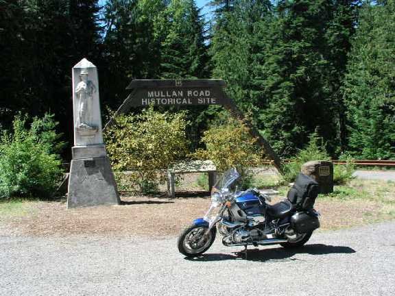
All through the NW MT-Northern ID-NE WA area you will see reference to Mullan Rd and Mullan Trail. While the folks in the East were fighting each other, during 1859-1862 Captain John Mullan of the US Army was establishing a route between Fort Benton, MT and Walla Walla, WA. The goal was to connect the Missouri River and the Columbia River for a supply route. It was marked with ÔÇ£MRÔÇØ for Military Road but this designation is now more commonly described as Mullan Road.
This road was 25 feet wide, ran over 624 miles and hand dug. It was used for over thirty years; then it became part of the motorway designated The Yellowstone Trail (1912-1930s). This was somewhat of a marketing ploy to encourage tourism via a transcontinental highway stretching from MA to WA or ÔÇ£Plymouth Rock to Puget Sound.ÔÇØ This was a private endeavor, similar to the Lincoln Highway project which was started a year after this one and ran parallel but through Midwest states. In the 1930s, as the national highway efforts consolidated all the various routes, this route became Hwy 10. In the 1980s this became part of the Interstate system, now known as I-90.
You can walk on or drive stretches of the Mullan Road, see the old Yellowstone Trail signs and some of the original bridgework still intact across local streams as you leave Montana from Missoula (the frontage road on the north side of I-90) and all the way through the panhandle of Idaho. Stop and visit the historic tree nursery Savenac, I-90 exit 16, Haugen, MT; the road(s) cut through the front yard of the compound. The Mullan Tree monument is off of I-90, exit 28 in Idaho. The crew rested a day because it was July 4, 1861 and blazed a tree with the date. This resulted in the names you see today: Fourth of July Summit, Fourth of July Canyon, Independence Pass, etc. Some of the road can be seen here, too, along the interpretive trail.
Coming from the East: Stop for gas in St. Regis, MT, then take the local road called CamelÔÇÖs Hump, about 15 miles to the other end, where it connects with I-90 again at Harrison. Right now this whole stretch of I-90 is one way each direction and 45 mph due to bridge work so this is actually a faster way to get through the area, although this section of I-90 has incredible sweepers and is normally a sport-bike heaven.
If you have an extra hour or two, instead of CamelÔÇÖs Hump, for a different route, leave St Regis and I-90 behind and take Hwy 135, which follows the Clark Fork River. It is joined by the Flathead River at Hwy 200. Take Hwy 200 to Thompson Falls (or if you are coming across the State on Hwy 200, take note). Just past town, take the bridge to the left, across the river. This road will take you over Thompson Pass and into Idaho.
If you are riding GS and have an extra hour or two, take CamelÔÇÖs Hump to the Harrison end but donÔÇÖt get back on I-90. Instead turn up the forest road to the North (your right), go past the campground, up over Knox Pass towards Thompson Falls. When you come to the bottom you will feel like you just drove out of someoneÔÇÖs backyard, which you have. You will hit the pavement at the same road as the previous paragraph, but you are already across the river from Thompson Falls. Go left on the main road and you can rejoin your pavement-bound buddies (if you separated at St Regis at the same time, you should all join up again here with about the same time traveled) and you can all go over Thompson Pass together.
The road over Thompson Pass was first paved only a few years ago and many maps do not show it as paved or even show the route. When you hit the Y near Prichard you can quickly drop down to Wallace, ID and regain I-90 via a route that is steep, twisty and big time fun, or take the right hand route and meander along the Coeur DÔÇÖAlene River road back to I-90 near Cataldo ID. If you had friends who left St Regis via I-90, they will have had time to eat in Wallace ID while waiting for you to come in the back way.
Chapter Five ÔÇô Go West, Young Man (and Woman)
(see previous posts/pages for Chapters One, Two, Three and Four)
All through the NW MT-Northern ID-NE WA area you will see reference to Mullan Rd and Mullan Trail. While the folks in the East were fighting each other, during 1859-1862 Captain John Mullan of the US Army was establishing a route between Fort Benton, MT and Walla Walla, WA. The goal was to connect the Missouri River and the Columbia River for a supply route. It was marked with ÔÇ£MRÔÇØ for Military Road but this designation is now more commonly described as Mullan Road.
This road was 25 feet wide, ran over 624 miles and hand dug. It was used for over thirty years; then it became part of the motorway designated The Yellowstone Trail (1912-1930s). This was somewhat of a marketing ploy to encourage tourism via a transcontinental highway stretching from MA to WA or ÔÇ£Plymouth Rock to Puget Sound.ÔÇØ This was a private endeavor, similar to the Lincoln Highway project which was started a year after this one and ran parallel but through Midwest states. In the 1930s, as the national highway efforts consolidated all the various routes, this route became Hwy 10. In the 1980s this became part of the Interstate system, now known as I-90.
You can walk on or drive stretches of the Mullan Road, see the old Yellowstone Trail signs and some of the original bridgework still intact across local streams as you leave Montana from Missoula (the frontage road on the north side of I-90) and all the way through the panhandle of Idaho. Stop and visit the historic tree nursery Savenac, I-90 exit 16, Haugen, MT; the road(s) cut through the front yard of the compound. The Mullan Tree monument is off of I-90, exit 28 in Idaho. The crew rested a day because it was July 4, 1861 and blazed a tree with the date. This resulted in the names you see today: Fourth of July Summit, Fourth of July Canyon, Independence Pass, etc. Some of the road can be seen here, too, along the interpretive trail.
Coming from the East: Stop for gas in St. Regis, MT, then take the local road called CamelÔÇÖs Hump, about 15 miles to the other end, where it connects with I-90 again at Harrison. Right now this whole stretch of I-90 is one way each direction and 45 mph due to bridge work so this is actually a faster way to get through the area, although this section of I-90 has incredible sweepers and is normally a sport-bike heaven.
If you have an extra hour or two, instead of CamelÔÇÖs Hump, for a different route, leave St Regis and I-90 behind and take Hwy 135, which follows the Clark Fork River. It is joined by the Flathead River at Hwy 200. Take Hwy 200 to Thompson Falls (or if you are coming across the State on Hwy 200, take note). Just past town, take the bridge to the left, across the river. This road will take you over Thompson Pass and into Idaho.
If you are riding GS and have an extra hour or two, take CamelÔÇÖs Hump to the Harrison end but donÔÇÖt get back on I-90. Instead turn up the forest road to the North (your right), go past the campground, up over Knox Pass towards Thompson Falls. When you come to the bottom you will feel like you just drove out of someoneÔÇÖs backyard, which you have. You will hit the pavement at the same road as the previous paragraph, but you are already across the river from Thompson Falls. Go left on the main road and you can rejoin your pavement-bound buddies (if you separated at St Regis at the same time, you should all join up again here with about the same time traveled) and you can all go over Thompson Pass together.
The road over Thompson Pass was first paved only a few years ago and many maps do not show it as paved or even show the route. When you hit the Y near Prichard you can quickly drop down to Wallace, ID and regain I-90 via a route that is steep, twisty and big time fun, or take the right hand route and meander along the Coeur DÔÇÖAlene River road back to I-90 near Cataldo ID. If you had friends who left St Regis via I-90, they will have had time to eat in Wallace ID while waiting for you to come in the back way.