• Welcome, Guest! We hope you enjoy the excellent technical knowledge, event information and discussions that the BMW MOA forum provides. Some forum content will be hidden from you if you remain logged out. If you want to view all content, please click the 'Log in' button above and enter your BMW MOA username and password.

    If you are not an MOA member, why not take the time to join the club, so you can enjoy posting on the forum, the BMW Owners News magazine, and all of the discounts and benefits the BMW MOA offers?

  • Beginning April 1st, and running through April 30th, there is a new 2024 BMW MOA Election discussion area within The Club section of the forum. Within this forum area is also a sticky post that provides the ground rules for participating in the Election forum area. Also, the candidates statements are provided. Please read before joining the conversation, because the rules are very specific to maintain civility.

    The Election forum is here: Election Forum

Results of Nav V Routes Experiment

BMW Triumphant

Ed Kilner #176066
In a different thread, I promised to do an experiment regarding:
* creating routes in Basecamp, using a profile such as (Motorcycling, Fastest Time) and a second route using a profile such as (Motorcycling, Curvy Roads).

This is a report of my findings.

Creating the routes in Basecamp was more complicated that I expected, because I need more experience with it. At first, it looked like I had Routes A and B (titles were unique) but actually I had the same route twice. Eventually, I duplicated waypoints and made one route display in one colour and the other in another colour so I could see there were two routes.
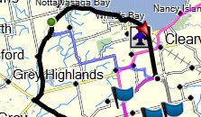
2016-05-17_132835.jpg

Here you can see two routes. One is the black upper loop and the second is the Blue curvy route that splits off the black route near the top left and goes down on a diagonal to the common end point.

So, I sent these to the Nav V using drag and drop to the SD card. Disconnected the Nav V.

Turned on the Nav V, Trip Planner, three-bar menu pushed, import and the Nav V showed the routes on the SD card. Selected them and they imported.

They look as per the Basecamp routes. I could not get the detailed turn-by-turn listing the way I could with Basecamp by double-clicking on the route and looking into the details on the window Basecamp brings up) but it sure looks the same.

OK, I found the detailed steps on the Nav V. Select a route, press Map (above Go) and then the triple-bar menu in upper left. Then select Review Trip in the popup window. They were near identical except the distances were 4.78 in Basecamp and 4.8 in the Nav V, so not significant. And some items had slightly different wording, but I was able to do a one-to-one matching.

When importing was going on, I did not see a splash notice on the Nav V saying "Recalculating", which was a topic in the other forum, the reason why I did the experiment anyway.

Seems a respected writer did two posts about the Nav V and said in one that routes recalculate on import and another that said routes don't recalculate.

I am satisfied that you can generate routes in Basecamp, one with Fastest Time and the other with Curvy Roads, then download both to the Nav V and then choose the one you want when you start your ride and you should be fine.

Have not yet actually ridden one of the routes, but don't expect a problem.

Your comments welcome as always.
 
Here's a question, what settings did the Nav V have when you imported the two routes, i.e., was the navigation mode on the device set to "fastest time", or "curvy roads" etc.? The real question, I suppose, is what would happen if you were to actually navigate these routes on your bike? For example, if you had your Nav V set to "fastest time", and you chose to navigate the "curvy" route, would the GPS at some point re-calculate that route to make it look more like the other one?

The other observation would be your use of the term "recalculate". I think you're referring to two comments from Dan Townsley about the Nav V and you suggest he uses the term "re-calculate" in both of those comments. If I'm not mistaken, he says that a GPS must "calculate" a route on import in order to navigate it (you notice there's no "re" in front of calculate). As I understand it, and his comments, this is different than a device "re-calculating" a route.
 
Last edited:
My understanding of how the Nav works is that it will import and calculate the route according to what you've set in Basecamp. Lest say curvy road. However, if you have it set to a different setting by default, ie shortest route, then, if you wander off the route, it will recalculate to the next waypoint using that setting.
You can minimize the impact by disabling auto recalculate or having lots of waypoints in your route. Disabli.g autorecalculate would require you to zoom out to see where you wandered off and find your way back on route. I prefer adding lots of waypoints.
 
Yes, I did check

Here's a question, what settings did the Nav V have when you imported the two routes, i.e., was the navigation mode on the device set to "fastest time", or "curvy roads" etc.? The real question, I suppose, is what would happen if you were to actually navigate these routes on your bike? For example, if you had your Nav V set to "fastest time", and you chose to navigate the "curvy" route, would the GPS at some point re-calculate that route to make it look more like the other one?

The other observation would be your use of the term "recalculate". I think you're referring to two comments from Dan Townsley about the Nav V and you suggest he uses the term "re-calculate" in both of those comments. If I'm not mistaken, he says that a GPS must "calculate" a route on import in order to navigate it (you notice there's no "re" in front of calculate). As I understand it, and his comments, this is different than a device "re-calculating" a route.

I realized after I did the post that I needed to check the setting - Profile was Motorcycle, Fastest Time.

Also, I am a long way from my house, the start point of the routes. I pressed the GO button and was asked where the next stop was to be, said home, and the route recalculated to get me there. Sure looked like all the rest of the route was unchanged, I think the route would be respected, even if I made some detour and returned to the route but can't be sure.

Still, I am reassured.

I think these items also address the calculation/loading and re-calculation issues.
 
Agreed

My understanding of how the Nav works is that it will import and calculate the route according to what you've set in Basecamp. Lest say curvy road. However, if you have it set to a different setting by default, ie shortest route, then, if you wander off the route, it will recalculate to the next waypoint using that setting.
You can minimize the impact by disabling auto recalculate or having lots of waypoints in your route. Disabli.g autorecalculate would require you to zoom out to see where you wandered off and find your way back on route. I prefer adding lots of waypoints.

Lots of waypoints also gives a nicer ride! I don't often deviate from a route, but sometimes in the second season (=Roadwork Season), the choice is not mine!

Could that lose a curvy section? Maybe. Does that suggest the default setting for the system be Motorcycle, Curvy? I am not sure. Some previous experiments with Curvy in my rather rectangular road area gave me l-o-n-g-e-r routes.

:) :scratch
Yes, curvy sometimes gets you funny results. I set mine to fastest by default.
 
I was riding a route I had made in Basecamp and exported to the Nav V. I decided to go a different way, so I missed a waypoint. The Nav V kept tying to reroute me back to the missed waypoint. Extremely irritating. How can that be avoided?
 
I was riding a route I had made in Basecamp and exported to the Nav V. I decided to go a different way, so I missed a waypoint. The Nav V kept tying to reroute me back to the missed waypoint. Extremely irritating. How can that be avoided?

You can always just hit a "button" to skip a waypoint. It works very well. In fact, I make this "button" one of the two that you can add to your map page onscreen display, though it will only appear when you're actually navigating a route. The other button I have on there is weather radar.
 
Last edited:
A fellow by the name of Dan Townsley has been mentioned in this, and other, Nav V threads. He is a guide with GlobeRiders, has an extensive technology background, and has written a number of articles on GPSs, including the Nav V. He also posts frequently on forums, usually providing answers to people's questions. I thought these two excerpts (below) from a couple of his posts were pertinent to this discussion.

The first:

"I see this question so many times that I thought it would be good to discuss it again in a separate thread.

The short answer to the question is, you cannot stop a GPS from calculating a GPX Route - it has to.

There is no such thing as “turning off route calculation.” There is no ‘line’ in your GPX Route data that the GPS can just draw on the map.

Some folks confuse the setting, Route Recalculation = ON/OFF, found in many GPS devices with the ability to avoid changing their original route path when the GPS first reads the Route data. ‘Route Recalculation = ON/OFF’ only effects what the GPS does when you leave the route path while navigating an active Route.

When using Routes on a GPS, the objective is to get the GPS to calculate the route path the same as it was calculated in your planning software.

So, how do we achieve our GPS Routing objective? Like most things, there’s a short and a long answer. The short answer is, just add more points (Waypoints, Via Points, ShapingPoints) to your Route when you create it. But, now the long answer comes in to play.

You need to know what your GPS Route Point limitations are. Some older Garmin devices and most Garmin Handheld devices can have up to 50 Route Points. Most newer Garmin GPS devices can only use 30 Route Points (Via Points, Waypoints) in a Route. But, these newer devices can use a hundred or more ShapingPoints between the Via Points.

If you use Garmin’s MapSource or BaseCamp software, they can create Routes that include ShapingPoints. But, even though BaseCamp can determine what Garmin device is connected to the computer, BaseCamp (or MapSource) will not keep you from adding to many points (of any kind) to a Route. This in my opinion is a serious shortcoming of BaseCamp. Garmin has decided to leave this critical decision up to the user - even though they could easily manage this within BaseCamp.

So, there you have it. There is no such thing as keeping your Route from being ‘recalculated’ when you send/copy it to your GPS. All Route’s must be calculated."


The second:

"...when you Import a Route to the Trip Planner the GPS MUST calculate that Route - and it uses YOUR Navigation Settings."
 
Last edited:
I was riding a route I had made in Basecamp and exported to the Nav V. I decided to go a different way, so I missed a waypoint. The Nav V kept tying to reroute me back to the missed waypoint. Extremely irritating. How can that be avoided?

When you design the route in Basecamp, anything set to "alert on arrival" is a waypoint and if you get off your route, the Nav will try and make you go through it. Anything set to "do not alert on arrival' is a shaping point and you can skip those. It's kind of like waypoints are "must do" and shaping points are "nice to do." (I think on a PC you change that setting by right clicking a point; on a Mac you ctrl-click it).

Given that, I only make every fifth or sixth point and scheduled fuel or pit stops waypoints and the rest shaping points. But as pointed out, you can go into the route and delete a specific waypoint but it takes a bit of effort.


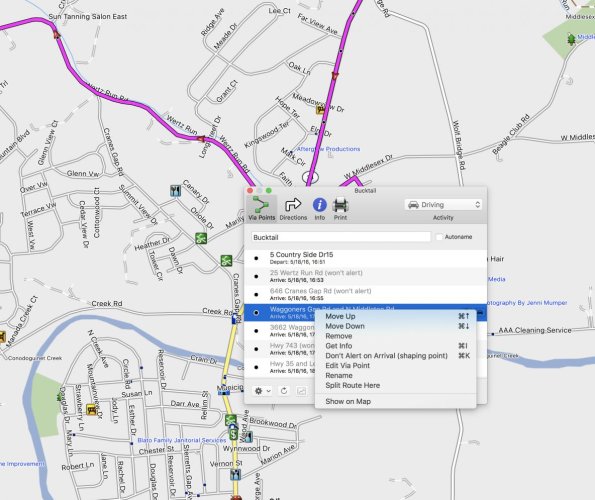
Screen Shot 2016-05-18 at 16.52.42.jpg
 
When you design the route in Basecamp, anything set to "alert on arrival" is a waypoint and if you get off your route, the Nav will try and make you go through it. Anything set to "do not alert on arrival' is a shaping point and you can skip those. It's kind of like waypoints are "must do" and shaping points are "nice to do." (I think on a PC you change that setting by right clicking a point; on a Mac you ctrl-click it).

Given that, I only make every fifth or sixth point and scheduled fuel or pit stops waypoints and the rest shaping points. But as pointed out, you can go into the route and delete a specific waypoint but it takes a bit of effort.


View attachment 56452

I agree with everything you said, and they're very good suggestions. I would only add that, with the newer devices (like a Nav V), you don't actually have to go into the route to delete a waypoint. You can simply touch an onscreen icon/button while you're riding along navigating a route. One touch and "poof", it's deleted.
 
The second:

"...when you Import a Route to the Trip Planner the GPS MUST calculate that Route - and it uses YOUR Navigation Settings."

I think the nav settings referred to are the ones in the Nav V unit and not the settings in the route created in Basecamp.

But, I was able to create a route using Curvy Roads in Basecamp, send it to the Nav V and see that the curvy part was preserved. As I said in a previous post, I activated the route from a different starting point, an additional leg was added to get me to the original starting point, but the unique curvy part at the end of the route was preserved.

So, that is against the quote?

I'm going to have to investigate further and will post again.

You know, things might be changing with updates to the Nav V, Basecamp or both.
 
Or, maybe you had enough points in your route, when created, that it didn't matter what the settings were on your Nav V (I couldn't really tell from the graphic in your original post). I don't seem to have any problems having my Nav V navigate a route as I laid it out in Basecamp, but then again I always have a reasonable number of points in them (waypoints and shaping points).
 
Or, maybe you had enough points in your route, when created, that it didn't matter what the settings were on your Nav V (I couldn't really tell from the graphic in your original post). I don't seem to have any problems having my Nav V navigate a route as I laid it out in Basecamp, but then again I always have a reasonable number of points in them (waypoints and shaping points).

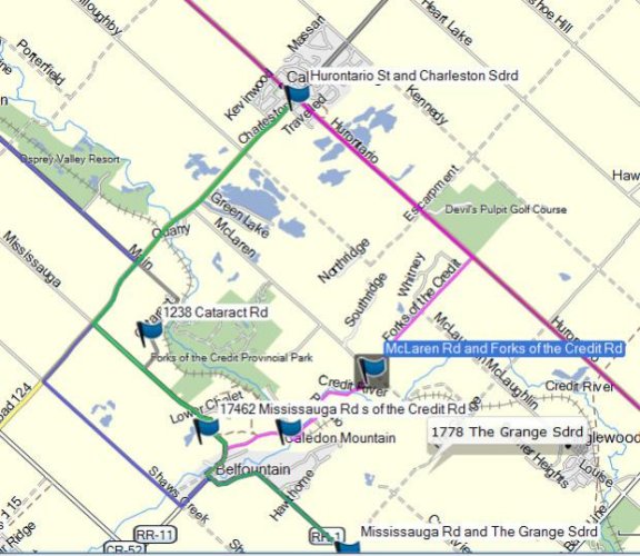
2016-05-18_222200.jpg

OK, here are 3 routes. Two use only the same start and end point. The third uses an additional waypoint to go through a switchback (there are very few of those in Southern Ontario!). Called Fastest, Shortest, Curvy.

The Nav V is set to Fastest internally.

Transferred all three to the Nav V, and all three were recalculated from a far away point where I am to the same start point. This would give the Nav V all kinds of availability to use the internal calculations ie Fastest.

All 3 routes as made in Basecamp were respected.

As soon as I can finish replacing the slightly worn cedar planking in my huge poolside deck, I will be able to go riding! At least a week away, maybe more, but I will do these routes and report back.

I am going to see the help file in Basecamp re: Via points. Supposedly, I should be able to change the added waypoint to a via but right clicking it does not give me a screen to do that. Maybe this is a Nav V option only? I will figure it out eventually.

Edit: Basecamp Help search for Via Point turned up zero. Other searching around revealed the reference to "points" not waypoints, not via points. Comments welcome
 
Last edited:
View attachment 56454

OK, here are 3 routes. Two use only the same start and end point. The third uses an additional waypoint to go through a switchback (there are very few of those in Southern Ontario!). Called Fastest, Shortest, Curvy.

The Nav V is set to Fastest internally.

Transferred all three to the Nav V, and all three were recalculated from a far away point where I am to the same start point. This would give the Nav V all kinds of availability to use the internal calculations ie Fastest.

All 3 routes as made in Basecamp were respected.

As soon as I can finish replacing the slightly worn cedar planking in my huge poolside deck, I will be able to go riding! At least a week away, maybe more, but I will do these routes and report back.

I am going to see the help file in Basecamp re: Via points. Supposedly, I should be able to change the added waypoint to a via but right clicking it does not give me a screen to do that. Maybe this is a Nav V option only? I will figure it out eventually.

Edit: Basecamp Help search for Via Point turned up zero. Other searching around revealed the reference to "points" not waypoints, not via points. Comments welcome

Hey, I learned something else today. I checked regarding Waypoints and Viapoints in Basecamp. It seems any points you create is a Waypoint but becomes a Viapoint when you use them in a route. Open the route and right click on the waypoint. The menu will show Edit Viapoint.
 
Hey, I learned something else today. I checked regarding Waypoints and Viapoints in Basecamp. It seems any points you create is a Waypoint but becomes a Viapoint when you use them in a route. Open the route and right click on the waypoint. The menu will show Edit Viapoint.

Not quite, but we are all learning things.

The route details sheet has a tab that is titled Via Points
. They do it to confuse us. :banghead

But the symbol is the standard waypoint symbol, and the Edit Viapoint dialog does not allow you to do much except enter times, if I recall.

However, you can create a real via point that shows up as a blue dot, quite small and easy to miss, using the Insert feature. When you do this, the detail page will say the point is not announced or some such thing.

The insert button looks like a pencil. After pressing it, you move the cursor, now a pencil, over the route and sections between two waypoints will have a black line visible. Click on the route and a rubber band line will form. Drag the rubber band to some place/intersection and click, move to another place and click until you have shaped the route the way you want.

Check the details page and you will see you have added Via points, not waypoints.

Learned this last night. And, using Insert might take a bit of practice, it sure looked to me like it was not working at first. But, then I figured it out. Let me know if this helped.
 
Yes, you need to use LOTS of waypoints. My Nav V will take off after the slightest sniff of a toll road. It dumped me into Washington DC at 5 in the afternoon when I thought I was navigating well clear. Carry a map and check it!
 
Back
Top