sfarson
New member
Ever find yourself with an unplanned afternoon open? Probably Have. Yesterday I was jilted by my wife (a planned lunchtime ride), as she chose to visit with a friend instead. Well all righty then!
Perhaps the second question is... Ever just wander a general direction on the bike not really knowing where you will end up or how far you will ride? So I head one direction, ride for an hour, get a snack, ponder life, go farther from home for another hour, go to the bathroom, ponder life, look at the blue skies, and say "Let's go for it." Roads and back country never seen. May not make it home in time for din. Payback for the jilt") .
.
It was in Buena Vista, Colorado (map below) I decided to head for Cottonwood Pass (paved on the east, dirt on the west). Have never been down the dirt side, seeing the views, wilderness, semi-ghost towns, etc. First the map, then pics will tell most of the story...

Cottonwood Pass looking towards the east (paved side)...

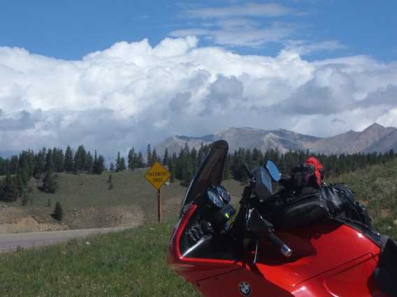
Looking to the west...

And the road taking me there...

Made it to Taylor Park Reservoir. The blues below and above are competing for attention...

Passing through the small, semi-ghost town of Tincup, on the way to Cumberland Pass...

In 1906 it looked this way. Had I planned things I could have tried to find where the photographer stood and taken a "then and now" image. One can see the newly finished Town Hall (also in photo above) I'm coming in from the right side of the image. Many more trees in the surrounding hills/mountains now. Not cut down for housing or heat as was common 100 years ago...

Paused at some beaver ponds but the image didn't turn out. Lonely ride. Don't see anyone coming or going. No one knows I'm here. No cell coverage. What if the bike breaks. Steve, why do you do this. Oh the things bouncing between the ears as one goes higher, deeper, and farther...

At Cumberland Pass. Road became quite rocky between the top of the pass and previous pic. But the '01 GS comes through fantastically. From where we came, the climb, and looking to the northwest. Wilderness as far as one can see...

Looking to the east. Kinda nice knowing there is still vast swaths of wilderness in the lower 48...

The ground on the pass almost looks like Mars. The sky is all Earth...

After a few switchbacks, one comes across one of the larger mines I've been seeing in the area. We're above 10,000ft. here. This is the Bon Ton mine. Hundreds of inches of snow annually are taking their toll on the seven or so cabins and structures in the area. Can't imagine living here year round...

Down around 8500ft. I come across a reminder that a change of seasons is upon us, including the autumnal razor blue sky...

Pavement returns at Pitken. Paused for a pic...

And how the neighbors looked in 1905 in front of one of the buildings I have in the above pic...

The setting sun has me on Monarch Pass, looking to the north...

An impromptu day of memories with the BMW not leaving me stranded, and my wife still loving me after my 8:00p arrival at home .
.
Perhaps the second question is... Ever just wander a general direction on the bike not really knowing where you will end up or how far you will ride? So I head one direction, ride for an hour, get a snack, ponder life, go farther from home for another hour, go to the bathroom, ponder life, look at the blue skies, and say "Let's go for it." Roads and back country never seen. May not make it home in time for din. Payback for the jilt
.It was in Buena Vista, Colorado (map below) I decided to head for Cottonwood Pass (paved on the east, dirt on the west). Have never been down the dirt side, seeing the views, wilderness, semi-ghost towns, etc. First the map, then pics will tell most of the story...
Cottonwood Pass looking towards the east (paved side)...
Looking to the west...
And the road taking me there...
Made it to Taylor Park Reservoir. The blues below and above are competing for attention...
Passing through the small, semi-ghost town of Tincup, on the way to Cumberland Pass...
In 1906 it looked this way. Had I planned things I could have tried to find where the photographer stood and taken a "then and now" image. One can see the newly finished Town Hall (also in photo above) I'm coming in from the right side of the image. Many more trees in the surrounding hills/mountains now. Not cut down for housing or heat as was common 100 years ago...
Paused at some beaver ponds but the image didn't turn out. Lonely ride. Don't see anyone coming or going. No one knows I'm here. No cell coverage. What if the bike breaks. Steve, why do you do this. Oh the things bouncing between the ears as one goes higher, deeper, and farther...
At Cumberland Pass. Road became quite rocky between the top of the pass and previous pic. But the '01 GS comes through fantastically. From where we came, the climb, and looking to the northwest. Wilderness as far as one can see...
Looking to the east. Kinda nice knowing there is still vast swaths of wilderness in the lower 48...
The ground on the pass almost looks like Mars. The sky is all Earth...
After a few switchbacks, one comes across one of the larger mines I've been seeing in the area. We're above 10,000ft. here. This is the Bon Ton mine. Hundreds of inches of snow annually are taking their toll on the seven or so cabins and structures in the area. Can't imagine living here year round...
Down around 8500ft. I come across a reminder that a change of seasons is upon us, including the autumnal razor blue sky...
Pavement returns at Pitken. Paused for a pic...
And how the neighbors looked in 1905 in front of one of the buildings I have in the above pic...
The setting sun has me on Monarch Pass, looking to the north...
An impromptu day of memories with the BMW not leaving me stranded, and my wife still loving me after my 8:00p arrival at home
.
Last edited:

 ). Great pics and report
  thanks for sharing it.