• Welcome, Guest! We hope you enjoy the excellent technical knowledge, event information and discussions that the BMW MOA forum provides. Some forum content will be hidden from you if you remain logged out. If you want to view all content, please click the 'Log in' button above and enter your BMW MOA username and password.

    If you are not an MOA member, why not take the time to join the club, so you can enjoy posting on the forum, the BMW Owners News magazine, and all of the discounts and benefits the BMW MOA offers?

  • Beginning April 1st, and running through April 30th, there is a new 2024 BMW MOA Election discussion area within The Club section of the forum. Within this forum area is also a sticky post that provides the ground rules for participating in the Election forum area. Also, the candidates statements are provided. Please read before joining the conversation, because the rules are very specific to maintain civility.

    The Election forum is here: Election Forum

Badger lake, oregon

chasmrider

not lost til out of gas
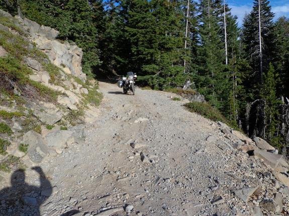
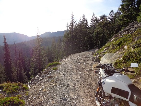
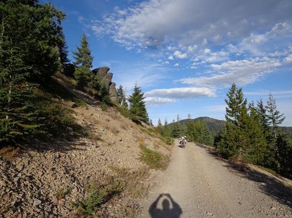
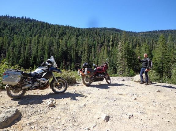
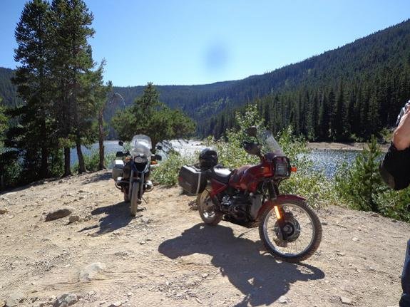
hey everyone, I was in the Mt Hood national forest, and thought I would ride up to Badger lake. there were a lot of forks in the road, and I think I took the wrong one somewhere. so I never found Badger lake, I turned around when the road turned into a narrow, steep, uphill, side hill, rock garden, that looked like it was getting worse. also I was by myself and it was 17:00. here are a couple of pictures. it is supposed to snow up there next week, so maybe next year I will find the elusive Badger lake.
 

Attachments

  • dsc00870 A.jpg
    dsc00870 A.jpg
    71.4 KB · Views: 169
  • dsc00868 A.jpg
    dsc00868 A.jpg
    151.1 KB · Views: 167
Looks familiar although my experience is not with Badger Lake but with the NF NW of Morton, WA. 30 yrs ago I rode a Honda XL 250 in this NF and it was great - nice gravel, graded roads, etc. Now there's no logging in this NF and the roads - if you can call them that - are bare bedrock or creek beds. Like you we got a late start and got too far into the NF and had to inadvertently spend the night. It was just too dangerous to drive these roads in the dark. I didn't realize the road side was washed out and almost dropped 60' down through the woods. So we just "camped" right there with what gear we had - no sleeping bags or tent. Next morning we realized the road we were on became so overgrown with "peckerpole" alders it was impassible. Although I had a map and GPS it took hours to find our way out because most roads were washed out or blocked. It was an experience! You could tell that few if any folks ventured up into this NF.The trick was to find the roads that were used even if sparsely used. This "short" ride became an endurance test of rider and machine.

Now I look at topo maps and roads in greater detail. Some topo maps of USFS areas have a road condition by the way the NF road number is displayed. If the road number is vertical it means high clearance/4WD. If the road number is displayed horizontally it means 2WD vehicle. Secondly review the Alerts, Warnings and Road Conditions published per NF district on the NF website. Most of the time it will tell you of washouts, blockages, or other conditions.

Finally, do not depend on Google Maps - they're wrong a lot. Use an app like Avenza PDF Maps or Trimble Maps and download the appropriate topo map or maps for the area you want to explore.
-don
 
Last edited:
thanks Don, good info, although in the Mt Hood NF I do it a little different. since this is essentially my backyard, I have 360 mi range, it's hard to get more than 50 mi from a gas station, and I am familiar with the area, I like to go out and ride new roads, then look at the map and see where I went when I get home. what holds me back most, I always seem to be alone. after looking at google earth I now believe I was on the right road. here is why, I searched, Mt Hood NF, in google earth and it took me to Timberline lodge, then east to hwy 35 then nf 48, continue e on the 48 to 4890 then n to 4891. 4891 starts the offroad portion. as you go up the 4891 past Bonney meadows, the road is now called Bennet pass rd. on that roar I passed some rocks which you can easily see. here is a picture of those rocks. if you follow that road you will see a big scree field ( big rock slide) that is where I turned around and took some pictures. ( my original post )
just past the scree, there is another road down to Badger lake, so I was almost there.
 

Attachments

  • dsc00874 A.jpg
    dsc00874 A.jpg
    55 KB · Views: 132
elusive Badger lake

hey everyone, I can now say I have been to Badger lake! my friend and I rode up there a month or so ago. I was on my street bike so we took the car road. ( not much of a road really ) it was ok til we got to the cutoff, mostly gravel/dirt, some rocks. the road down is pretty sketch. It is about a 15% grade cut into the side of the mountain, just china rocks, and smaller rocks, with about a 500 foot dropoff, straight down. I wasn't very happy going down,( it is probably a quarter mile or so, but seemed much longer ) however going up was no problem, and on the way home I was thinking, that was fun! so here are a couple of pictures.
 

Attachments

  • DSC00942a.jpg
    DSC00942a.jpg
    57.9 KB · Views: 81
  • DSC00943a.jpg
    DSC00943a.jpg
    56.5 KB · Views: 81
hey everyone, I can now say I have been to Badger lake!

Congratulations!

I rode through that area on the way home from the 2013 Rally in Salem. The photo below was taken on "the other Lolo Pass"... along the western slope of Mt. Hood, which was an adventure detour for the GS Giant event that year.

Beautiful stuff, however, the fact that these are volcanoes makes me wince a little. I guess you just put that out of your mind if you live out there. :eek

IMG_2715-XL.jpg


<iframe src="//ridewithgps.com/routes/2759976/embed" height="800px" width="100%" frameborder="0"></iframe>
 
Close but no...

I was riding home from the BMWRO Steens-Narrows Campout and remembered the post about Badger Lake. The issue was I was on my '06 R1200RT not my GS and I was riding solo. I can handle good gravel easily on my RT but more challenging stuff is better left to my GS. I was feeling some swagger as I breezed through 0.5 miles of very rough road construction out of Tygh Valley on the Wamic Market Road. When I stopped at the intersection of Badger Lake Rd and USFS 48, a Toyota Landcruiser met me and advised against me riding there. Again since I was solo and I could hear my wife's voice in my head - 'You crash that and you'll not get another one." So I deferred. Great views of Mt. Hood from USFS 48 though. And a nice alternative versus US 26 or US 197. Guess I'll have to try another time.
20150914_094839.jpg
 
Back
Top