texanrt
New member
A ride to Galveston to see the clean up
I haven't been back to Galveston since before Thanksgiving and wanted to see how the clean up is progressing. While there's still lots of clean up ahead, there's been significant progress. Mountains of debris have been removed when compared to my first ride through following the storm. The area around where this first pic was taken sustained heavy damage from the surge -- many buildings are gone. This boat came to rest about 100 yards from its mooring -- there would have been a building between the camera and the boat in this pic but it's no longer there.

This is where I often stopped to tank up before heading back to Houston on my frequent trips down to the beach. This gas station was still standing after the storm but was completely gutted and only the shell of the building remained -- now it's a nice pile of debris waiting to be removed.

One of the island's destinations was back open for business -- The Spot serves some great burgers right on Seawall Blvd.

The historic Strand district was hit by the storm surge -- here you can make out a blue line across the building marking the surge height. A few businesses were open yesterday, but many remain shuttered.

A few boats remain laying around the island, but many more have been moved.

This marina sustained heavy damage -- in addition to the collapsed building seen here, another dry storage building full of boats burned to the ground during the storm, the fire department unable to get to it because the streets were flooded.

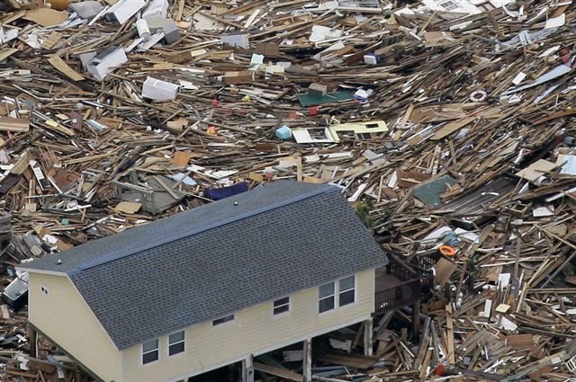
Lots of debris remains around the island -- here's a pic from the east end near the ship channel where a bobcat is busy clearing the flotsam. On my first trip down after the storm this beach was covered with rubbermaid products washed out of people's homes -- you could have stocked a Wal Mart with all the storage containers washed up here. There were still people picking through the debris yesterday, but all the "good" stuff is gone.

Lots of beach restoration going on across the island. Here they're digging up sand in one spot....

.... to deposit it here about a mile further down the beach.

The famous Galveston Balinese Room is gone.

All that remains are some of the old broken pilings and this placard indicating its historic registry.

What's left of the old souvenir shops between the Balinese and the Flagship hotel.

This concrete fishing pier took a real beating -- three people were rescued by helicopter from the roof of the caretaker's apartment - they tried to ride out the storm and were afraid the apartment would eventually go down with the pier. None of the pier's decking remains and about 100' of the pier is completely gone.


Beyond the seawall, there is extensive erosion. You can see by the hydrant and manhole pictured how much sand is gone. Even the road was undermined by the wave action -- something I didn't notice until I was walking back to the bike.

More effects of erosion along the beach front properties. They've already started moving sand back under these houses.

The surge and wave action removed several feet of beach as far as I could see.

At the far western end of Galveston Island is San Luis pass -- popular with fishermen. If the fish aren't biting, strap a lawnmower engine to your back and go flying.

When the pilot noticed me stopped along the San Luis pass bridge, he turned my way for a photo op.

Beyond San Luis pass is the "Blue Water" highway that goes to Surfside and Freeport. The road was breached in several places within a few miles of the San Luis pass bridge just beyond Galveston Island. A temporary gravel road crosses here where about 100' of road was washed away.

I haven't been back to Galveston since before Thanksgiving and wanted to see how the clean up is progressing. While there's still lots of clean up ahead, there's been significant progress. Mountains of debris have been removed when compared to my first ride through following the storm. The area around where this first pic was taken sustained heavy damage from the surge -- many buildings are gone. This boat came to rest about 100 yards from its mooring -- there would have been a building between the camera and the boat in this pic but it's no longer there.
This is where I often stopped to tank up before heading back to Houston on my frequent trips down to the beach. This gas station was still standing after the storm but was completely gutted and only the shell of the building remained -- now it's a nice pile of debris waiting to be removed.
One of the island's destinations was back open for business -- The Spot serves some great burgers right on Seawall Blvd.
The historic Strand district was hit by the storm surge -- here you can make out a blue line across the building marking the surge height. A few businesses were open yesterday, but many remain shuttered.
A few boats remain laying around the island, but many more have been moved.
This marina sustained heavy damage -- in addition to the collapsed building seen here, another dry storage building full of boats burned to the ground during the storm, the fire department unable to get to it because the streets were flooded.
Lots of debris remains around the island -- here's a pic from the east end near the ship channel where a bobcat is busy clearing the flotsam. On my first trip down after the storm this beach was covered with rubbermaid products washed out of people's homes -- you could have stocked a Wal Mart with all the storage containers washed up here. There were still people picking through the debris yesterday, but all the "good" stuff is gone.
Lots of beach restoration going on across the island. Here they're digging up sand in one spot....
.... to deposit it here about a mile further down the beach.
The famous Galveston Balinese Room is gone.
All that remains are some of the old broken pilings and this placard indicating its historic registry.
What's left of the old souvenir shops between the Balinese and the Flagship hotel.
This concrete fishing pier took a real beating -- three people were rescued by helicopter from the roof of the caretaker's apartment - they tried to ride out the storm and were afraid the apartment would eventually go down with the pier. None of the pier's decking remains and about 100' of the pier is completely gone.
Beyond the seawall, there is extensive erosion. You can see by the hydrant and manhole pictured how much sand is gone. Even the road was undermined by the wave action -- something I didn't notice until I was walking back to the bike.
More effects of erosion along the beach front properties. They've already started moving sand back under these houses.
The surge and wave action removed several feet of beach as far as I could see.
At the far western end of Galveston Island is San Luis pass -- popular with fishermen. If the fish aren't biting, strap a lawnmower engine to your back and go flying.
When the pilot noticed me stopped along the San Luis pass bridge, he turned my way for a photo op.
Beyond San Luis pass is the "Blue Water" highway that goes to Surfside and Freeport. The road was breached in several places within a few miles of the San Luis pass bridge just beyond Galveston Island. A temporary gravel road crosses here where about 100' of road was washed away.
Last edited: