•  

    Welcome! You are currently logged out of the forum. Some forum content will be hidden from you if you remain logged out. If you want to view all content, please LOG IN!

    If you are not an MOA member, why not take the time to join the club, so you can enjoy posting on the forum, the BMW Owners News magazine, and all of the benefits of membership? If you click here, you have the opportunity to take us for a test ride at our expense. Enter the code 'FORUM25' in the activation code box to try the first year of the MOA on us!


Navigation suggestions

jharpphoto

Member
I'm in the "research" phase of a new navigation unit for my 2024 RT. I don't have the connectivity issues that many experience w/ the BMW connnected app luckily. I am considering a stand alone nav unit however and know many like the Garmin Zumo. I would be interested in hearing suggestions from you on Nav units. The Zumo looks pretty cool to me but I'm sure there are many others to consider. Any suggestions would be much appreciated.
 
I use MyRoute.app with the ConnectedRide.App and device…it took a little figuring out - I came from Basecamp and a garmin 396..this system is superior.
 
Garmin zumo XT. You have a choice of applications to create and manage your routes or tracks. Free ones free versions of ones and others that require a subscription or a one time fee.
If you've never used a gps, to get the best results, take the time to learn what it can do, what gotchya, what limitations. There are good tutorials out there.
I use Basecamp as it's free, uses the same maps I have on the zumo and have been using it for years.
MyRouteApp is as close to what Basecamp does but with an easier interface. For best results get the subscription.
 
I am intrigued by the Capuride products that use wireless CarPlay or Android Auto, especially for a unit that would be used on a road bike like the RT. Less $$ than the Garmin, Google maps are updated constantly, and no Garmin learning curve or software issues. And, hotel/restaurant locations and info are more up to date.

Best,
DeVern
 
Your decision comes down to what sort of navigation you need.

If you only want the quickest or shortest way between A and B and aren't going to be out of cell/wifi service when initiating a route, then Google Maps on your cell phone may suffice. You can embellish this with a Capuride or other unit via Carplay/AndroidAuto if you want to keep your phone out of the elements.

If you want to plan specific routes, that are not necessarily the quickest/most direct way, then Google Maps will not suffice. Your options then include ConnectedRide, Garmin XT or XT2 or one of a few cell phone based navigation apps.

ConnectedRide does not support non-announcing shaping points, which in of itself is a deal breaker for me. But, if you do some googling around, you'll also find many have no end of connection problems between the required cell phone and the head unit, especially with Apple.

Garmin XT and XT2 are purpose built for motorbike navigation and though they can support simple A to B navigation, they excel at plotting out complex routes where you can choose exactly what roads to travel. Both support non-announcing shaping points. If you are a Basecamp hold out, the XT is for you, as the XT2 does not directly integrate with Basecamp. You can use 3rd party apps like MyRouteApp to route plan as well for either, but the XT2 was designed to use route plan directly on the XT2 or via Garmin's free Tread app on your phone with routes then cached in the Cloud. Garmin's synch to the Cloud process seems to corrupt routes on occasion.

No nav system is 100% perfect.

In the event it might not have been apparent from the above, I use the XT/XT2 for 99% of my navigation and Google Maps from directly on my phone for the occasional in town navigation needs. I ride too much in remote areas with little or no cell service and in temp extremes that cause the phone to lockup or shutdown to rely on any cell phone dependant nav system. I also need the nav for the complex routes I've plotted out which rules out Google Maps and ConnectedRide. Only you know what your needs are, which could differ greatly from my needs or that of others.
 
Thanks for this insightful info Bob. Sounds like the XT2 may be in my future.


Your decision comes down to what sort of navigation you need.

If you only want the quickest or shortest way between A and B and aren't going to be out of cell/wifi service when initiating a route, then Google Maps on your cell phone may suffice. You can embellish this with a Capuride or other unit via Carplay/AndroidAuto if you want to keep your phone out of the elements.

If you want to plan specific routes, that are not necessarily the quickest/most direct way, then Google Maps will not suffice. Your options then include ConnectedRide, Garmin XT or XT2 or one of a few cell phone based navigation apps.

ConnectedRide does not support non-announcing shaping points, which in of itself is a deal breaker for me. But, if you do some googling around, you'll also find many have no end of connection problems between the required cell phone and the head unit, especially with Apple.

Garmin XT and XT2 are purpose built for motorbike navigation and though they can support simple A to B navigation, they excel at plotting out complex routes where you can choose exactly what roads to travel. Both support non-announcing shaping points. If you are a Basecamp hold out, the XT is for you, as the XT2 does not directly integrate with Basecamp. You can use 3rd party apps like MyRouteApp to route plan as well for either, but the XT2 was designed to use route plan directly on the XT2 or via Garmin's free Tread app on your phone with routes then cached in the Cloud. Garmin's synch to the Cloud process seems to corrupt routes on occasion.

No nav system is 100% perfect.

In the event it might not have been apparent from the above, I use the XT/XT2 for 99% of my navigation and Google Maps from directly on my phone for the occasional in town navigation needs. I ride too much in remote areas with little or no cell service and in temp extremes that cause the phone to lockup or shutdown to rely on any cell phone dependant nav system. I also need the nav for the complex routes I've plotted out which rules out Google Maps and ConnectedRide. Only you know what your needs are, which could differ greatly from my needs or that of others.
 
I'm in the "research" phase of a new navigation unit for my 2024 RT. I don't have the connectivity issues that many experience w/ the BMW connnected app luckily. I am considering a stand alone nav unit however and know many like the Garmin Zumo. I would be interested in hearing suggestions from you on Nav units. The Zumo looks pretty cool to me but I'm sure there are many others to consider. Any suggestions would be much appreciated.
After using three dedicated Garmin units on my 2003 R1150 RT over the years, I am in the process of removing that mount and switching to QuadLock and my own phone. The Zumo XT unit I bought a couple of years ago has become unnecessary as my phone is superior in all ways. Plus, the device still requires (mini USB!?@#$) wired software updates despite Wi-Fi capability, the screen scratches much more easily than its predecessor, and has caused interoperability issues between my Schuberth C5 and phone. Time to remove the one disappointing link in the chain.

A riding buddy also removed a much older Garmin from his 2006 R1200 RT in favor of the QuadLock system and his own phone last summer and is very happy with the change.

Hope this helps.
 
I will offer a somewhat contrarian view! If you live and/or ride most of the time where cell phone coverage is reliable then a phone based system will work. If your phone has the ability to hold pre-downloaded maps in sufficient quantity and you enjoy massaging the map system you may be good anyway. Where I live it is 25 miles one direction or 50 miles the other direction to reach cell phone coverage. And in my 600 miles ride or drive to leave Texas from where we live, more than 50% of the distance lacks cell phone coverage.

Also I have never used much of my GPS's features. I seldom do routes and usually just enter a destination with a couple of waypoints for a full day's ride.

Thus we have aging Garmin Zumo 660 (similar to BMW Nav4) units in the car and on both my bike and Voni's bike. This is a no fuss solution which displays all the information I want in the format I want to see it. I have no need to manage preloaded maps. Over the past 35 years of using Garmin GPS I have accumulated over 300 personal waypoints, not counting the several in Africa and New Zealand, which along with the use of cities or towns by name and their included attractions permits me to shape almost any single day or mutli-day trip.

When I get into a city or town or other location where I need more detail or more up-to-date information I can usually supplement information using my cell phone: this assuming I have cell phone service.

I surrender to the notion that this is a neanderthal (no genetic offense intended) or Luddite approach but I have been using a GPS since well before the US Government stopped distorting the signals for national security purposes and it works for me. I do have Google Maps, Mapquest, Waze, My GPS Coordinates, Harvest Hosts, National Park Service, CBP Roam, Great River Road, and a half dozen hotel/motel apps loaded on my iPhone if I need or wish to use them. And Voni has a bunch more too.:)

But for most situations the Garmin 660 on the left handlebar, a Garmin V showing a data table on the right handlebar, and a map in the tankbag pocket is all I use for navigation. There was the time in the Ozarks when I missed a turn in town on a double letter road. After I figured that out Voni's retort was, "Two GPSs and a map and you still got lost" but that is another story.

And yes, I know for sure, YMWV.
 
Last edited:
I am intrigued by the Capuride products that use wireless CarPlay or Android Auto, especially for a unit that would be used on a road bike like the RT. Less $$ than the Garmin, Google maps are updated constantly, and no Garmin learning curve or software issues. And, hotel/restaurant locations and info are more up to date.

Best,
DeVern
You probably want the Chigee devices. A friend has had a string of Maxca, Capuride and now a Chigee. The recent device has CarPlay, reliably connects to his helmet and phone and you can use your WonderWheel to navigate CarPlay.

I've been holding out, but the Chigee may finally deliver what we need. A couple other friends are running them as well and are satisfied with them.
 
I will offer a somewhat contrarian view! If you live and/or ride most of the time where cell phone coverage is reliable then a phone based system will work. If your phone has the ability to hold pre-downloaded maps in sufficient quantity and you enjoy massaging the map system you may be good anyway. Where I live it is 25 miles one direction or 50 miles the other direction to reach cell phone coverage. And in my ride or drive to leave Texas from where we live, more than 50% of the distance lacks cell phone coverage.

Also I have never used much of my GPS's features. I seldom do routes and usually just enter a destination with a couple of waypoints for a full day's ride.

Thus we have aging Garmin Zumo 660 (similar to BMW Nav4) units in the car and on both my bike and Voni's bike. This is a no fuss solution which displays all the information I want in the format I want to see it. I have no need to manage preloaded maps. Over the past 35 years of using Garmin GPS I have accumulated over 300 personal waypoints which along with the use of cities or towns by name and their included attractions permits me to shape almost any single day or mutli-day trip.

When I get into a city or town or other location where I need more detail or more up-to-date information I can usually supplement information using my cell phone: this assuming I have cell phone service.

I surrender to the notion that this is a neanderthal (no genetic offense intended) or Luddite approach but I have been using a GPS since well before the US Government stopped distorting the signals for national security purposes and it works for me. I do have Google Maps, Mapquest, Waze, My GPS Coordinates, Harvest Hosts, National Park Service, CBP Roam, Great River Road, and a half dozen hotel/motel apps loaded on my iPhone if I need or wish to use them. And Voni has a bunch more too.:)

But for most situations the Garmin 660 on the left handlebar, a Garmin V showing a data table on the right handlebar, and a map in the tankbag pocket is all I use for navigation. There was the time in the Ozarks when I missed a turn on a double letter road. Voni's retort was, "Two GPSs and a map and you still got lost" but that is another story.
And yes, I know for sure, YMWV.
Same. I almost never make much of a route and use a GPS or nav tool as you do.

The BMW Connected Ride app does what I need it to do, which has resulted in a Garmin 595 and 590 becoming residents of my desk. If I'm building a route, I can do it on my phone. If I'm receiving a route from a GPS nerd (I have friends...), it imports them readily.

I honestly don't think I need a GPS, even though I'm heading out for a month or so long tour this summer.
 
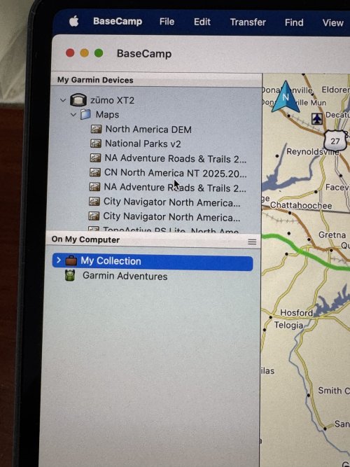
FWIW the Zumo XT2 does connect to Basecamp. At least it does on a Mac. I found that in the past with sketchy cell service the GPS is the most reliable source of electronic navigation. Paper maps are of course even better...YMMV


IMG_0924.jpeg
 
My limited experience has indicated that no one device is perfect. It depends on what areas you want to concentrate on and which areas you can live without. For me, the benefit of my Garmin Zumo XT is the other information provided on the screen. That is speed limit, changes in speed limit approaching, approaching a known deer crossing area, red light camera ahead, etc., These items are not presented on the map for the Connected Ride App (except speed limit), Apple maps, Google maps. The contrast of the maps on the Connected Ride App was less than ideal for me. Granted, selecting a point and getting directions on Google or Apple maps is very easy, but for me they are best utilized on my desktop and not while riding. The interface for selecting a point on the Garmin is not as user friendly, but for me it's worth it for the other information it provides. Plus, I really don't want to my phone via a RAM mount on the bike. That's a personal preference.
 
Last edited:
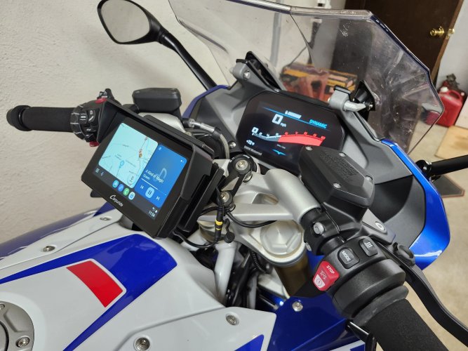
I use a Carpuride W502B on my RS. Google Maps can download maps for when out of cell coverage ( { am almost never out of coverage where I live). They have new units (BS designation) that use the whiz-wheel. My phone is safely in my pocket vibration free. Sena Mesh in the helmet. This is in split screen view, music and WAZE navigation.

20240618_115459.jpg
 
I use a Carpuride W502B on my RS. Google Maps can download maps for when out of cell coverage ( { am almost never out of coverage where I live). They have new units (BS designation) that use the whiz-wheel. My phone is safely in my pocket vibration free. Sena Mesh in the helmet. This is in split screen view, music and WAZE navigation.

View attachment 99894
That's fantastic. Have you had a reliable Bluetooth connection from it? That was an issue for some friends with earlier versions.

Nice tidy installation, eh? *chef's kiss*
 
I thought I had read on other posts that the XT2 does not use basecamp. My XT does. So, I would double check this if using basecamp is important to you.
That is correct. You can copy Basecamp generated routes via USB to the XT2 folder, but the XT2 must import, convert and recalculate the routes. Alternatively, you can import the Basecamp routes like any other 3rd party rogenerated routes via Tread, where once again, they are converted and recalculated. There is no way of just using a Basecamp generated route as is with the XT2. Basecamp and the XT2 does not share the same maps or routing algorithms, so you likely will have to mess around with shaping points to get the desired routing. Basecamp supports a number of advanced features such as departure times, that the XT2 does not currently support, which also get stripped off during the import.
 
That's fantastic. Have you had a reliable Bluetooth connection from it? That was an issue for some friends with earlier versions.

Nice tidy installation, eh? *chef's kiss*
I have always had a reliable connection with my Samsung S23 FE. Less than 10 minutes to get it installed and connected. I've put around 5,000 miles on my RS since install.
 
I have had no issues routing a trip in Basecamp and importing it on my XT2. I always have the GPS recalculate the route and then I check for any issues.
Where most people get into trouble with Basecamp is not zooming in enough to mark a waypoint.
That can lead to routing issues regardless of GPS used. YMMV
 
Environment and Requirements drive the solution...

For me:
1. I need a satnav that will reliably, faithfully and WITHOUT RECALCULATION follow the complex, tertiary road routes that I plot on my laptop while sipping my beverage of choice. I almost never do point to point, fastest route, navigation.
2. I don't need the satnav to do anything else, e.g., play music, monitor tire pressure, make calls, etc.
3. I need this capability throughout the US and Europe. And I don't want to pay for map updates.
4. I won't use Basecamp because, like pounding your head on concrete, it feels really good when you stop.
5. I want my route planning process to be simple, "google maps-like" drag and drop, without the limitations. And I want it to become a database of POIs that interest me.
6. I will not bolt my primary safety device, my phone, to the bike because if something really does go sideways, the likelihood I can reach it and it is working seems small.

After having numerous Garmin devices, I finally gave up on them in 2019 when I shipped a bike to Germany and Garmin wanted $99 for the Europe map on my "lifetime maps" device...the lifetime maps are only for the market where the device was purchased.

That led me to TomTom and their Rider 550 device and I could not be happier. Their route planner, which used to be called MyDrive, but now just TomTom Planner, https://plan.tomtom.com/en is incredibly easy to use, and syncs wirelessly with the Rider 550. I can keep a record of my POIs and routes, and it will show hotels (usually with clickable links), restaurants and even mountain passes. It will also import and export GPX files, so it makes it easy to share. And, BTW, TomTom is huge in Europe, almost as ubiquitous on bikes there as Garmin is here.

One of the best features when the route is displayed on the satnav is what they call the "route bar" which is a segment on the right that shows about a rolling 30 mile window of what's coming up, like gas stations, construction, delays, etc. Really helpful in planning gas stops in unknown territory.

Although the Rider 550 is seemingly discontinued in the US market, they are still available in Europe.

TomTom, like many other nav companies, has moved to a phone app, theirs is called TomTom Go. https://www.tomtom.com/en_us/navigation/mobile-apps/go-navigation-app/

I use this for car-based road trips because I can still plan my complex route in the TomTom Planner, it will sync on my phone using the GO app AND then I can use Android Auto to get it on my car's screen with the voice prompts over the audio system. The GO app also shows that really helpful route bar.

Which brings me to what I'd do today if I was building a new nav "solution" for my bikes: I'd use the TomTom Planner, the GO app and probably the Chigee device to get what I want. When and if my Rider 550s die, I'll likely go this route.

That said, I've read that mirroring your phone to the Chigee or similar device can really drain the battery and can overheat the phone. I haven't seen that problem when doing it in the car using AA and the GO app, but obviously that's a climate controlled environment.
 
Back
Top