•  

    Welcome! You are currently logged out of the forum. Some forum content will be hidden from you if you remain logged out. If you want to view all content, please LOG IN!

    If you are not an MOA member, why not take the time to join the club, so you can enjoy posting on the forum, the BMW Owners News magazine, and all of the benefits of membership? If you click here, you have the opportunity to take us for a test ride at our expense. Enter the code 'FORUM25' in the activation code box to try the first year of the MOA on us!


Last Day - Ridgecrest to Long Beach CA

Mark H

New member
Hi,

I'm hoping for a little local knowledge to help with a more interesting run from Ridgecrest to Long Beach CA for our final day on the road in the US.

This will be day 35 and I'm struggling to find an interesting or even mildly interesting route from Ridgecrest down to Big Pines and the eastern end of the Angeles Crest Highway.
This is the route we have so far, but Hwy 395 is looking a little straight for my liking - LINK to Google Map

We will have come from the west on the previous day via Sherman Pass. On the map it looks like there are very few options south of Ridgecrest other than possibly a detour via Edwards Airforce Base, but I wasn't certain we could get close enough to see anything in the way of jets etc. without getting arrested by the military police. I can't even find an interesting pit stop location for a coffee break other than possibly Randsburg.

If there is nothing on offer, we are happy to just do the straight run south and then enjoy Angeles Crest and lunch at Newcomb's Ranch before hitting the freeways into LA and Long Beach.
What do you SoCal people recommend? Is there a hidden gem on this desert stretch? :scratch
 
Sherman Pass?
Have you switched to a snowmobile?
Randsburg is the only stop thats "different" enough along your route to go a bit out of the way for.
I stop there, or just drive/ride thru every time I take 395. (I don't think anything is open before 10AM)
The map doesn't lie, the roads are straight as an arrow through that area until you get to the mountains.
The Trona Pinnacles are to the East of your route, and Wagon Wheel ORV area is South of that on Trona Rd.
I've never been close enough to see anything at Edwards or China Lake.
Your post did not include the date you will be transiting the area.
If it is late April, Willow Springs Raceway off the 14 has a vintage motorcycle race/swap meet weekend.
Bill
 
Last edited:
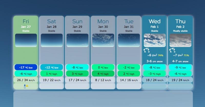
tanker4me is exactly right. You will need to touch base with the United States Forest Service (it's their road) before attempting Sherman Pass. Last week I saw a lot of weather pictures that showed it completeley snowed-in. This morning's weather report for the pass (just now) was this:

Screen Shot 2017-01-27 at 7.23.56 AM.jpg

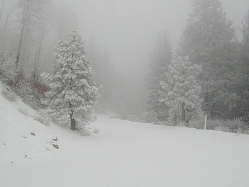
The picture below was taken in November 2016. As you've read (or experienced!), precipitation in CA in Dec and Jan has been epic. Sherman Pass will still be like this now:

shermansnows.jpg:

Assuming you'll be up in Kernville (there's a USFS office there), you'll end up coming east on 178 over Walker Pass instead. Walker Pass, further south and lower than Sherman Pass, is more likely to be clear of snow. Even if there's no snow, the roadway will be sandy. And clear or not, even it will be cold.
 
Last edited:
Crossing the desert can be boring sometimes, but it's new for you, so no biggie, right?
With the recent precipitation and cold that we've had, beware of ice - including "black ice", the hard-to-see kind - on the upper stretches of Angeles Crest, especially the fun twisty parts between Wrightwood and Saddle Peak.
 
Thanks for the replies, and thank you for the tips on the weather.

I certainly should have mentioned that we will be there in late June. It probably sounded slightly naive to be talking about Sherman Pass in late January, when parts of California (and large sections of the US) are experiencing such heavy winter snow falls.

Walker Pass is our Plan B if the weather is not great (rain possibly more than snow I guess in June), but I have read good things about the ride over Sherman Pass and the run down onto the eastern side of the mountains. On our first motorcycle trip to the US in 2014, we rode a section between Bakersfield, via Isabella Lake and Kernville, on our way to Three Rivers and Sequoia National Park.

Pauls1150 is right, we are not adverse to the desert experience, indeed every mile we ride in the US and Canada is treasured. We feel honoured to have the opportunity to share, even if for only a few weeks every now and then, the beauty and majesty of your backyards. The roads, the riding, and the welcoming smiles, create an environment that is nothing short of intoxicating.
So on the last day of this trip, we do indeed plan to soak up the calm expanse of the desert as we cruise down 395 before reaching Angeles Crest Highway. As we do, we will no doubt chat to each other about all the memories woven into the miles travelled.
 
You won't get anywhere near EAFB to see anything, even if you were riding offroad. If you did you'd be snagged.
So that's out.

Your best bet is what you planned. Hit Big Pines and do the Crest. On the way down you could cut down Upper Tujunga '9 mile' to Angeles Forest for a few more turns looping back to the Crest. Some of the better roads in ths area, and freshly re-paved just last year.

s a note, if you're interested in aircraft, when you come across the Antrlope Valley you can cut up Avenue S to around 30th East where there's an aircraft park with all the important planes. Shuttle carrying 747, SR-71, B-52, etc, all on display for free.
 
if you're interested in aircraft, when you come across the Antrlope Valley you can cut up Avenue S to around 30th East where there's an aircraft park with all the important planes. Shuttle carrying 747, SR-71, B-52, etc, all on display for free.

Thanks for the tip - it's always great to see these things up close.
 
Back
Top