• Welcome, Guest! We hope you enjoy the excellent technical knowledge, event information and discussions that the BMW MOA forum provides. Some forum content will be hidden from you if you remain logged out. If you want to view all content, please click the 'Log in' button above and enter your BMW MOA username and password.

    If you are not an MOA member, why not take the time to join the club, so you can enjoy posting on the forum, the BMW Owners News magazine, and all of the discounts and benefits the BMW MOA offers?

  • Beginning April 1st, and running through April 30th, there is a new 2024 BMW MOA Election discussion area within The Club section of the forum. Within this forum area is also a sticky post that provides the ground rules for participating in the Election forum area. Also, the candidates statements are provided. Please read before joining the conversation, because the rules are very specific to maintain civility.

    The Election forum is here: Election Forum

Manual GPS complete with overview and constant zoom. 2021 edition

Omega Man

Fortis Fortuna Adiuvat
Staff member
Available on Amazon and places like Staples, The latest Manual GPS is now available!

e1c8fe7a-e002-4950-a153-1c9c5c74c13d.__CR0,11,300,300_PT0_SX300_V1___.jpg


Always charged, basically theft-proof (people have forgot the real value) with easily copied pages for mark-up.

Start dreaming of you next adventure
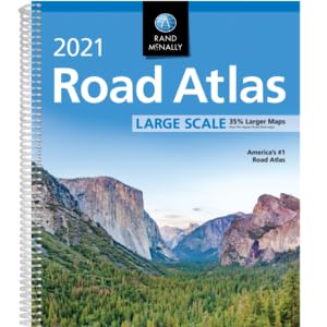
Rand McNally Road Atlases

For generations, Rand McNally has been compiling accurate, detailed maps and travel information into the ultimate road trip accessory.

The 2021 editions feature fully updated maps, mileage charts, road construction and tourism information, city detail maps, and more.

It's no wonder savvy travelers take the wheel with our Road Atlas by their side.

ISBN-10: 052802244X


Thumbwheel and bluetooth not needed.

Enjoy knowing where you are.

Oh yeah, only $18.00 bucks on Amazon.

OM
 
I highly recommend these, there's usually one not too far from me at all times. I've had several over the years and have never had to recharge batteries, replace a charging cable, or find a lost mount. Waze or a different GPS app are nice for zeroing in on local addresses, but nothing like the old tried and true method of trip planning.
 
I highly recommend these, there's usually one not too far from me at all times. I've had several over the years and have never had to recharge batteries, replace a charging cable, or find a lost mount. Waze or a different GPS app are nice for zeroing in on local addresses, but nothing like the old tried and true method of trip planning.

I always have two Atlases. One un-molested and one with map pages torn out of the atlas. These map pages go in the tank bag map pocket when in that locale.

But this is not mutually exclusive of a dedicated GPS. I always have one, and often use two GPS units mounted on my bike. The map is used for trip planning and the GPS is used to monitor the progress of that plan.
 
Last edited:
Not waterproof.
Difficult to operate with motorcycle gloves.
Screens tend to flip uncontrollably at common road speeds.
No mount, unit is known to disappear entirely at highway speeds.
Very low volume for voice directions.
Can't zoom in for more detail.
Shows only major roads, only a few county, residential or unpaved roads.
Unresponsive to requests for gas stations, restaurants and motels.
No updates.
Road construction info usually outdated before purchased, not real time.
Incapable of determining current position.
 
An excellent GPS option! At only $18 a pop it makes sense to use the new one for trip planning and tear pages out of the old for on-the-road reference.

I don’t know if the still make it, but H-D used to sell a branded atlas that was really handy for roadwork. It was easy to read and fit well in tankbag or saddlebag, and had all the dealer locations marked.

For mixed-use on & off road the Benchmark Maps are quite useful too, especially when seeking out campsites and recreation areas.

But, I still use my electronic GPS as well. And I still get lost—sometimes, that’s half the fun! :)

Best,
DeVern
 
Not waterproof.
Difficult to operate with motorcycle gloves.
Screens tend to flip uncontrollably at common road speeds.
No mount, unit is known to disappear entirely at highway speeds.
Very low volume for voice directions.
Can't zoom in for more detail.
Shows only major roads, only a few county, residential or unpaved roads.
Unresponsive to requests for gas stations, restaurants and motels.
No updates.
Road construction info usually outdated before purchased, not real time.
Incapable of determining current position.

I think you forgot works without a battery 🔋 How can anything work without a power source? :p

OM
 
If you have State Farm insurance you can pick up one free from your local agent.

I think they're around $10 at Walmart.
 
I’m kinda partial to Butler maps myself... though I only own one, the Appalachian special, north Alabama, eastern TN, NC, and GA. The yellow and orange highlights (G1&G2 roads) are worth the cost. Plus they are foldable, reusable, easy to read, tear resistant, and waterproof. The material, and marginal information reminds me of the blood chit I used in the Army.
 
Last edited:
I’m kinda partial to Butler maps myself... though I only own one, the Appalachian special, north Alabama, eastern TN, NC, and GA. The yellow and orange highlights (G1&G2 roads) are worth the cost. Plus they are foldable, reusable, easy to read, tear resistant, and waterproof. .

I have several I use for planning from the motel room. I'm too cheap to put those nice maps in my tank bag window :)
Last year I decided to update my Texas and Colorado Butler maps and was surprised I was able to sell the old ones for half price.
I like paper maps for dreaming.
The best Christmas present Debbie gave me was a Rand McNally box collection of all 50 US state maps. This was before we had internet so those maps got a lot of use for planning.
 
The best Christmas present Debbie gave me was a Rand McNally box collection of all 50 US state maps. This was before we had internet so those maps got a lot of use for planning.

We used to be AAA members. I never needed the roadside services but loved the free maps. When we went with a different roadside assistance plan I hated to give up the free maps but Voni gave me permission to buy any maps I needed anytime, no questions asked. ;)Fair deal!
 
We used to be AAA members. I never needed the roadside services but loved the free maps. When we went with a different roadside assistance plan I hated to give up the free maps but Voni gave me permission to buy any maps I needed anytime, no questions asked. ;)Fair deal!

My sister used to get me AAA maps for trips and that was great.
I noticed the last time I was in Barnes and Noble there map selection was pretty skimpy.
At least some states will still send out free maps with tourist info.

My map drawer.
Maps (3).jpg
 
I remember when gas stations gave out maps for free. Trying to use them in a car before air conditioning was something else.

I used to carry an atlas with me, but gave up. Now I use Google Maps to rough out my route, polish it in Base Camp, and upload it to my Nav V.
 
I always have a paper back up on either my motorcycle or on my boat... It is the prudent rider/skipper that is prepared. Better to have and not need, than need and not have..
That goes for a lot of things BTW... YMMV..
 
It is also a great device for noting roads that you have travelled. I mark those roads with an orange highlighter and when planning a trip choose the "roads not ridden".
 
Several states seem to be getting away from printed maps... not sure if cost cutting/ budget or tech driven. Two states on a recent Appalachian swing had nothing availabile. Maybe WVA and VA? I was told to just use online offering at one and another found a 2018 version in “ the back“. I had older worn out versions so not dead in the water. The paper used isn’t as durable as maps “ back in the day” either.
I had sent requests to several states using their online tools for maps and got a lot of travel guides with sad maps on a page in the tourist guide.
One park staffer told me to just use my phone even after I explained why I used a paper map and a highlighter :banghead
I do carry two like Paul does as well and one has had pages pulled out for tank bag.
Love my GPS(s) but maps let me see a lot more at a glance and what to punch into Ms Garmin on the fly.
One other issue is the coated maps as mentioned you can’t or do not want to mark up as well as they have gotten larger so you have to fold and flip way more often in states East of the Big Muddy.
 
Most roadside rest areas have free maps. That doesn't much help for trip planning!

That works sometimes if you travel on interstates.
Arkansas does a good job of having welcome centers with maps on 2 lane roads.
A motel we stayed at in Arkansas this year had a big stack of state maps in the lobby.
 
That works sometimes if you travel on interstates.
Arkansas does a good job of having welcome centers with maps on 2 lane roads.
A motel we stayed at in Arkansas this year had a big stack of state maps in the lobby.

States that consider tourism to be a major part of their economy seem to do a pretty good job with travel materials: maps, good guide books, good campground information, etc.

States that have a minimal tourism sector, or don't care about tourism anyway do a much poorer job.

Which thought again compels me to tell a story. About 20 years ago the State of Kansas Tourism Department did a survey at all of the rest areas where motorists enter the state on Interstate highways. The survey had some "open ended" questions, one of which asked what was their favorite destination in Kansas. Dodge City came in Number 2. The most frequent answer was, "the Colorado state line." This particular result was not widely revealed but as a city community and economic development guy I got to see the real results which I foud hilarious.
 
Back
Top