• Welcome, Guest! We hope you enjoy the excellent technical knowledge, event information and discussions that the BMW MOA forum provides. Some forum content will be hidden from you if you remain logged out. If you want to view all content, please click the 'Log in' button above and enter your BMW MOA username and password.

    If you are not an MOA member, why not take the time to join the club, so you can enjoy posting on the forum, the BMW Owners News magazine, and all of the discounts and benefits the BMW MOA offers?

  • Beginning April 1st, and running through April 30th, there is a new 2024 BMW MOA Election discussion area within The Club section of the forum. Within this forum area is also a sticky post that provides the ground rules for participating in the Election forum area. Also, the candidates statements are provided. Please read before joining the conversation, because the rules are very specific to maintain civility.

    The Election forum is here: Election Forum

Big Sur and Pfeiffer Canyon Bridge CLOSED

Mark H

New member
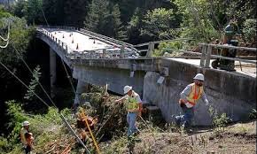
Hi - just heard that the Pfeiffer Canyon Bridge south of Big Sur has failed due to a land slide and is being demolished.

We were planning on a ride from Paso Robles up Highway 1 to Monterey as part of a bigger ride for the day to take in the spectacle that is the famous coast road, but now we may need to go inland and we are gutted.
Just to make things even more complicated, there seem to be some additional rock slides on the southern end of Hwy 1 towards Ragged Point and San Simeon, but I'm hoping these will be cleared within days or weeks.

I want to avoid Hwy 101 at all costs as this is not the type of road we like to ride.
So I was looking on Google Maps and could see this route - LINK

Or possibly go as far up the coast as possible (a few miles north of Plaskett) and then take Monterey Co Route 4004 east to Nacimiento Fergusson Rd and on to Jolon before swinging north on Jolon Rd and doing the last part of the route from the link above.

We are not in the US until late May, but that bridge is not getting rebuilt any time soon.
Do any of you local Californians know of a way through this area? We are not averse to some hard packed forrest roads but would like to avoid cross country goat tracks.

Any help would be greatly appreciated.
 
Last edited:
Hi Mark,

The Pfeiffer Creek Bridge

images.jpg

is being demolished now, and it'll be a year, more or less, before a replacement is finished.

The slides now blocking the southern end of Highway 1 will likely be cleared within a week or two.

If the slides are indeed cleared (and you can get current information by entering the route number on this page) and CalTrans reopens the southern end of the road, you will be able to ride north on Highway 1 from Morro Bay and Cambria as far as Pfeiffer Creek, but no further. A good route would be north on 1 as far as Nacimiento-Fergusson Road, then east on Nacimiento-Fergusson to Jolon, north on 101 and pick up Carmel Valley Road as shown on your map. N-F's ascent of the Coastal Range will be among the most dramatic parts of your trip.

The first part of the alternate route shown on your map (via Nacimiento Lake Drive and Interlake Drive) is small, so-so paved surfaces through usually-dry but very lovely coastal hills. It's quite different from being on 1. For my money, 1 is more dramatic, and if it's open south of the N-F Road intersection, I'd take the coast. You choose.

The rest of your route is fine, 'tho you'll find that much of 1 (from Carmel north) and 156 (from Castroville north), and 101 (from Gilroy north) is unattractive big freeways surrounded by cities. The road over Mt. Hamilton is very pretty; the climb is extremely slow and tight, the descent a bit better.
 
Last edited:
Hi Mark,

The Pfeiffer Creek Bridge

View attachment 60728

is being demolished now, and it'll be a year, more or less, before a replacement is finished.

The slides now blocking the southern end of Highway 1 will likely be cleared within a week or two.

If the slides are indeed cleared (and you can get current information by entering the route number on this page) and CalTrans reopens the southern end of the road, you will be able to ride north on Highway 1 from Morro Bay and Cambria as far as Pfeiffer Creek, but no further. A good route would then be north on 1 as far as Nacimiento-Fergusson Road, then east on Nacimiento-Fergusson to Jolon, north on 101 and pick up Carmel Valley Road as shown on your map. N-F's ascent of the Coastal Range will be among the most dramatic parts of your trip.

The first part of the alternate route shown on your map (via Nacimiento Lake Drive and Interlake Drive) is small, so-so paved surfaces through usually-dry but very lovely coastal hills. It's quite different from being on 1. For my money, 1 is more dramatic, and if it's open south of the N-F Road intersection, I'd take the coast. You choose.

The rest of your route is fine, 'tho you'll find that much of 1 (from Carmel north) and 156 (from Castroville north), and 101 (from Gilroy north) is unattractive big freeways surrounded by cities. The road over Mt. Hamilton is very pretty; the climb is extremely slow and tight, the descent a bit better.

^^^^+1
That's how I would do it. When I do a 3-6 hour ride, those are 3 of my 5 favorite local rides. That route would have to be one long day?

John
 
Mark,

John's right - the route shown on the Google Maps link would be a very long ride, more than I'd choose for a single day. (OTOH, I'll be 70 in June, and that might affect my perspective. <g>)

Assuming you can get up 1 to N-F Road, then east into the Salinas Valley, another road to consider is east from San Lucas on 198 to the Highway 25 intersection, then north on 25 to Hollister. This portion of 25 is seriously rural and lovely and the pavement and curves are great. You could stay in Hollister, then take 25 north to 101, scoot up to San Jose, and go over Mt. Hamilton. If you did that, you'd give up Carmel Valley Road (lovely coastal hills and valleys but poor pavement) and the coast/inlands from Carmel and back to 101 (meh). But you'd get Highway 25, among the best-ever bike roads. It'd be a good trade, and you'd break up an awfully long day into two.
 
Last edited:
Thank you for the feedback and for the suggestions.

My wife and I have been discussing it and we are getting over the fact that we won't get to ride Big Sur, but we had the pleasure of riding the full length of the coast road back in 2014 from North to South and nothing will ever match that. So, the idea of riding inland and experiencing new roads is sitting well with us now.

Unfortunately, we are committed to getting from Paso Robles to Merced in the day and it will be a big ride.

The option of the coast to N F Road and then east looks amazing. Then part of 198 and 25 to get off 101 before heading up through the Carmel Valley looks great too.
One option that was also suggested was to go north out of Paso Robles, then north east on Vineyard Canyon Road to Parkfield, then north on Parkfield Coalinga Road which looks fantastic and twisty. Swing north west on 198 then 25 to Lonoak and then on Lonoak Rd west to get to the Carmel Valley stretch.

That's where we start to add lots of miles in a big sweep around to get to san Jose and the Mt Hamilton run.
I'm tempted to sacrifice the run through Carmel Valley and substitute the more direct route up 25 to Hollister as David suggested, in order to keep the total length of the ride through to Merced under control.

Having said that, it saves only 50 miles, but it does avoid the messy section north of Monterey. And if the road surface through Carmel Valley is not the greatest, it may be a sensible choice.
So it could look like this - LINK
 
Taking Vineyard up from San Miguel, through Parkfield, then up the Parkfield Grade to 198, and 198 to 25 to Hollister will take you into serious Old California: ranches, farms, not many people or much traffic, wooded and flowered hills. Other than the tech you're riding on, it will be easy to feel that you've gone back 50 or a hundred years.

I think you're wise to abandon the Carmel Valley Road, and the not-very-swell stretch of 1/156 from Carmel to 101. While N-F is fabulous, you've ridden the coast before and that'll have to do.

This is a significant improvement, IMO. It's still a serious long day, but it's more doable than what you'd earlier proposed.

Interestingly, Google Maps has just now put a block on the coast road above Ragged Point. The system will not let me create routes over that part of Highway 1.
 
Just finished mapping this out and we are now very pleased and excited with the new route.
Nothing will ever eclipse the experience of riding down HWY1 past Big Sur, but we will keep that in our memories and look forward to new adventures.

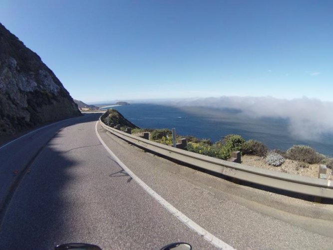
Just for the sake of it and for anyone who may be interested - a short section of our ride down the coast from 2014 - VIDEO LINK

PH003591.jpg
 
Back
Top