• Welcome, Guest! We hope you enjoy the excellent technical knowledge, event information and discussions that the BMW MOA forum provides. Some forum content will be hidden from you if you remain logged out. If you want to view all content, please click the 'Log in' button above and enter your BMW MOA username and password.

    If you are not an MOA member, why not take the time to join the club, so you can enjoy posting on the forum, the BMW Owners News magazine, and all of the discounts and benefits the BMW MOA offers?

  • Beginning April 1st, and running through April 30th, there is a new 2024 BMW MOA Election discussion area within The Club section of the forum. Within this forum area is also a sticky post that provides the ground rules for participating in the Election forum area. Also, the candidates statements are provided. Please read before joining the conversation, because the rules are very specific to maintain civility.

    The Election forum is here: Election Forum

Would love some Oregon Washington road suggestions

I just returned from a weekend in Enterprise.

We camped at the Log House Campground www.loghouservpark.com. The hosts, Brian and Margaret are both riders and extremely hospitable. This would make a great layover point for anyone riding to the National through Lewiston. There is a ton of DS riding around Enterprise. As someone said around the campfire, "You can't make a wrong turn".

Regarding Wallowa Mtn. Loop (nfs39). It is closed this season. I heard that there is a bypass, Hess Rd.. I don't think Hess is paved. All three times I've been there to ride it, it has been closed.

So if you're in Enterprise-Joseph, any idea what the trick is for getting to Hell's Canyon on paved roads? I may have to rethink my route plan through that area since Nf 39 looked like the most direct route. Thanks for the heads up.
 
Cape Meares

When you pass through Tillamook, it is Cape Meares not Searles. Great loop out to the lighthouse viewpoint and south along the coast a bit then back into Tillamook and STRAIGHT east through town on OR hwy 6 and up the Wilson River canyon . AWESOME sweepers up a gnarly woodsy canyon to the highway 26 that connects Portland OR to the coast. Before you get to 26 though you should watch for the cutoff to TIMBER and take it north to cross 26 and continue to Vernonia, then 202 to 47 and MIST and north to Clatskanie on the Columbia River. By then you will be wore out from the twisties. Head west on 30 to WESTPORT where you hop a small ferry across the river to Skomokawa and take 4 west to NAselle and take the road south to the Astoria bridge via megler and follow 101 north along Willipa bay. Awesome twisties there. Its all good.
-Sirby:brad
 
So if you're in Enterprise-Joseph, any idea what the trick is for getting to Hell's Canyon on paved roads? I may have to rethink my route plan through that area since Nf 39 looked like the most direct route. Thanks for the heads up.

May I suggest that you rethink your riding tactics rather than the route? In wild, scenic areas such as Eagle Cap Wilderness, some roads will be paved; others will be under construction, damaged, or bypassed by detours. If you want to experience such areas, you should assume that even in the best of conditions you will encounter some dirt and gravel.

An RT will do gravel with a bit of skill. If gravel makes you nervous, may I suggest you learn to ride it rather than try to avoid it? And, since the primary difference between street and dual sport is the tires, you might think about changing tires to something like Bridgestone TW42. If you just take it easy and favor the footpegs, an RT will handle reasonable gravel roads without much drama.

The best way to determine the condition of roads in remote areas is to contact the responsible agency directly by telephone, close to the time you intend to be there. Then you can make a go-no go decision. The number I have for the Eagle Cap Wilderness Area is 503 426-4978. The ranger station is at Enterprise.

The only way to get south from Joseph with minimal risk of an unpaved road is to retrace your steps to LaGrande, and take the superslab south to Baker, then east. For a quieter (paved) alternative, ride 203 via Union and Medical Springs. Note the Oregon Trail Interpretive Center just east of Baker City on 86

pmdave
 
Sirby,

I noted your suggested route out of Tillamook and will try and cover it for sure. That's certainly something I wouldn't have plotted on my own so once again thanks for the great suggestion. One of the issues I'm encountering is trying to cover all the suggested routes for this trip and pack them all into one 15 day trip. I'm still making adjustments.

Dave,
Thanks for the phone number on road conditions which I'll keep with me. A dirt road with gravel is fine. I just didn't want to kill a half day just to make it through an area that's ends up super slow going and takes away from seeing other areas of the trip. if the scenery and area is a "Must see", I'm there. On a long vacation it definitely wouldn't be a factor. If the RT can make it through there so can I. That route 203 at La Grande looks like a good alternative both to Riding 84 or if the need arises to cutting out NF39 out of Joseph.
 
Last edited:
Ride overview

Well I hope to have the clutch out on Thursday morning between 6:30 and 7am to beat the Texas heat and the Dallas rush hour traffic. It's also looking like my dear riding companion "Doc" Hermann will be joining me this trip so I'm extra pleased. We both have the exact same bike with the only difference is his is blue and the other great thing is we have bike to bike radios. Only way to go in my opinion.

Here's the general route so far. The first four days are long ones and then we slow it down to ride as we feel.

Day 1 Dallas to north of Albuquerque

Day 2 Albuquerque taking 550 up to Farmington ( Haven't ridden that stretch before) and then west on 64 into Utah. We're either going to pick up 191 up to Blanding and then 95 to Hanksville or there is a highway 163 going near Mexican Hat and then 261 onto 95. Would love a comment from anyone who's ridden those. We're spending the night in Torrey.

Day 3 Torrey to Ely, Nevada and then pick up 6 to Tonopah for the night.

Day 4 Tonopah over to Highway 395 in California and riding it north before cutting over to west side of Lake Tahoe and spend the night in Truckee.

From here it's whatever unfolds each day, but below is the general route:

Truckee on 89 up near Prattville and then take 36 through Red Bluff stopping for that hamburger in Platina and over near Ferndale. We have the loop Ian (Visan) suggested taking in Patrolia, Mattole, and Ferndale and then through Eureka. Hope to stop at Samoa Cook House for a meal in Eureka.


From Eureka north along the coast to Cresent City and then 199 through Grants Pass on to Crater Lake.:thumb

From Crater Lake heading west (138 and 38) to the coast near Reedsport and riding the coast through Florence and so far up to Newport. From Newport east to Detroit and north on 224 to Troutdale and ride that Historic Columbia River route to see the Multnomah Falls.

From there head north on NF 25 and hopefully get to ride the road that cuts west into Mt ST Helens. Mt St Helens north to Rande. At Rande going west to Hwy 7 north and make the run through Mt Rainier.

From Mt Rainier taking 12 to Yakima and then south on 97 to ride the river and then Paterson to Prosser. Prosser through Walla Walla and down to Enterprise. Enterprise to Hells Canyon - dirt or no dirt!

This leaves out Coulee Dam and the recent suggested Tillamook to Astoria by Wilson River Canyon. From Hells Canyon it's on to home.

That's the tentative plan and we're open to make last minute tweaks.

Thanks to all who made the many great suggestions. Gotta love this forum !!! Hope I can sleep Wednesday night.
 
That is really too bad; it's one of the best roads I have ever been on.

Wow Rinty, That says a lot knowing your neck of the woods. This same situation happened some years back with the Beartooth Pass and I had to make other arrangements that year. I've since managed to ride the Beartooth several times and it sure appears they fixed it for the better. Hopefully the same thing will happen on nf-39 and it will improve for the best.

Gotta love this forum. Thanks to you this just saved me a ton of time. I only hope other riders planning routes through there to and from the rally will get this info.
 

Well, that sector is exotic, and remote. It has a different kind of beauty than our Rockies, or the Kootenays.

I like the area so much that, after the last Redmond National, I returned a few months later with my wife. We were driving her roadster at night, across the Umatilla Plateau on the lovely winding 395, and you could smell the pines. When the temperature dropped to 5 C, I suggested that we stop and put the top up. She said to leave it, and just turn the heater on. :thumb

Highway 39f is good asphalt, about a lane and a half wide, and the biggest challenge is swerving around the many Chipmunks that run across the road.
 
"We're either going to pick up 191 up to Blanding and then 95 to Hanksville or there is a highway 163 going near Mexican Hat and then 261 onto 95. Would love a comment from anyone who's ridden those. We're spending the night in Torrey."


Either way is a nice run. Make sure you gas up before heading towards Hanksville, not much at all out there but beautiful scenery.

If you decide to go via 163 to 261. You will have to go up Moki Dugway. 2.2 miles of very good dirt road up a side of a cliff. 10% grades and switchbacks. Views are outstanding, but I would stop to take them in instead of driving and looking.. it is a long way DOWN :)

If time is available, I might suggest taking a detour at Torrey and head south on Utah 12. Awesome run through Grand Staircase-Escalante. You will end up at Panguitch and head north to Utah 20 via US89. Over to I15, then north to Beaver and pick up Utah 27 and out to US 6 at Baker, back on your original route toward Ely.

This suggested route is 297 miles approx vs Torrey to US 50 near Aurora - Scipio - Delta - Baker NV  230 miles. 60 miles further.

No matter which way you head, plan for GAS, not much is available as far as gas stations in this area. Myself I tend to find them about every 100 to 150 miles, of course there may be some closer, but plan accordingly.
 
I was wondering what that stretch of road on the map was that looked like a bowl of spaghetti. Moki Dugway. Who would have thunk it. If the weather is dry and clear I think it would be fun to take that route and get some photos. I assume the rest of the run is paved. If coming from the south are you climbing or descending or both?

I've ridden Hwy 95 from Blanding to Hanksville. Very spiritual road for sure and I've been on 12 to tour the parks, Bryce, Zion and north side of the Grand Canyon. Also had a good breakfast at a place on the Burr Trail in Boulder and rode much of the Burr Trail.

I've spent the night in Beaver before heading to Ely and Reno so familiar with some of those areas.

You're definitely right about the gas in those parts. Rule #1- If you see gas, buy it.

Thanks for the great tip.
 
"We're either going to pick up 191 up to Blanding and then 95 to Hanksville or there is a highway 163 going near Mexican Hat and then 261 onto 95. Would love a comment from anyone who's ridden those. We're spending the night in Torrey."
------------------------------


Either way is a nice run. Make sure you gas up before heading towards Hanksville, not much at all out there but beautiful scenery.

If you decide to go via 163 to 261…. You will have to go up Moki Dugway…. 2.2 miles of very good dirt road up a side of a cliff. 10% grades and switchbacks. Views are outstanding, but I would stop to take them in instead of driving and looking….. it is a long way DOWN :)

If time is available, I might suggest taking a detour at Torrey and head south on Utah 12. Awesome run through Grand Staircase-Escalante. You will end up at Panguitch and head north to Utah 20 via US89. Over to I15, then north to Beaver and pick up Utah 27 and out to US 6 at Baker, back on your original route toward Ely.

This suggested route is 297 miles approx vs Torrey to US 50 near Aurora - Scipio - Delta - Baker NV – 230 miles…. 60 miles further.

No matter which way you head, plan for GAS, not much is available as far as gas stations in this area. Myself I tend to find them about every 100 to 150 miles, of course there may be some closer, but plan accordingly.
 
Last edited:
Mexican hat is low, very steep climb via Moki Dugway in 3 miles to 8000. Nice run to 8500 where U meet 95 mostly straight but it is not at the same time. From 95 back to lake Powell... again great red rocks and canyons. FAST if pushed, hard not to do it slow :) Great run from Hanksville to Torrey, 45mph for the most part, but worth it.

Torrey south, great mountain run, to 9600', cool in the summer, back down to Boulder. Now be ready for the Grand Staircase. Not enough words to describe it. After Escalante, great road to Bryce and Panguitch via Red Canyon. Utah 20 is nice climb again, but short. Mostly from there out to Baker is so so of a run, nothing to really write home about.

All of these routes are good roads, but for Moki itself and that is good for a dirt road. Motorhome's take it all the time, but I wonder why, I would not.

If time is available, I would spent more in this part of Utah. back tracking, going over some parts again and again.

I myself like: great mountain or scenic drive in Utah, I normally hit a few per run.
UT 72 from Loa to I-70.
UT 25 around Fishlake to UT 72.
UT 22 from Bryce to Antimony and either 62 to Junction or up to Koosharem.
UT 31 from Huntington to Fairway.
UT 191 from Price to Duchesne
UT 191 from Vernal to Greenriver, WY
UT 35 from Duchesne to Francis
 
95 Between Blanding and Hanksville is drop-dead spectacular red rocks and wilderness. And of course Mexican Hat is right at the east end of Monument Valley. I don't remember any gas between Blanding and Hanksville.

I would suggest skipping Natural Bridges Nationial Monument unless you have too much extra time on your hands. To see the bridges requires hiking up and down. Instead, spend some time at the Hite overlook, a couple of miles after you cross the bridge.

Be aware that 261 north of Mexican Hat travels across the flats for a few miles and then SUDDENLY ascends up the face of a cliff, on gravel. Up on top, the pavement starts again.

I do suggest some sightseeing in the Capitol Reef area. The road into the park is paved for a number of miles, and you get some spectacular views of the reef itself.

Torry has facilities, including lodging, food, and fuel. If you are ready for the best southwestern food in the region, that would be Cafe Diablo, an obscure building on the south side of the highway at the west end of Torrey.

If you have an extra day, the loop from Torrey south on 12 to Boulder, Escalante, Tropic, etc. includes scenery from alpine forests to red rock canyons. Bryce Canyon is at the west end of 12. Here's a hot tip for visiting Bryce Canyon in a hurry: take the first viewpoint after the commercial strip, prior to the actual entrance. It's every bit as scenic as the other overlooks, and the hoodoos all look just about the same throughout the park.

89 north is through "cowboy" country, nice views and sweepers through canyons.

If you're heading west from here, I would suggest avoiding the Salt Lake City area insane traffic, and riding west on 50. Yes, it's lonely out there, and be sure to gas up and carry water.

pmdave
 
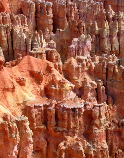
Just to give you some ideas, here's a shot of the hoodoos at Bryce Canyon. And this same scene goes on for miles, gaining altitude toward the south end.

pmdave
 

Attachments

  • Bryce hoodoos 01 sm.jpg
    Bryce hoodoos 01 sm.jpg
    151.7 KB · Views: 39
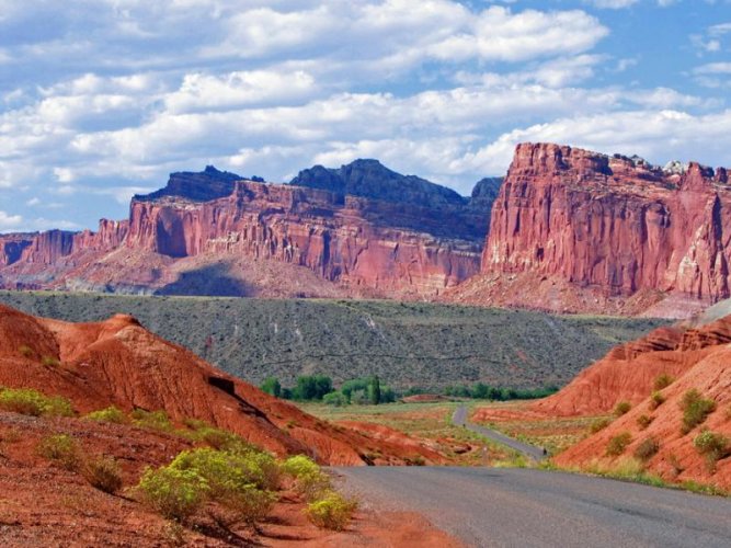
Or, maybe you're wondering what Capitol Reef looks like.

pmdave
 

Attachments

  • Cap Rf ed sm.jpg
    Cap Rf ed sm.jpg
    93.1 KB · Views: 39
I myself like: great mountain or scenic drive in Utah, I normally hit a few per run.
UT 72 from Loa to I-70.
UT 25 around Fishlake to UT 72.
UT 22 from Bryce to Antimony and either 62 to Junction or up to Koosharem.
UT 31 from Huntington to Fairway.
UT 191 from Price to Duchesne
UT 191 from Vernal to Greenriver, WY
UT 35 from Duchesne to Francis

Those are some good out of the way roads to note next time I get back to Utah. I've been on 191 Vernal to Flaming Gorge numerous times and will pass through Price on my way to Aspen. Thanks for your help.
 
I do suggest some sightseeing in the Capitol Reef area. The road into the park is paved for a number of miles, and you get some spectacular views of the reef itself.

Torry has facilities, including lodging, food, and fuel. If you are ready for the best southwestern food in the region, that would be Cafe Diablo, an obscure building on the south side of the highway at the west end of Torrey.

If you have an extra day, the loop from Torrey south on 12 to Boulder, Escalante, Tropic, etc. includes scenery from alpine forests to red rock canyons. Bryce Canyon is at the west end of 12. Here's a hot tip for visiting Bryce Canyon in a hurry: take the first viewpoint after the commercial strip, prior to the actual entrance. It's every bit as scenic as the other overlooks, and the hoodoos all look just about the same throughout the park.

89 north is through "cowboy" country, nice views and sweepers through canyons.

If you're heading west from here, I would suggest avoiding the Salt Lake City area insane traffic, and riding west on 50. Yes, it's lonely out there, and be sure to gas up and carry water.

pmdave

I'm spending the night in Torrey so hopefully I'll get there early enough to try Cafe Diablo. That looks awesome! It's now looking like my riding buddy is bowing out so I'll be solo this trip.

I've ridden 95 Blanding to Hanksville and don't recall gas until Hanksville. I think what I'll do when I get to 191 to head west on 163 to ride Moki Dugway, I'll stay on 191 going east a few miles and take on more fuel in the town of Bluff. I've marked a Sinclair gas station as a way point on my GPS. Better safe than sorry.

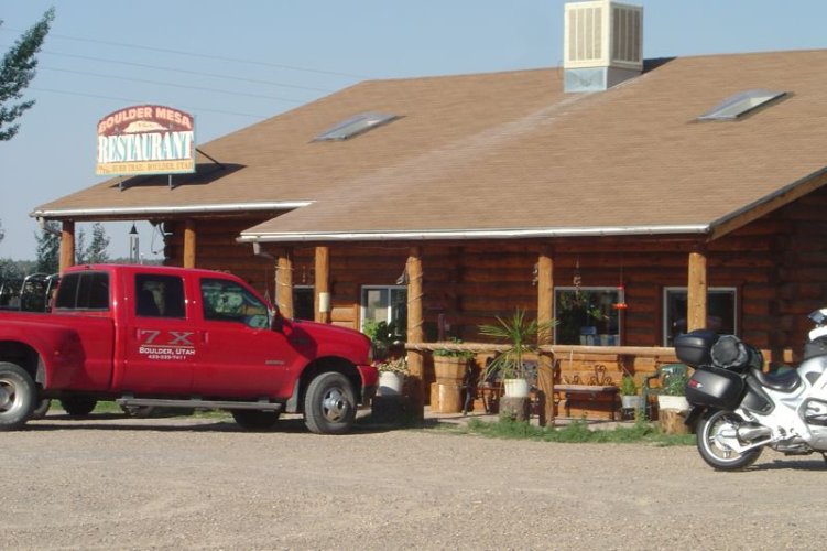
I've ridden 12 going south from Torrey and got an inside scoop from a local to turn off 12 to find the Boulder Mesa restaurant for good breakfast.

I fill my Camelbak with ice and water every morning in addition to along the way so I can stay hydrated. Ice cold water at all times. I also use a Polar Wrap around my neck. This has pellets inside that cause it to stay soaked with water for hours and the airflow over it makes it cool over my carotid arteries. To finish it all off I ride on Beadrider beads to keep me comfortable.

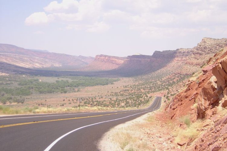
Here's a shot from 95. I think I saw two cars the whole way.
 

Attachments

  • 951.jpg
    951.jpg
    72.8 KB · Views: 69
Or, maybe you're wondering what Capitol Reef looks like.

pmdave

I'm seeing what blowing off the rally looks like.
With a week off in July why in Gods name would I go someplace to sit and talk about riding?
Yeah, I know there are day rides...
But seriously...

Rallys need to be held in Maine in January. :)
 
Don't know if this is still in Boulder, but it was a good breakfast stop Still had my 1150RT back then. Loved that bike.
 

Attachments

  • boulder mesa.jpg
    boulder mesa.jpg
    77.4 KB · Views: 69
Back
Top