• Welcome, Guest! We hope you enjoy the excellent technical knowledge, event information and discussions that the BMW MOA forum provides. Some forum content will be hidden from you if you remain logged out. If you want to view all content, please click the 'Log in' button above and enter your BMW MOA username and password.

    If you are not an MOA member, why not take the time to join the club, so you can enjoy posting on the forum, the BMW Owners News magazine, and all of the discounts and benefits the BMW MOA offers?

  • Beginning April 1st, and running through April 30th, there is a new 2024 BMW MOA Election discussion area within The Club section of the forum. Within this forum area is also a sticky post that provides the ground rules for participating in the Election forum area. Also, the candidates statements are provided. Please read before joining the conversation, because the rules are very specific to maintain civility.

    The Election forum is here: Election Forum

First Time Heading West - Could Use Some Advice

Advice regarding Chicago and booking hotels/camping

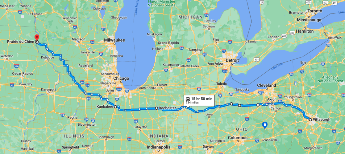
I'm coming from Pittsburgh. I really like your suggested route going up to Prarie du Chein and them west, but I'm trying to find a way around Chicago. I've only driven the freeways in Chicago in a car, and I definitely don't want to ride through there on my bike. Especially since I'll be getting tired around that time. Any good route you would suggest that takes me below Chicago but not too far south? Also, when you travel do you typically book a hotel/campsite prior to the day of travel or start looking when you get near your destination for the day? Thanks, Don

Take layers. Temps can be wildly variable at altitude. Know the signs of altitude sickness and if it effects you don't camp up high.

I'm not sure how much time you have or what part of PA you call home, but here are a few personal thoughts on cross-country transits. Avoid Chicago and surrounding areas. I follow the Kankakee River NW, then backroads to Prairie du Chien WI into the hilly, pretty part of Iowa. Pick up US-18 and follow it west; it's scenic and you can make good time while seeing small town America. Consider camping in the Niobrara/Pickstown area as you cross the Missouri River. Angle NW to SD-44 and pass through Badlands NP. From there to the Black Hills and explore all the area has to offer. I found the city park in Spearfish to have some of the best camping in the area. Devils Tower is a treat, but arrive early in the morning to beat the crowds.

Short stretch of slab to Gillette, then 14/16 to Buffalo and on into the Big Horn Range with many camping options. 16 to Ten Sleep, north to Graybull, 14 up Shell Canyon to Burgess Junction, then ALT14 to Cody. Much western history there. Over Chief Joseph Byway and Beartooth Pass. Back over Beartooth and through Yellowstone (early, unless you plan on spending a week there), drop down to Teton then further south to Flaming Gorge UT. South again to Colorado National Monument, over Grand Mesa to Montrose CO, west at Ridgeway to CO-145 south over the San Juans and dispersed camping options, 160 to Durango and up the incredible US-550 back to Montrose. US-50 east to Black Canyon of the Gunnison, then south on 149 over Slumgullion Pass with a stop in Creede CO. That will dump you out on US-160.

At that point I'd be concerned about conditions at altitude. If clear, you could travel up US-24/285 to Evergreen and take in Mt Evans and/or Guanella Pass with plenty of options for side trips to fantastic alpine lakes, streams, peaks, etc. Or if the weather looks threatening US-160 or US-590 will take you east in a hurry

Pete
 
I'm coming from Pittsburgh. I really like your suggested route going up to Prarie du Chein and them west, but I'm trying to find a way around Chicago. I've only driven the freeways in Chicago in a car, and I definitely don't want to ride through there on my bike. Especially since I'll be getting tired around that time. Any good route you would suggest that takes me below Chicago but not too far south? Also, when you travel do you typically book a hotel/campsite prior to the day of travel or start looking when you get near your destination for the day? Thanks, Don

Like you, I went through Chicago just once (with Barley in a sidecar rig). Though it was 6am on a Sunday and traffic was "light" by their standards, never again!

You can make good time on US-30, but that's too much like an Interstate for me. My preference is US-224 and 24 which are for the most part two lane highways with fewer big rigs and city craziness west of Akron. From Kankakee IL I follow the Kankakee River toward I-80, then string together a series of back roads up to Prairie du Chien. That route is far enough away from Chicago sprawl that you can relax and enjoy the scenery.

I tend to research hotels and campsites ahead of time so have a list of them with suitable reviews along my general route, but tend not to reserve more than a few hours ahead of time. That way I'm not a slave to mileage in adverse conditions, nor do I have to stop for the night on one of those perfect riding days when I feel like pressing on.

One word of caution based on my cross-country rides over the last two years. Don't assume that mom n pop hotels or diners are still open just because they appear on Google Maps. Many of them folded during the pandemic, especially those on back highways, unless they were linked to another source of revenue like a gas station. It pays to call ahead to make sure they're still in business.

Screen Shot 2022-08-27 at 7.13.40 AM.png
 
Do you get surprise heavy snows in Colorado/Wyoming area or can you always catch them by watching the forecast carefully and traveling away form them (hopefully they are better at forecasting than they are here). Being a novice in the mountains and hitting snow would truly freak me out.

I had at least a three day warning on my phone weather app. I use NOAA.
My GPS also shows weather and weather radar. I don't remember the name of the Garmin app. It was a one time $5 fee.
On the GPS I would get a warning every 30 minutes or so of the winter storm.
The NOAA forecast was accurate to a few hours when the storm would hit.

As for rain in the mountains, that can be difficult to predict.
 
I agree with Pete to not go north of Kankakee. One time we took two lanes a little south of the Chicago area and it was a mess because we were too close to the cities.
Besides Pete's route another option is take one of the ferries across Lake Michigan. We have not done this but it looks interesting.
One at Muskegon and one at Ludington.
Besides finding places that have closed the last two years we keep finding the Google hours for restaurants to not be helpful. Plenty of times Google will say they are open that day but when we walk up to the door there's a paper note saying they are closed today due to lack of workers.
 
The SS Badger from Ludington MI to Manitowoc WI is a great experience, the last Coal fired commercial vessel in the USA.

May 12th, 2022-October 16th, 2022
Depart - Ludington 9:00 AM (ET)
Arrive - Manitowoc 12:00 PM (CT)
Depart - Manitowoc 2:00 PM (CT)*
Arrive - Ludington 7:00 PM (ET)
Crossing time: 4 Hours
Ludington is Eastern Time (ET) | Manitowoc is Central Time (CT)

Call 800-841-4243 for information or to make a reservation.
 
I believe I was told there is another ferry crossing further south that crosses is less time if one is in a hurry.
 
I believe I was told there is another ferry crossing further south that crosses is less time if one is in a hurry.

Yep, one at Ludington and one at Muskegon.

Here's the Badger.
<iframe width="1184" height="666" src="https://www.youtube.com/embed/fO7d_gq2l5g" title="S.S. Badger Michigan to Wisconsin car ferry gets new paint job" frameborder="0" allow="accelerometer; autoplay; clipboard-write; encrypted-media; gyroscope; picture-in-picture" allowfullscreen></iframe>
 
I've used the Badger twice once each direction and I find it very relaxing and enjoyable. Best 4 hours of the day.
 
Head winds really affect your mileage and as mentioned previously, gas stations are really far apart. Once my fuel light came on about 70 kms sooner than usual. I did run out of gas but fortunately it happened as I rolled up to the gas pump.

I now pack a couple of de-ice bottles. On more than one occasions I’ve filled up at remote locations that apparently had water in the gas, affecting how the bike operated.
 
Once my fuel light came on about 70 kms sooner than usual. I did run out of gas but fortunately it happened as I rolled up to the gas pump.

When traveling we carry a one liter MSR bottle with fuel on each bike. It might not get the bike to a gas station, but it will get you to a better, safer, place to park than where you happened to sputter to a stop. It might even get you to a friendly rancher or farmer who has a few gallons of gas for their lawn mower.
 
Last month we talked to several people who had to wait at construction for 45 minutes on a section of US 50 between Gunnison and Montrose.
When we went west of Gunnison last month we were able to avoid this area by taking the North Rim Black Canyon of Gunnison, hwy 92.
We were also able to get to 149 west of Gunnison to go over Slumgullion Pass.
The construction is supposed to last until November.
Here's the website for the construction.
https://www.codot.gov/news/2021/april-2021/us50-little-blue-creek-detoursm

View attachment 88945

We carry an umbrella for shade at construction breaks. Don’t go west without one.
 
Back
Top