• Welcome, Guest! We hope you enjoy the excellent technical knowledge, event information and discussions that the BMW MOA forum provides. Some forum content will be hidden from you if you remain logged out. If you want to view all content, please click the 'Log in' button above and enter your BMW MOA username and password.

    If you are not an MOA member, why not take the time to join the club, so you can enjoy posting on the forum, the BMW Owners News magazine, and all of the discounts and benefits the BMW MOA offers?

  • Beginning April 1st, and running through April 30th, there is a new 2024 BMW MOA Election discussion area within The Club section of the forum. Within this forum area is also a sticky post that provides the ground rules for participating in the Election forum area. Also, the candidates statements are provided. Please read before joining the conversation, because the rules are very specific to maintain civility.

    The Election forum is here: Election Forum

Some thoughts on maps

Omega Man

Fortis Fortuna Adiuvat
Staff member
There have been many discussions on maps, GPS units and the pros and cons as to their usage. I'm a fan of maps but do use and see the benefit of GPS. I frequently use a "route sheet" that I would create off a map.

Here is a segment from CBS this morning on the different mods of navigation.


OM
 
I like paper maps and usually have a paper fold-out map in the tank bag for the state in which I am riding. Usually this means NC and Va. The free highway maps provided by various states at rest stops along the "super" seem to be better and more detailed than the paper maps available from AAA (if one is a member). I don't really like riding on the "super" (i.e., Interstate highways) and so I often miss the rest stops where the free state maps are available. In a multi-state trip I will go by the local AAA and obtain maps for states through which I anticipate travelling. The frequent folding and unfolding of paper maps quickly degrades the paper map.

I also have the GPS on my bikes, but I still like the "bigger picture" that one can get from a paper map. During a break (gas, head call, water, piece of pie, etc.) it is nice to open up the map and look for some off-the-main-route detours. One does need a more flexible schedule, but I find the riding more interesting.
 
I too like paper maps. I've ordered a few from provincial or state tourism sites and I was surprised the Quebec forced me to pay for one. Bifocal sunglasses has made it so I can actually read a map on my tank bag.
 
I will use a paper map to lay out a route, but then generally just write down via points, write them down on a piece of paper and keep them handy as a reminder. Then the maps gets tucked away.

Years ago I tried to plot a whole trip and drop it into my Garmin, but I don't work that way. By the first day the route has changed! These days I will run two GPS. One I put in the end of day so I know time and miles to the end of day, and the other gets changed as the route changes and I wander off a bit. I use it to plug in the next gas stop, lunch, tourist traps.
 
A little bump on a rainy night.
Have been a map guy for a long time after seeing my grandmother’s 40’s era globe and all the long gone country names even back then. My mom the historian would hand us an encyclopedia to figure it out.

That translates to me always having a map on most bikes. Even my GPS can’t provide me big picture enough to lose the paper. I have loaded routes only to deviate enough to make that a chore to keep telling the Garmin to re- route and I’m not lost. Now sometimes, I have been on bikes with neither aid and have had a WTF moment or two , more age and hereditary issues no doubt :banghead
My non map buds always wander over at a stop and eyeball my navigation center. I started charging the “ I don’t need a map” guys :laugh
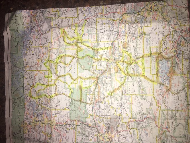
Just back from annual NW Arkansas trip and even after ten years I still rely on the marked up maps. We have so many variations of twisty rides depending on time or weather and winging it sometimes causes :fight

DA0475A4-2647-4EFC-B201-63FA23F32EAE.jpeg

A typical two week markup :laugh
That and the road numbering system in AR can befuddle the new visitor... and the regulars at times too! Your GPS will tell you you’re on 10 when no signage indicates it. 10 runs same route as 16, 27, and so on in places. :eek

On cross country or some state runs, having a large picture and backing away allows me to find alternate routes that flow well and look interesting or direct when needed. I can glance down mid ride and pick a town off the “ plan” and reroute if food or fuel is that-a-way. MsGarmin can’t make that call unless I really ask nicely. Bi-focal sunglasses as mentioned also have prolonged on the fly choices. My GPS tells me where I am, the map seriously expands the view without losing detail.

As mentioned Quebec wanted money for one, a few eastern states are not printing them anymore and direct you to their online maps... grrr. We stopped at TX Welcome Center the other day and I typically get two new maps... the clerk said How about three? I accepted.
 
Last edited:
Back
Top