• Welcome, Guest! We hope you enjoy the excellent technical knowledge, event information and discussions that the BMW MOA forum provides. Some forum content will be hidden from you if you remain logged out. If you want to view all content, please click the 'Log in' button above and enter your BMW MOA username and password.

    If you are not an MOA member, why not take the time to join the club, so you can enjoy posting on the forum, the BMW Owners News magazine, and all of the discounts and benefits the BMW MOA offers?

  • Beginning April 1st, and running through April 30th, there is a new 2024 BMW MOA Election discussion area within The Club section of the forum. Within this forum area is also a sticky post that provides the ground rules for participating in the Election forum area. Also, the candidates statements are provided. Please read before joining the conversation, because the rules are very specific to maintain civility.

    The Election forum is here: Election Forum

2021 MOA Rally Picture Thread

We're kind of a luddite crew and we don't use GPS (I was a cartographer so I prefer paper) so I'm sorry to say we don't have any tracks. However, if you're looking to take a ferry to Great Falls and you're travelling on US Highway 2 turn south at Chinook, MT: https://goo.gl/maps/rMKmerV23CmrEhHy6

There is no gas between Chinook and Winifred and the roads are impassible if wet.

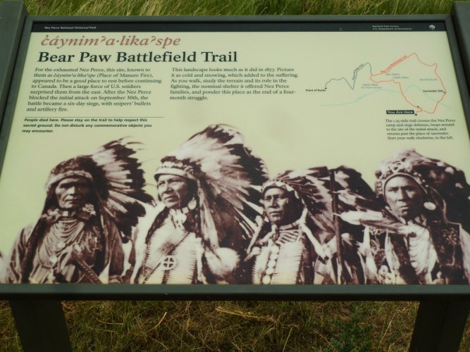
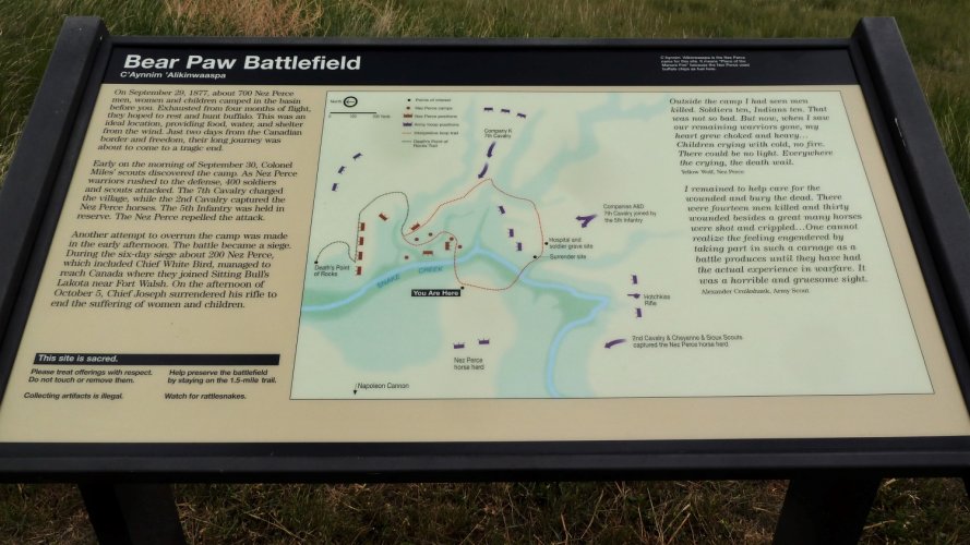
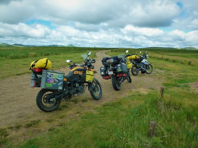
The first image is a few miles south looking at the Bears Paw Mountains in northcentral Montana. The second image was taken a few miles north of the Stafford Ferry (the Missouri Breaks).

Thanks for info Richard !!


Sent from my iPhone using Tapatalk
 
On this route, 16 miles south of Chinook is the Bear Paw Battlefield, Nez Perce National Historic Site. This is the location where Chief Joseph and a band of Nez Perce, attempting to flee to Canada, surrendered to the U.S. Army. In what is considered one of the most memorable speeches ever, Chief Joseph has been translated to have said:

"I am tired of fighting. Our chiefs are killed. Looking Glass is dead. Tu-hul-hul-sote is dead. The old men are all dead. It is the young men who say yes or no. He who led the young men [Ollokot] is dead. It is cold and we have no blankets. The little children are freezing to death. My people, some of them, have run away to the hills, and have no blankets, no food; no one knows where they are – perhaps freezing to death. I want to have time to look for my children and see how many of them I can find. Maybe I shall find them among the dead. Hear me, my chiefs. I am tired; my heart is sick and sad. From where the sun now stands I will fight no more forever."

If you are riding across U.S. 2 this is a worthwhile short side trip. We discovered it on a test ride after I replaced the deformed axle tube and rebuilt the rear hub on Voni's F800S in a motel parking lot in Chinook in 2011.


Good history lesson Mr Glaves!
All the above (well... not the axle rebuild) would have been in October 1877, about 12 years after the US Civil War.
And for perspective may I include two related events of irony.

In June of 1805, a mere 72 years before the Bear Paw surrender... at a point 40 miles SW (near Loma MT on Hy 87, about 50mi NE of Great Falls);
Meriwether Lewis (the Lewis & Clark Expedition) and party spent 9 days at the confluence of the Marias and Missouri River...
pretty much deciding which way to go. They even named the camp Decision Point.
They chose correctly, but were plenty befuddled in their exploration of that area.
And makes me wonder how different history would have been, had they set off up the Marias River toward the Continental Divide
and the Glacier region.

And secondly; just about two years later and about 125 mile west of Bear Paw. Near Cut Bank MT.
On the return trip of the L & C Expedition, Meriwether had the only hostile encounter with Indians.
Over stolen property he stabbed one and shot one.

Just imagine that in one man's lifetime, the exploration to determine the boundaries of our Nation, the Civil War and the Indian Wars.

Incredible.

5/19/21 Addition: Something had been picking at my mind a few days. I finally remembered!
No, it wasn't the Pony Express or the Telegraph era across the American west.
But it's closely related, and it also meant doom for the Indians' way of life.
It was construction of the Transcontinental Railroad.
There was a contentious period just 10 years before the Bear Paw siege and surrender, specifically along the route through Nebraska and
Wyoming. The rail line split the buffalo herds, as they would not cross the tracks. Skirmish and raids were pretty frequent across the plains.
Weaponry made a significant change to the proceedings beginning summer of 1867, US Army soldiers began receiving the Springfield rifle.
It was a breechloader sighted for a thousand yards maximum range.
On two occasions in fall of that year, the Sioux lost some of their best warriors to the quickness and range of the new Springfield.

From about 1850, as a young hunter and brave, through his passing in 1904...
Chief Joseph certainly had perspective on western expansion.
 
Last edited:
A stop at the Battlefield

On this route, 16 miles south of Chinook is the Bear Paw Battlefield, Nez Perce National Historic Site. This is the location where Chief Joseph and a band of Nez Perce, attempting to flee to Canada, surrendered to the U.S. Army. In what is considered one of the most memorable speeches ever, Chief Joseph has been translated to have said:

"I am tired of fighting. Our chiefs are killed. Looking Glass is dead. Tu-hul-hul-sote is dead. The old men are all dead. It is the young men who say yes or no. He who led the young men [Ollokot] is dead. It is cold and we have no blankets. The little children are freezing to death. My people, some of them, have run away to the hills, and have no blankets, no food; no one knows where they are – perhaps freezing to death. I want to have time to look for my children and see how many of them I can find. Maybe I shall find them among the dead. Hear me, my chiefs. I am tired; my heart is sick and sad. From where the sun now stands I will fight no more forever."

If you are riding across U.S. 2 this is a worthwhile short side trip. We discovered it on a test ride after I replaced the deformed axle tube and rebuilt the rear hub on Voni's F800S in a motel parking lot in Chinook in 2011.

Informative Signs at the Battlefield
 

Attachments

  • Battlefield 1.JPG
    Battlefield 1.JPG
    822.1 KB · Views: 390
  • Battlefield 2.JPG
    Battlefield 2.JPG
    902 KB · Views: 389
  • Battlefield Stop.JPG
    Battlefield Stop.JPG
    433.5 KB · Views: 390
Good history lesson Mr Glaves!
All the above (well... not the axle rebuild) would have been in October 1877, about 12 years after the US Civil War.
And for perspective may I include two related events of irony.

In June of 1805, a mere 72 years before the Bear Paw surrender... at a point 40 miles SW (near Loma MT on Hy 87, about 50mi NE of Great Falls);
Meriwether Lewis (the Lewis & Clark Expedition) and party spent 9 days at the confluence of the Marias and Missouri River...
pretty much deciding which way to go. They even named the camp Decision Point.
They chose correctly, but were plenty befuddled in their exploration of that area.
And makes me wonder how different history would have been, had they set off up the Marias River toward the Continental Divide
and the Glacier region.

And secondly; just about two years later and about 125 mile west of Bear Paw. Near Cut Bank MT.
On the return trip of the L & C Expedition, Meriwether had the only hostile encounter with Indians.
Over stolen property he stabbed one and shot one.

Just imagine that in one man's lifetime, the exploration to determine the boundaries of our Nation, the Civil War and the Indian Wars.

Incredible.

.... 5/19/21 Addition: Something had been picking at my mind a few days. I finally remembered!
No, it wasn't the Pony Express or the Telegraph era across the American west.
But it's closely related, and it also meant doom for the Indians' way of life.
It was construction of the Transcontinental Railroad.
There was a contentious period just 10 years before the Bear Paw siege and surrender, specifically along the route through Nebraska and
Wyoming. The rail line split the buffalo herds, as they would not cross the tracks. Skirmish and raids were pretty frequent across the plains.
Weaponry made a significant change to the proceedings beginning summer of 1867, US Army soldiers began receiving the Springfield rifle.
It was a breechloader sighted for a thousand yards maximum range.
On two occasions in fall of that year, the Sioux lost some of their best warriors to the quickness and range of the new Springfield.

From about 1850, as a young hunter and brave, at Bear Paw in 1877, and through his passing in 1904....
Chief Joseph certainly had perspective on western expansion.

...the 5/19/21 addition noted above.
 
We left the truck this morning and set out in the sidecar at a spirited pace. Glenlivet approved of being in his ride again far from home. Currently in Conifer CO. Tomorrow we start the journey to the California coast and (eventually) the rally

DDD073AF-F30D-48C6-832E-385EAA7885F6.jpeg
 
We spent a couple days on the NorCal and southern Oregon coast, with the second day a loss due to rain. Hard to appreciate Scenic Viewpoints when the lighthouses are hidden by the rain. The sun came out for five minutes in Bandon OR, long enough for me to spread some of Barley's ashes on his favorite beach.

DSCN1991_BandonOR.jpeg

We escaped the rain on US-20 to Sisters, then 126/26/7 across the state. Today we played in Hells Canyon and pretty much had it to ourselves. What a magical place!

DSCN2006.jpeg

Tomorrow Lolo Pass. We hope to camp along the Selway River.

Pete and Glenlivet
 
Snowy Range, South East WY

41FC00D6-CE20-4035-8022-9323A7DEF844.jpg

Great elevation changes with some tight curves. Summit is 10,200 ASL. Best of all, almost no traffic. From Laramie take WY 130 west. On the west side go to Saratoga for the hot springs on the bank of the North Platte river. Watch out for the Pronghorns, on the prairie, and the moose in the mountains.
 
Headed west!! I have thread going on here if anyone interested…

https://advrider.com/f/threads/ride-to-montana-2021-bmw-moa-rally-from-massachusetts.1507091/

6202b3f0e00b446697bc188ebd1912ba.jpg


Indiana

e22a8a13f3c4670f095cc2b2756a3808.jpg


Somewhere in Iowa.


Sent from my iPhone using Tapatalk
 
View attachment 84102

Great elevation changes with some tight curves. Summit is 10,200 ASL. Best of all, almost no traffic. From Laramie take WY 130 west. On the west side go to Saratoga for the hot springs on the bank of the North Platte river. Watch out for the Pronghorns, on the prairie, and the moose in the mountains.

We really liked that road last September and also checked out the hot springs.
It was our first time on that road. We had planned to take hwy 14 in Colorado but it was closed due to the fire.
We lucked out with our detour choice.
 
Well the girl working there said it was sold to panhandle couple years ago. She’s a local who’s family owns 2 ranches in the area. That’s all I know. I was there in 2015 and it was That Spot then. Thankfully it’s like I remember it but no inside tables
 
Not so rough rider!

To make matters worse, there is a HONDA in the trailer.

We are camped in a beautiful state park, where the #MOAposse riders would have met…. It’s perfect for an overnighter.

B5E7EEF7-3583-48D5-B0DA-81E19D2F5552.jpg
 
Last edited:
Back
Top