• Welcome, Guest! We hope you enjoy the excellent technical knowledge, event information and discussions that the BMW MOA forum provides. Some forum content will be hidden from you if you remain logged out. If you want to view all content, please click the 'Log in' button above and enter your BMW MOA username and password.

    If you are not an MOA member, why not take the time to join the club, so you can enjoy posting on the forum, the BMW Owners News magazine, and all of the discounts and benefits the BMW MOA offers?

  • Beginning April 1st, and running through April 30th, there is a new 2024 BMW MOA Election discussion area within The Club section of the forum. Within this forum area is also a sticky post that provides the ground rules for participating in the Election forum area. Also, the candidates statements are provided. Please read before joining the conversation, because the rules are very specific to maintain civility.

    The Election forum is here: Election Forum

Colorado in August 2009

well, not counting the necessary evil of the eastern plains, of course.
and hold your nose closed if you come thru Kersey area on US34- the feedlots can be pretty brutal.

The old joke was..

A guy was on a date with his gal, and out parking, and she said..."oh honey, please kiss me where it stinks!!"

So he drives her to Greeley!
 
2nd 141 Along The Delores River

Pretty much any two lane highway west of I-25 will yield good riding, but a loop not to be missed if you have the time is Colo. 141, you catch it about 10 miles south of Grand Junction on Highway 50, then take Colo 145 out of Naturita to Cortez. From there, east on US Hwy 160 to Durango, then north out of Durango on US Hwy 550 to Montrose. This is probably one of the best loops in Colorado, and 141/145 are not heavily travelled or patrolled and are just made for motorcycles. I'm salivating just sitting here writing about it in January (sob). You can do this loop in a day, it's about 390 miles starting and ending in Grand Junction. 2 days would allow you to savor it more. And, if you do go to Grand Junction, don't miss Colorado National Monument.

I would highly recommend this ride also. :)
 
okay- what's your favorite mexican food places in FtC and Loveland? I know the Rio does the best margs, but who's got the best rellenos and el pastor? i like Taquerio Rancho Allegre 3 over on 14th St. near the old H-P plant.
 
Although Mexican food for me is/was a staple in my life, it's been 6 years since I fed this south of the border habit it Fort Fun..

The Rio was my favorite in atmosphere and has the best Tacos el Carbon, my favorite rellenos and other Mexican especials has to go to the place off highway 14 and Link Lane, North of The Hunt strip club...forgot the name... Castillions?

Taquerio Rancho Allegre 3 was not there, but I will go next summer when I'm riding out there in the fall...

Been awhile...

Greeley in all it's glory used to have several holes in the wall Mexican Places that were great! El Charro on 9th street was real mex and delicious! Not hot like tex mex, but real authentic flavor...

I used to hate El Burrito off Pine Street and Linden, but ended up eating there alot because I worked abut four blocks away...
 
if you like Castillion's you'll love Rancho Allegre. we had our local BMW club- the Twisted Shaft- meetings at Castillion's for awhile. nothing special was my estimation.
when you heading out here? we'll have to do some riding! and eating :)
 
Cottonwood Pass from Buena Vista to Taylor Park is a great ride, dirt road and not a huge amount of traffic. From Taylor Park you can go north to the Aspen area via jeep roads.

.

Warning about the Taylor Pass Rd... This is what you will find to get up to the pass then down the easy side to Aspen...

gslimit.jpg
 
i'd sure rather tackle that going uphill than down! that kind of large scrabble doesn't give much for braking traction. or most any other kind of traction you might be looking for.
 
Warning about the Taylor Pass Rd... This is what you will find to get up to the pass then down the easy side to Aspen...

gslimit.jpg

:bow 
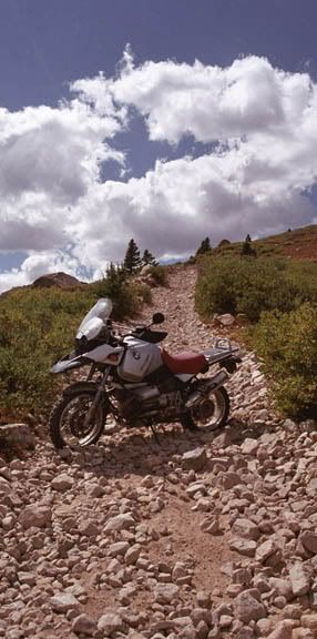
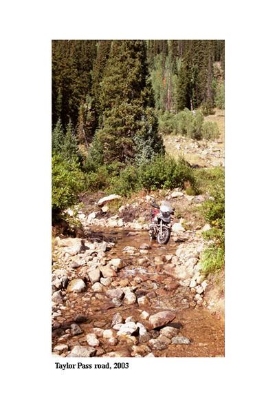
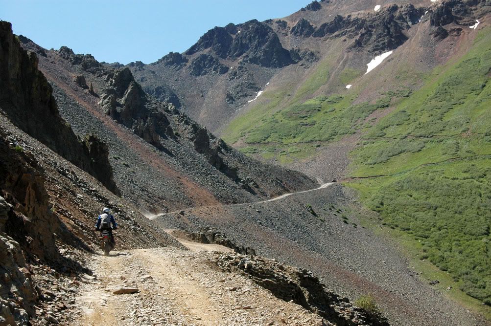
I have hiked this a time or two, and would have no problem on my 250, but for this trail, my 12 GS "Pig" will never asked to go..


I remember several other areas rutted out and full of ponds that could be quite a go.

I did, however get quite a few miles above Marble a couple of years ago, to a camp above the trees! That's as far as she goes!

Again, my hats off to you!
 
i'd sure rather tackle that going uphill than down! that kind of large scrabble doesn't give much for braking traction. or most any other kind of traction you might be looking for.

going up must be just as tough!

probably the best way to ride this going down would be to put the bike in first, turn the motor off, and use the clutch to control forward motion. using the front brake for anything more than basic control would be a recipe for a face plant.

:bow mike - what do you recommend.

ian
 
easy does it

going up must be just as tough!

probably the best way to ride this going down would be to put the bike in first, turn the motor off, and use the clutch to control forward motion. using the front brake for anything more than basic control would be a recipe for a face plant.

:bow mike - what do you recommend.

ian

The closest "event" to ending in motorcycle death by free slide off a cliff was on this kind of stuff..my family coined the word "Marble Patch".

When you try to slow down, you slide, and when you slide, you have no directional control, so once the speed of your bike is set by the leash of low gear, keep rolling!
 
i'd sure rather tackle that going uphill than down! that kind of large scrabble doesn't give much for braking traction. or most any other kind of traction you might be looking for.

redclfco said:
The closest "event" to ending in motorcycle death by free slide off a cliff was on this kind of stuff..my family coined the word "Marble Patch".

When you try to slow down, you slide, and when you slide, you have no directional control, so once the speed of your bike is set by the leash of low gear, keep rolling!

Actually i was trying to get up this stuff.... this was the first summer i had the silver GS after comming back from Australia... to say the least... this was a bit over my skills for off road riding... i had been down a few nasty sections already with others like Scholfield (which is off limits except for expert riders) and HandCock passes but i went down the other section of road to have lunch at the lake and could not make it up the other section since it was too steep with and turn around a tree to get up... so i went up the main section of road... rule... NEVER LISTEN TO AN ATVer from Texas... just above about 50 yds from the picture the road turned to just dirt... i was doing about 30-35mph and hit the big rock just below the rear tire (picture) at this point i was 4/5 of the way up this section of this 'Marble Patch'... and spun out and went down... not a scratch on the bike.. i had a sprained left hand from going over the the handle bars into a bush... my Rally Pro 1 jacket did its job and not even a mark since i landed boulder in the bush.:hungover :hungover .. i tried to get the bike going again up hill even walking/running it.. no go... then it took me about 20 minutes to get the bike pointed down hill when i took the picture... with a stiff left hand i had to ride out to Taylor Park and then to Almont (south of Crested Butte) for fuel... i went 272 miles on the tank that day..:whistle :eek

but to get out i had to go through a section where the road and river are one... at least it was August and we had a good drought that year normally the water is about knee deep..
TP2.jpg

and a few boulder fields...

YEs on a 600 or less i would have no problem... even know with my much more imporved riding skills i could most likely do it now... but i first need to ride other roads...
 
going up must be just as tough!

probably the best way to ride this going down would be to put the bike in first, turn the motor off, and use the clutch to control forward motion. using the front brake for anything more than basic control would be a recipe for a face plant.

:bow mike - what do you recommend.

ian

Dirt roads or Dirt Pass Roads.

Level Easy/Beginner... somthing a Jagurar could do in most contitions... normally a bit of coregation in the switch back and curves..

Cottonwood (west side... eas side is paved)
Crooked pass (Eagle to Frying Pan river via to Basalt, Dry only has section of Bentonite on the south side which is a mess in the wet)
Yellow Jacket Pass (East of Meeker, South of Craig)
Kebler and Ohio Passes (west of Crested Butte) warning on Kebler.. the cars
drive a bit too fast since it is a nice dirt road
Muddy/Buzzard Pass/Divide (From 6 miles west of McClure Pass CO133 to Colburn, CO)
Owl Creek Pass (west of Ridgeway, SSW of Gunnision)
Wanitia, Black Sage, and Old Monarch Passes (do them as one ride) (South of Pitkin {East of Gunnision ending just above Monarch Ski area})
West Cottonwood (Carbondale to Gypsum) one section is bentonite alone a climb that is fine to go down (from Gypsum in dry contirions and is okay to come up with okay tires)
Stunner Pass ( South of South Fork on the way to Cumbres and La Magna Passes)
Marshal Pass (just take right about half way up Poncha Pass leaving from Poncha Sprgs heading south)
Shrine Pass (at Vail Pass)
Old Cochatoe Pass (SSE of Gunnision)
Los Pinas Pass (south of Gunnision)
Gunellia Pass (out of Georgetown

Intermediate (I can do these on Metz Tourance tires but most would want knobbies since there are sectoins that might be tricky or loose or imbedded roack sections... in a rough order to how i rate them from easier intermediate to the harder intermediate)

Cumberland Pass (south of Taylor Park/ town of Tin Cup) it was some larger
gravel-ly on the surface but not issuse to 4 wheels but for us on
on 2
Ptarmagain Pass (west side only) (Above camp Hale, north of Leadville)
Webster Pass (North Side on the town of Montezuma)
Jones Pass (access at bottom of Berthod Pass
Scholfield Pass (South Side only!!! sharp switch backs and paridise valley road is narrow with great views but very steep drop offs)
Weston Pass (only on section on west side is a bit steep and looser dirt... can get messy if it has been rain a lot without not much traffic on it east side is a dirt highway
Hagerman Pass (Basalt to Leadville) Some imbedded rocks on the top with looser sections on east with lot of cross road water erosions 'speed dips' west side from the upper section has some imbedded road with loose rocks to technical manuvering in one section)
Ophir Pass (heading west only west side) West side has this easier to go down then up trust me on this
OUOphirriding4.jpg

Gateway to Castle Valley, UT road... if wet it is a muddy mess of sludge
Rollins Pass (I have only done the East Side up to where the FS closed the road the last 1/4 mile to the Needles tunnel)
Georgia Pass (north side... can be quite rough)

Advance/Expert ( only listing them... you need to contact me on conditions and issues

Webster Pass (South side is not nice into Handcock (??name) Gultch)
Mosquito Pass (east of Leadville 13285ft up)
Ptarmagain Pass (East/North side) (very narrow through the forest on the top half.. then into a box canyon where you play hopscotch with the creek that
has some deep at time sections of creek)
Scholfield Pass (Punch bowl section west side)
Black Bear Pass (personally dont do it it is not nice to say the least if do able with out major cycle damage on a large bike)
Imogene Pass (dont know much ... it is nasty in a lot of section... did it in a jeep long time ago)
Cinnimon Pass
Engineer Pass
Ophir Pass (heading East from town of Ophir)
Lead King Basin Road (above Marble... do this going down it... would be nasty to get up the main valley section of the skree field you drive up at the hair pin turn)
Taylor Pass (South Side is a tough... North side is Intermediate)
Many more i have not done
 
Last edited:
Ian- i would not recommend using no engine for downhill. if you need power, you just don't have it in a controllable form. if you don't need it.. well, that's what the clutch does for ya.

we found out a bit late that Schofield
gettingreadytotackleSchofield.jpg

was not navigable by our "GS" bikes. (3 R1100Ss and one R1200ST)
DeeChrisdirt-biking.jpg

fortunately, the only damage was a flat tire via a candy corn sized rock.
theSchofieldrockandplug.jpg

we made it about 7 miles up- apparently, just before things get tricky.
 
Ian- i would not recommend using no engine for downhill. if you need power, you just don't have it in a controllable form. if you don't need it.. well, that's what the clutch does for ya.

we found out a bit late that Schofield

we made it about 7 miles up- apparently, just before things get tricky.

I would tell people dont even think about Scholfield pass.... its rough side (Marble side) is a very terechous and very technical even for jeeps with lift kits

http://www.code4x4.com/articles/schofield_jeep/schofield-jeep-trip.html

one with a video of jeeps going up
http://www.atvtrails.org/Schofield_Pass.html

the problem with Scholfield Pass is going up is rough for anything even small cycles... a GS would be very difficult... plus the line normally for a cycle is a on the outside on the edge.
http://www.flickr.com/photos/dok1/66278691/ a picture of the river you have to drive through normally cylindar deep water even at the end of the summer..
cars have to stop and dry there brakes before heading down.
more picts
http://www.ghosttowns.com/states/co/schofield.html

http://www.mycolorado.org/images/schofield/images/IMG_3157.jpg
http://www.mycolorado.org/images/sch...s/IMG_3178.jpg

Good pict from ADVrider on Scholfield
81230260-L.jpg

I went a few miles above Crystal, and decided to turn around and find a place back down to camp by the stream. I did not want to go higher and bust my chops way up there by my self late into the evening....

See that little wild stream?

Those rapids hold sweet little brook trout!

I'm glad I stopped! Plus Marble is still as delightful as the first time I explored it at the age of 4!

July07BMW017.jpg
 
I went a few miles above Crystal, and decided to turn around and find a place back down to camp by the stream. I did not want to go higher and bust my chops way up there by my self late into the evening....

[/IMG]

How did you like with road tires getting up to the fork in the road above Crystal town site where to the left to LeadKing and to the right Scholfield... I have gone into Crystal with Metz tourance but with spoked rims... a bit gutzy to go in on mag rims and not worry about cracking a rim...:thumb
 
How did you like with road tires getting up to the fork in the road above Crystal town site where to the left to LeadKing and to the right Scholfield... I have gone into Crystal with Metz tourance but with spoked rims... a bit gutzy to go in on mag rims and not worry about cracking a rim...:thumb

Thats exactly why I turned around! What I went up, I had to go down!
The road just got worse and worse, plus I alomost got ko'd by a jeep; once stopped, I was lucky to get going again!
 
Back
Top