• Welcome, Guest! We hope you enjoy the excellent technical knowledge, event information and discussions that the BMW MOA forum provides. Some forum content will be hidden from you if you remain logged out. If you want to view all content, please click the 'Log in' button above and enter your BMW MOA username and password.

    If you are not an MOA member, why not take the time to join the club, so you can enjoy posting on the forum, the BMW Owners News magazine, and all of the discounts and benefits the BMW MOA offers?

  • Beginning April 1st, and running through April 30th, there is a new 2024 BMW MOA Election discussion area within The Club section of the forum. Within this forum area is also a sticky post that provides the ground rules for participating in the Election forum area. Also, the candidates statements are provided. Please read before joining the conversation, because the rules are very specific to maintain civility.

    The Election forum is here: Election Forum

Blue Ridge Parkway

RTRandy

New member
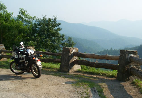
After hearing how great Deals Gap, Cherohala Skyway, and Blue Ridge Parkway are, I'm going to try and include these on my way to Nova Scotia.

If I were to pick up the Blue Ridge Parkway say around Asheville, NC for example and take it all the way north to Front Royal, VA, can anyone tell me how long of a trip I should expect? Any suggestions welcome as to where stop for dining or lodging would be a help as well.

Obviously this won't be interstate speed plus I would plan on lots of traffic and hopefully riding this during the week.
 
Start farther south near Mount Vernon / Tellico Plains, TN.

I guess about two days from there to Front Royal, VA. at a leisure pace. Which is the best way to enjoy the moment.

Doc

EDIT: Tellico Plains, TN to Roanoke, VA (halfway) to Front Royal, VA = 641 miles @ 17 hours (Mapquest)

Cherohala Skyway - BRP - Skyline Drive :thumb
 
Last edited:
SFDOC said:
Start farther south near Mount Vernon / Tellico Plains, TN.

I guess about two days from there to Front Royal, VA. at a leisure pace. Which is the best way to enjoy the moment.

Doc

EDIT: Tellico Plains, TN to Roanoke, VA (halfway) to Front Royal, VA = 641 miles @ 17 hours (Mapquest)

Cherohala Skyway - BRP - Skyline Drive :thumb

Thanks Doc.

I'm allowing a day from Tellico Plains to Robbinsville and then Robbinsville to Maryville which will cover the Cheroala Skyway run and Deals Gap run in a day. It's up in the air how I'll get to Asheville from Maryville, but I could cut through the park on 441 or just come across on I-40. Have no idea how 441 is ,but don't want it to be another Yellowstone in July. I realize it cuts off some of the Blue Ridge Parkway from Ravensville to Ashville, but I want to have the days to ride Nova Scotia and New Brunswick.

I'm just trying to figure out the time riding Blue Ridge from Ashville to Front Royal. Mapquest plots it taking I-26 and I-81 to Front Royal for 400 miles and 6.5 hours on the interstate the whole way. I'm thinking it might be more like 10 hours?
 
Well, then I think you should go from Maryville to Peyton on I-81 then (R) on I-64 to Waynesboro and get on Skyline Drive. By-pass the BRP for speed, you will have much of the same scenery without the 35 and 45 mph speed limit. BRP is nice if that is the only stretch your doing, but if you see the southen and the northern ends, the middle only gets you there. :dunno

Note to self: Do what you just said in life, (I only did the BRP from Boone to Cruso Road Intersection) Still look forward to the day to go where you are going.

K12Coop - where are you on this one. He's the local guy out that way.

Doc
 
RTRandy said:
I'm just trying to figure out the time riding Blue Ridge from Ashville to Front Royal.

Depends on what you want from the ride. I've taken 3 days to do this ride with frequent stops to look at the scenic views, hike some of the trails (e.g. Linville Falls - BRP milemarker 318), and visit some nearby attractions.

In pleasant weather I have enjoyed making the ride from Fancy Gap (BRP mm 198) to Ashville and a bit beyond (BRP mm 385 to 415) and then on to the Georgia Mountain Rally in one day. Fallen trees or other reasons frequently seem to keep the part south of Ashville closed.

One year I was headed towards the GMR and decided to spend the night somewhere between Christiansburg and Roanoke, Virginia so I could ride more of the BRP the next day. Well I did make it to the GMR that next night, but I decided that I had too much of the BRP for one day's ride. I didn't get to see much more than the yellow line in the road (no time to stop and take in the scenery) and when I got to the GMR it was nearly dark - no fun setting up the tent and the Friday night chilli was all gone :-(

In poor weather (i.e., rain and fog) the ride from Ashville to the Virginia / NC border is MUCH less fun. My speeds seem to be closer to 20 mph rather than the 45 mph limit.

Early morning and dusk on the BRP bring out the deer - it isn't a question of if you'll see them, but rather how many and can you avoid hitting one.

So if you can spend only a day and the weather is ok ride at a comfortable pace, spend the night somewhere in Virginia, then jump on the Super and motor on up north. If you have several days and wish to see the sights, then go at a more leisurely pace and enjoy yourself.

In the off season (early May) I have enjoyed staying in Blowing Rock (exit near BRP mm 290). I've also stayed and eaten at the hotel / restaurant (Lee's ?) behind the NorthWest Trading Post (BRP mm 257) and at the Peaks of Otter (BRP mm 85). Best to call for a reservation at the Peaks of Otter - they have no television in the rooms (a big plus!!).

http://www.nps.gov/blri/
http://www.blueridgeparkway.info/
http://freespace.virgin.net/john.cletheroe/usa_can/scenroad/brp.htm

The Skyline Drive is actually a separate park which does charge an admission fee (and has a lower speed limit).

http://www.nps.gov/shen/
http://members.aol.com/adnascar/driving.html
 
Last edited:
Do 441 then pick up the BRP at the begining. The best part of the BRP (most technical) is from the Southend to Doughton (sp) Park. It turns into sweepers and nice undilations after that. You would miss the highest point on the Parkway,Mt Mitchel, Pisgah,and all the tunnels by picking it up North of Linville Falls.A Nice day from Tellico is Cherihola,The Gap,Foothills Parkway then pick up 441 to the start of the BRP then about three to four hours to Little Switzerland for the night aroun mile 335.Next day BRP either to the end or maybe stop Peaks of Otter Lodge on the Parkway in Bedford VA around mile 95.After leaving the BRP Skyline Drive feels slow 35posted vs 45 and Skyline Dr. is heavily enforced.During non Holiday weekdays the ride is much less traveled. Have Fun and smell the wildflowers
 
BRP bottom to top

SFDOC said:
K12Coop - where are you on this one. He's the local guy out that way.Doc

You can ride the BRP in one day but you will not enjoy doing it that way. You do want to ride both of the ends however and the middle is pretty cool too. I am not sure if the detour up close to Mt Mitchel is open or not yet.

My favorite part of the BRP is the section from the South end to the Pisgah Inn. It is also a great place to stay and have a meal. Make sure you have fuel or you will be walking as there is not service on that end of the parkway.

I would allow a day and a half and stop some where in the middle like close to "Meadows of Dan". Not sure of the mile marker on that but there is a good motorcycle only camp ground there i believe called Willville. You will probally find a pack of beemers there as it is well known in the beemer crowd.

I have ran a touring company in that neck of the woods for motorcycles so if you have any additional detailed questions send me a PM and I will be glad to help you out any way i can

Koop
 
It all depends

It all depends

Like someone else said it all depends on what you want to do. Ride the BWP 2 days Experience the BWP 3 days. Here is my input to BWP planning.

Pick up a copy of the BWP guide at the first ranger station you cross. The guide lists gas food and other things by the mile markers. Plus it is free.

Fog until 9:30 am and rain showers after 3:30 pm. Pack lunch if you can so you donÔÇÖt waste a lot of your prime riding hours looking for grub.

Park ranger near the major cities.
 
Not sure of the mile marker on that but there is a good motorcycle only camp ground there i believe called Willville. You will probally find a pack of beemers there as it is well known in the beemer crowd.

Willville is at BRP mile marker 177, just a mile down Rt 58. Clean showers, laundry, evening campfire and more, two thumbs up! There's also a small motel there on Rt 58 if you're not into camping.
I find one actually can make good time on the BRP. You can easily average 50 mph, there's not a stop sign on the entire length. Subtracting for whatever stops you choose of course.
 
I made a copy of all the above replies and showed it to a member of our DFW club while at coffee this morning and he was blown away at the wealth of good information received here. I appreciate all the good advise from those who've traveled these roads. Thanks !!

I 'm going to come across lower Tennessee on Hwy 64 and make it over to Tellico plains. I'll ride Cherohala Skyway, Deals Gap and cut through Great Smokey Nat Park on 441 and to begin the BRP. I'll take the BRP to Asheville and then get on I-81 north by way of I-26. From I-81 I'll get back on the BRP either at Roanoke or at Waynesboro depending on time and weather. I just don't think I'll have the time to ride the entire BRP this trip, but at least I can get a good run on hopefully the best parts.

I love the link to the Cycleresort in Tellico and made a note of the early morning fog, deer at dawn and dusk, rain in the afternoon, lack of gas, cops out to enforce the speed limit and the don't ride on weekend part.

I'm planning on taking my time on these roads just enjoy the ride and hopefully make stops to take photos which I'll post when I return. I'll be marking my maps with all the above lodging and dining suggestions so thanks again. This forum rules!! :D
 
:wow I envy you RTRandy, have fun, I know you will...

Keep the Sticky side down and your eyes on the Horizen :wave

We're waiting for you to get back home and post a Ride Report. :lurk
 
BRP's awesome, I haven't quite gotten down THAT far on it (but then again, it's high on the list for this spring :=) ) but the top end is basically in my front yard(4 mi.)... I've had a lot of fun coming home on it from I-64 access after my eye apointments in Richmond... not only watch out for deer, though, but watch out for bear! Great when you see em, but it sure is freaky when you've only got a riding suit between you and it hehehehe. That being said, they'll leave you alone if all ya do is look :)
 
RTRandy said:
I'm just trying to figure out the time riding Blue Ridge from Ashville to Front Royal. Mapquest plots it taking I-26 and I-81 to Front Royal for 400 miles and 6.5 hours on the interstate the whole way. I'm thinking it might be more like 10 hours?

That sounds about right... assuming fairly steady riding at ~50mph. Bring warm gear... it's significantly cooler on the mountains than it is down lower.

If you're getting on in Asheville, see if you can find NC151... it's near I-40 east of Asheville. It will make for a far more entertaining entry to the BRP than getting on in the middle of town.

Another nice place to start your ride is the Blue Ridge Motorcycle Campground which is southeast of Waynesville on US276 and just a nice twisty ride away from the parkway.

Ian

Ian
 
RTRandy said:
I 'm going to come across lower Tennessee on Hwy 64 and make it over to Tellico plains. I'll ride Cherohala Skyway, Deals Gap and cut through Great Smokey Nat Park on 441 and to begin the BRP. I'll take the BRP to Asheville and then get on I-81 north by way of I-26.

Whoops, missed this post.

Check the BRP before you go down 441... it was still closed yesterday where it crosses Balsam Gap (US74)

Another very fine way to get to I-26 from Deal's Gap is to take NC28 south from the south end of the Dragon, to US74 east, to NC209 to Hot Springs. From Hot Springs, US25/70 South/East to NC208 then NC212 to I-26. Sweet roads.

r80gs.jpg


Ian
 
Visian said:
Check the BRP before you go down 441... it was still closed yesterday where it crosses Balsam Gap (US74)

Another very fine way to get to I-26 from Deal's Gap is to take NC28 south from the south end of the Dragon, to US74 east, to NC209 to Hot Springs. From Hot Springs, US25/70 South/East to NC208 then NC212 to I-26. Sweet roads.
Ian
Thanks SFDOC and Belg for the support and info. If I see a bear, it's going to turn into a photo session for sure.

Ian, I highlighted the map using 74, 209, and 212 to 23. That looks good, but it cuts out the south end of BRP. I was told that section of the BRP from the park to Asheville is a must ride. Then again, that whole area looks good so I'm sure you can't go wrong. 212 actually cuts into what looks like Hwy 23 even though it aligns with I-26 to the south and at Erwin there looks to be a scenic road 81 which is parallel to 181 at Johnson City and it also cuts over to 81. Have you tried that 81?

I think the price to pay for riding these special roads is I'm going to have to trade with a lot of Big Slab to get me up to Nova Scotia. I'm coming further east than originally planned to ride the Smokey Mountains which I want to do if I'm going to be that close, but there's just so many days of vacation.

It's looking like I-81 after riding to Front Royal all the way to Scranton or Bimington,NY before cutting over towards Albany and Troy. From there it should be some good roads again. Who knows, I-81 could be nice through PA.

I've been spoiled the last two summers riding out west. Huge highways with zero traffic and and making great distance in a day not to mention dry weather. I think there's no way you can make that kind of time riding in the northeast with all the dense population and traffic. We'll see. There's always the ride home as well.

Thanks again.
 
RTRandy said:
Ian, I highlighted the map using 74, 209, and 212 to 23. That looks good, but it cuts out the south end of BRP. I was told that section of the BRP from the park to Asheville is a must ride. Then again, that whole area looks good so I'm sure you can't go wrong. 212 actually cuts into what looks like Hwy 23 even though it aligns with I-26 to the south and at Erwin there looks to be a scenic road 81 which is parallel to 181 at Johnson City and it also cuts over to 81. Have you tried that 81?

It's ok, nothing to write home about. BTW, US23 is now I-26. The nicer roads to get to I-81 and the long slog north (right decision on your part, BTW) are on the east side of I-26. TN91 goes east through a series of valleys and goes through Damascus, VA to intersect with I-81. That's a nice ride.

You're right about the southern end of the BRP... it's the highest elevation section of the parkway and a grand ride. If you're near the Mt. Pisgah Inn/rest area around breakfast or lunch (north of where US276 crosses) I recommend stopping in.

This section of the parkway is often in the clouds, btw, even when the weather is not-so-bad down low. So if the weather ain't so good, consider the roads I've shown you.

Ian
 
I-81 Binghamton to Albany

Hi,

We hit I-81 south of Binghamton last year and there was constant construction/traffic backed up, so maybe have a few detours in mind that you can quickly exit and then hop back on further up the line :dunno

Binghamton on to Oneonta is nice, but Oneonta to Albany is really rather pretty - or you can run Rt 7 which runs along side 81 or if you want other routes like 23 to 10 or 23 to 30, they still shoot you up towards Albany.

If you find yourself near Cobleskill/Schoharie - let me know, you're welcome to stop in if you need a break :wave
 
Hey De,

Thanks for the offer. I've got you noted for when I know I'll be nearby.

What's the deal on 7 winding around I-88 ? I didn't see it until I zoomed way in. Can you make good time on it ?

Any tricks to getting around Albany to the east side so I can take 7 to Bennington, VT ?

Randy
 
Oooppps

I meant to state I-88, use to travel I-81 all the time from Syracuse to Whitney Pt. sometimes to Binghamton - got them confused, sorry.

From Binghamton you would take 88 towards Sidney, Oneonta, Worcester, Cobleskill if you want to slab it. Otherwise Rt 7 runs along with 88 through little towns. On Rt 7 I average 60-65, but do obey speed zones through the little towns, once outside of them you can go.

As for getting around Albany over to Troy/Rt 7 - it's not that bad depending on time of day and there are two ways.

Have to get back to work, will touch base with you later on it - De
 
Back
Top