Navigation
Install the app
How to install the app on iOS
Follow along with the video below to see how to install our site as a web app on your home screen.
Note: This feature may not be available in some browsers.
More options
-
Welcome, Guest! We hope you enjoy the excellent technical knowledge, event information and discussions that the BMW MOA forum provides. Some forum content will be hidden from you if you remain logged out. If you want to view all content, please click the 'Log in' button above and enter your BMW MOA username and password. If you are not an MOA member, why not take the time to join the club, so you can enjoy posting on the forum, the BMW Owners News magazine, and all of the discounts and benefits the BMW MOA offers?
-
Beginning April 1st, and running through April 30th, there is a new 2024 BMW MOA Election discussion area within The Club section of the forum. Within this forum area is also a sticky post that provides the ground rules for participating in the Election forum area. Also, the candidates statements are provided. Please read before joining the conversation, because the rules are very specific to maintain civility.
The Election forum is here: Election Forum
You are using an out of date browser. It may not display this or other websites correctly.
You should upgrade or use an alternative browser.
You should upgrade or use an alternative browser.
Would love some Oregon Washington road suggestions
- Thread starter RTRandy
- Start date
Hey Dave, Great information as always coming from you.
I've marked some of your favorites in my GPS map with a special note to try and make that turn off into Mt St Helens if the weather is good. That road is NF99 which comes off of NF25. My GPS will have me continuing down to Carson and not getting fooled to get on to NF90 which runs along the Swift Reservoir. Actually looks interesting along the water heading over to Cougar and Yale lake.
Also noted is that straight road 221 from Lake Umatilla in Paterson to Prosser. It's always amazing to arrive at these roads or places after only looking at just a line on a map. Not sure what I'll see, but planning to ride it.
Route 2 looks interesting if I can make it up that far. I've ridden Route 12 (Lolo Pass) to Missoula a couple of times, but never west of Lewiston. I just need to somehow connect these routes together.
The more I learn about this area other than all the rain, I wouldn't mind living there.
Thanks!!
14RT_rider
14_R1200RT
Northern WA ride
Hwy 20 at the northern part of Washington is a fantastic scenic ride. Also central Oregon anywhere in the cascades.
Hwy 20 at the northern part of Washington is a fantastic scenic ride. Also central Oregon anywhere in the cascades.
If you're heading westbound into SE Washington (say Lewiston-Dayton-Walla
Walla) you end up on the Oregon side of the Columbia. You can cross north at Umatilla, and continue west on WA 14. That "straight" road isn't as straight as it looks on the map, and it dumps you into the Yakima Valley. (wine country)
Yes, you could head Northwest to Yakima, then 12 west (White Pass) and on to Randle and FS 25 South. But if you haven't seen Mt. Rainier, I would suggest turning to the north on 123 for a couple of miles, and riding through Rainier National Park, then turning south at Elbe on 7 to Morton, east on 12 to Randle, and south on FS 25.
http://www.bing.com/images/search?q=mt+rainier&FORM=IGRE&qpvt=mt+rainier#
Note that the Washington (north) side of the Columbia is more scenic, while I-84 is the superslab. However, in the Columbia Gorge between Hood River and Gresham, there is the old scenic highway up on the side of the cliff above the superslab. Narrow and twisty (as in Model T) but a dozen or so waterfalls, including the famous Multnomah Falls.
http://www.fs.fed.us/r6/columbia/millennium2/welcome.htm
Highway 2 is a good alternative to I-90, between Spokane and Ellensburg. Getting through W Spokane is a bit of a PITA, but once your through you're in wheatfields and lava rock. If you take this route, don't miss Grand Coulee Dam, not only an impressive block of concrete, but beautiful lava cliffs on the way.
From Coulee Dam, you can either head west on 174 via Bridgeport, Brewster, Pateros, and 153 to Twisp, picking up 20 to Winthrop, and west over the spectacular North Cascades highway. (be sure to gas up before heading uphill)
Or, from Coulee Dam, you can head southwest on 155 to Coulee City, and west on 2 to Wenatchee. At the west end of the Dryfalls Dam, be sure to take the side trip just a couple of miles south on 17 to Dry Falls.
http://www.experiencewa.com/attraction.aspx?id=178
From Wenatchee, you can go west on 2 via Leavenworth (pseudo-Bavarian mountain town) and over Stevens Pass to the Everett area, or hang a left onto 97, south to Ellensburg, and the Yakima Canyon (Avoid the superslab I-82) to Yakima. And, from Yakima ("yak-im-ah") you can head west over White Pass (remember?) or south on 97 to Goldendale and Maryhill, and south over the bridge to Oregon.
http://www.legendsofamerica.com/WA-Stonehenge.html
pmdave
O
oregonsage
Guest
Not 101
It is being implied, but not said that Hwy 101 itself through Oregon is not the greatest route, especially the northern half. During the summer it is often a motorhome/sightseeing parade on the highway and several of the towns are bumper to bumper for miles. I would get off of 101 and head inland at Reedsport, then just past Drain head north via Lorane to Veneta to Cheshire to Philomath to Dallas and then take your choice of roads through wine country and the NE corner towards Astoria to cross into WA. 101 in WA seems to be a much more pleasant experience IMHO.
http://maps.google.com/maps?f=d&sou...123.338013&sspn=0.948869,1.766052&ie=UTF8&z=9
Something like this.
Hey LonniJ, Welcome to the forum and thanks for the great info. That was actually going to be my next question. 101 looks like a great road running along the coast, but if it has tons of traffic, it's probably not worth the effort. Right now it's looking like coming in from the Reno area and taking Hwy 36 due west to Ferndale on the coast. It's the portion going north in question.
I just took a stab on the map and chose 101 all the way north from Ferndale,CA taking me past Coos Bay and then heading inland at Florence on Hwy 126.
I'm wondering if it's the same issue in northern California. Would I be better off cutting up into Oregon on 199 through the Redwood forest into Grants pass?
I don't mind riding along the ocean in traffic averaging 25mph. The issue is I've got limited days on this vacation trip and riding a hundred miles in four hours can kill a day.
PMDAVE
Great info! I've marked all the routes and thanks to you I'm planning to get a picture of Monmouth Falls, Dry Falls, and the Grand Coulee Dam. I'm also going to try not to miss out on a ride through Mt Rainier since I'll be so close. These are all places I would have missed without the help of the forum community. I plan to post a view of my final route on a map when finished with the planning.
Great stuff. Thanks !!
F
franze
Guest
entering CA
Hi Randy,
If you are flexible on where you enter CA and are running north from Vegas area, I suggest NV 266 off 95,. It becomes CA 168 and will take you into CA just north of Death Valley and into Big Pine. 395 N will take you along the east side of the Sierras. I rode this (Lido Pass) last summer on my way home from Monument Valley as it is supposed to be a good place to see wild mustangs. I didn't see any but the riding was fabulous. There's nothing out there, no towns, no factories, no traffic, no service and no gas
If you do come through Reno, make sure you include Virginia City on your route. This is the town made famous during the beginning of Bonanza when the map started burning. A great town, last time I was there two cowboys were getting their horses re-shoed on Main Street .
Paul
It's not so much that 101 (and 1) up the coast isn't worth the visit, it's that the trip along the coast is so spectacular that it draws lots of tourists in the summer.
But, you can pick and choose some sections, and take some in, and not fight the motorhomes all the way. I'll offer my opinions, and let the locals disagree.
California: Between Morro Bay and Monterey: 1 twists and turns along the coast, very scenic and unforgettable. 101 between San Luis Obispo and Salinas is forgettable.
Between Monterrey and San Francisco: 1 is scenic, but more industrial. 101 is heavy traffic and sluburbia. My advice: find 9 from from just east of Santa Cruz (1) north into the skyline , then 35 north, 92 west to 1, and 1 north all the way to the Golden Gate bridge. 1 north of SF is pretty, but the south end is a bit busy. I'd suggest 101 to Greenbrae, then turn off toward San Anselmo, and toward the coast and Pt. Reys Station. These are the roads the Sunday bikers have their fun with the cops. Or, make a transit to Asti, then get your twisty kicks on 128, cutting back to 101 at Leggett.
IMHO, 101 north from SF all the way to Willits is like any other urban/suburban superslab. Multi lanes, heavy traffic, not much to look at. From Leggett north, you get into the Redwood forests, and traffic thins out.
If you're coming from the east, 20 around Clear Lake is not bad. Just lots of slow villages.
Eureka is worth a visit, especially the old town and it's mansions. If you happen to be in Eureka at dinner time, take the ride out onto the spit and have dinner at the Samoa Cookhouse (call and make sure they are still in business and open)
http://gocalifornia.about.com/od/cacoast/California_Coast.htm
If you've had your fill of twisty coastal roads by the time you approach the Oregon border, you can head northeast towards Grants Pass, and take the I-5 superslab north. Lots of hills make this more interesting, and you'll make good time.
But if you still have a hankering for more coast, the central Oregon coast is very scenic. If you stop at only every third spectacular beach or overlook, you could easily spend two days riding 101 to Astoria. My favorite section is between Florence and Lincoln City. There are maybe 50 beaches and viewpoints, and not a bad one in the bunch. Much better than the southern section past Coose Bay/North Bend--unless you like logging trucks and lumber mills.
When I'm heading from Lincoln City north, I usually take 18 via McMinnville. Remember, that's the location of Howard Hughes' Spruce Goose. But the ride between Lincoln City and Astoria is not bad--some great sections of cliffs high over the Pacific Ocean. And of course, you MUST stop at the Tillamook Cheese Factory. (well, OK, and ice creamery)
http://www.traveloregon.com/Explore-Oregon/Oregon-Coast.aspx
The Washington Coast calls, too, but if you need to beat your feet, you can hang a right at Tillamook or Mohler, and follow the back roads (say 103, 202, 47) and cross the Columbia River to Longview--and I-5.
If it's boiling hot, note that you can cool down by heading either to the coast, or uphill. For instance, if it's hot in Reno, just head over the passes on 89/70 up in them gold-laced hills. From Chico you can take either 70 or 32, and go through Lassen Park, then 44 and 89 back toward I-5. And if it's hot in Medford, head uphill toward Crater Lake.
I haven't touched on the high Sierra passes, national parks, etc. It's hard to go wrong in that country. The most interesting motorcycle ride is the old Gold Rush road, now highway 49. You'll swear there's a bike ahead you can't catch--until you realize it's your own tail light.
http://california-travel.suite101.com/article.cfm/discover_californias_gold_country_on_hwy_49
pmdave
SeabeckS
New member
As always, Mr Hough gives VERY good route advice...the only thing I might add is that the Evergreen Air & Space Museum in McMinnville has much more than just the Spruce Goose for aircraft aficianados. One of the best air museums in the country IMHO and well worth a few hours of appreciation if you're in the neighborhood.
And the California routing is perfecto mundo, when we lived in Nevada I spent a lot of time on Hwy 1 and environs with riders in my family. Also, I MUCH prefer that route into Oregon from Crescent City to Grant's Pass. Not nearly as much traffic as the Coast Highway...
I'm starting to turn green with envy over your trip plans!
Cheers, Bill J
Okay. I'm trying to use all this great advice so now rethinking my entrance into California thanks to you Californians. Let's back up a ways so you can see the route logic and hopefully I can fine tune what I have so far.
The point of this is to ride up 395 which I've never ridden. Let's start at Torrey, UT which is along the way. From Torrey going to hit Ceder City on 36 to 375 to Tonopah.
I'm choosing this since riding further south to Las Vegas and taking 168 north of Death Valley looks like taking too much time away.
So here's the question: Route 6 from Tonopah hits 120 at Benton, NV. Shortly after there is a road called Benton Crossing going past a Lake Crowley south of Mommoth Lake or you can continue on 120 which comes into 395 just south of Lee Vining.
Any one way better than the other ?
Oh and one other question: When I get up near Lake Tahoe should I cut over on 207 to the south part to ride up the east side , or continue up to Carson and cut over on Hwy 50? I'm sure it's slow going along the lake, but looks good on the map.
And PM Dave, thanks for the suggestions in Eureka. Looks like I'll spending the night there as well.
SeabeckS
New member
Okay. I'm trying to use all this great advice so now rethinking my entrance into California thanks to you Californians. Let's back up a ways so you can see the route logic and hopefully I can fine tune what I have so far.
The point of this is to ride up 395 which I've never ridden. Let's start at Torrey, UT which is along the way. From Torrey going to hit Ceder City on 36 to 375 to Tonopah.
I'm choosing this since riding further south to Las Vegas and taking 168 north of Death Valley looks like taking too much time away.
So here's the question: Route 6 from Tonopah hits 120 at Benton, NV. Shortly after there is a road called Benton Crossing going past a Lake Crowley south of Mommoth Lake or you can continue on 120 which comes into 395 just south of Lee Vining.
Any one way better than the other ?
Oh and one other question: When I get up near Lake Tahoe should I cut over on 207 to the south part to ride up the east side , or continue up to Carson and cut over on Hwy 50? I'm sure it's slow going along the lake, but looks good on the map.
And PM Dave, thanks for the suggestions in Eureka. Looks like I'll spending the night there as well.
Randy,
I'd suggest 120 as the better route, as my memory serves (danger Will Robinson!) the roads through Benton Crossing are MOSTLY not paved. And you would only miss a few miles of 395 by taking the more direct route to Lee Vining.
I'd also highly recommend 207 into the Tahoe Basin. It's a much nicer ride than HWY 50. If you can spare the time a really excellent detour route is to take CA 89 west from 395 just south of Topaz lake and the Nevada border, go through Markleeville to Woodfords, and hang a right on CA88. This takes you into Nevada, and just a couple miles south of Minden (my prior residence for 15 years) you find the junction of 207. FYI, that route CA88 is ranked number ONE in N. Calif. motorcycle roads in the Destination Highways book.
At Tahoe, 207 intersects US 50 just a bit north of the Casino area at the south end of the lake. Turning north you can either follow 50 back to Carson City, or take NV28 to Incline Village, then 431 over the top of Mt Rose summit and back to 395 just south of Reno. As someone else recommended, a trip through Virginia City can be fun, to do this I'd just go down through Carson and take US 50 west. The road from Carson to VC isn't that much fun, but if you take the alternate "Truck Route" near Silver City there will be a little less traffic. After leaving VC headed towards Reno, the road called Geiger Grade is a bit nicer piece of pavement, with a couple of nice overlooks as you drop down the hill towards the Truckee Meadows and Reno.
Can't recommend highly enough CA89/88 thru Markleeville, not a lot of traffic, and some nice bendy road too. If you're looking for a different sort of dining experience, try one of the Basque style family dinner places in Gardnerville (The J-T, or the Overland). And if you go to one of these places, and like a interesting sort of pre-dinner cocktail, ask for a Picon Punch...you may be pleasantly surprised. If you don't stop in Gardnerville, but perhaps spend a night in Reno, try Louie's Basque Corner on 4th Street a couple of blocks east of Virginia St. (the main drag). (MMMmmm, my mouth is watering just thinkin' about it! LOL)
One other thing I'd mention, traveling across that Cedar City/Tonopah/Lee Vining stretch....don't pass up too many gas stations...they are few and FAR between!
You're gonna have a great time!
Cheers! Bill
(Feel free to PM if you'd like more feedback)
OfficerImpersonator
Seattle-area Rounder
Ride on volcanoes!
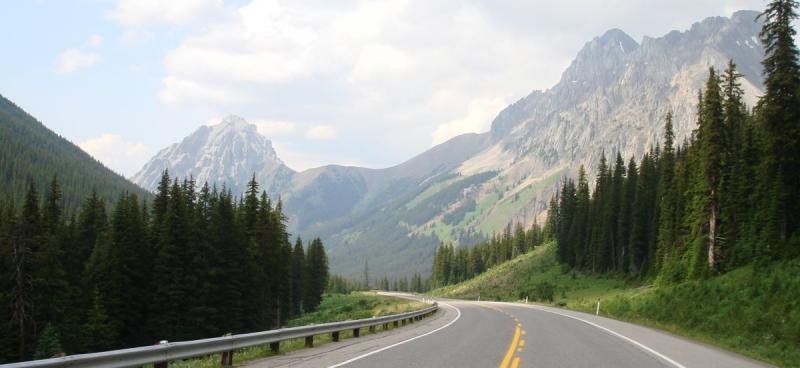
When in Washington State, you cannot not ride U.S. Forest Service Road 25 between Randle and Cougar and U.S. Forest Service Road 99 which leaves FS 25 for Windy Ridge on Mt. St. Helens.
You'll be riding on and around three Cascade Volcanoes - Mt. Rainier, Mt. Adams, and Mt. St. Helens. The roads are virtually un-patrolled by law enforcement. And they roads are CURVY!!!
There are myriad ways to incorporate FS 25 and FS 99 in to larger rides as they all eventually connect to I-5, I-90, I-84, U.S. 12 and other major roadways via other spectacular routes.
The top section of my web page on riding details the trip I did last summer with a couple of friends. http://www.dvandkq.net/Motorrad.htm
Zoom in on the highway in the center of the map (also listed as State Route 131) to see for yourself the location and the nature of the roads in this area: http://maps.google.com/maps?f=q&source=s_q&hl=en&geocode=&q=randle,+wa&sll=37.0625,-95.677068&sspn=51.576045,114.169922&ie=UTF8&hq=&hnear=Randle,+Washington&ll=46.274834,-121.970215&spn=0.710016,1.783905&z=10
SeabeckS
New member
+1 (heck, make that +10!) to what O.I. says here. Only caveat is to make sure and check with USFS current road info. You can get very committed to the route before suddenly finding a "ROAD CLOSED AHEAD" sign. The detour can be quite long...........
Don't ask me how I know that...okay? LOL
But seriously nice territory back in them thar hills.
Cheers! Bill J
Don't ask me how I know that...okay? LOL
But seriously nice territory back in them thar hills.
Cheers! Bill J
When in Washington State, you cannot not ride U.S. Forest Service Road 25 between Randle and Cougar and U.S. Forest Service Road 99 which leaves FS 25 for Windy Ridge on Mt. St. Helens.
+1 (heck, make that +10!) to what O.I. says here. Only caveat is to make sure and check with USFS current road info. You can get very committed to the route before suddenly finding a "ROAD CLOSED AHEAD" sign. The detour can be quite long...........
Cheers! Bill J
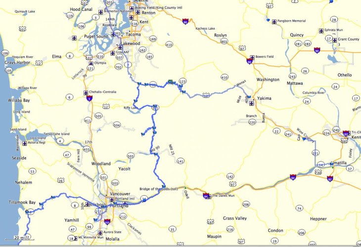
It's locked and loaded in my GPS and in my mind for sure after PMDave suggested how great these were. Good to know about the possible closings though not sure why they'd be closed during the first part of July. I'll check for sure before we head down them. Great stuff! Thanks to all the help here on the forum the route is taking shape leading me to places I would have never known to ride. It's looking like departing Dallas on the first of July so my good riding friend can join me. How cool is that!
Attachments
Randy,
I'd suggest 120 as the better route, as my memory serves (danger Will Robinson!) the roads through Benton Crossing are MOSTLY not paved. And you would only miss a few miles of 395 by taking the more direct route to Lee Vining.
I'd also highly recommend 207 into the Tahoe Basin. It's a much nicer ride than HWY 50. If you can spare the time a really excellent detour route is to take CA 89 west from 395 just south of Topaz lake and the Nevada border, go through Markleeville to Woodfords, and hang a right on CA88. This takes you into Nevada, and just a couple miles south of Minden (my prior residence for 15 years) you find the junction of 207. FYI, that route CA88 is ranked number ONE in N. Calif. motorcycle roads in the Destination Highways book.
Cheers! Bill
(Feel free to PM if you'd like more feedback)
I changed the route based on your good information to take 120 near Benton Crossing as well as cutting over on 89 to take 88 before getting on 207 on the east side of Tahoe. From there it's looking like heading up the west side of Lake Tahoe and taking 89 all the way up to 36 just south of Lassen. I've ridden through Lassen a few years ago and loved it, however I want to get to all the new places so skipping it this trip. I'll take 36 all the way to the coast. Thanks!
SeabeckS
New member
If your not doing the trip over Lassen have you considered any of the other passes to get into the upper Sacramento Valley? Hwy 70 Feather River route is nice but can get really trafficed up....with a lot CHP's around as well.
I've made multiple trips over all the Sierra passes, and my personal fave is Yuba Pass. Road intersects CA89 at Sattley, about 20 north of Truckee and goes through Downieville leading to Nevada City. I'd have to get out a map and study it, but also used to cut off the last few mile of that route to avoid Nevada City, some nice quiet two lane roads can take you to Oroville, which is about an hour south of CA36 at Red Bluff. CA49 thru D-ville is VERY nice piece of pavement, and at least in the old days, wasn't as heavily RV'd as some of the other Sierra splendiferous roads....
I'm just sayin'...(Or just insane?)
As an aside...my most memorable ride was doing all the Sierra passes in the course of a few days. Riding my Duc 900SS/SP, and accompanied by my b-in-law on his VFR, we started near Red Bluff, went up to Lassen then crisscrossed our way south to Yosemite. Had perfect weather the whole time...and wonder of wonders had zero encounters with the black and whites. Sigh....
Cheers, Bill J
SeabeckS
New member
Just noticed on the GPS map route you've posted that you'll be passing by my neck of the woods near Bremerton. If you're at all interested in local brew pubs I can't say enough good words about Silver City brewhouse in Silverdale, just off Hwy 3. They've won much recognition in national industry competition, and have a very good selection of excellent food dishes on their menu.
If you're passing through around lunch or dinner (or in between!) it's highly recommended! Personally I don't drink and ride, but a short beer with some delicious food seems acceptable most days.
Ciao! Bill J
If you're passing through around lunch or dinner (or in between!) it's highly recommended! Personally I don't drink and ride, but a short beer with some delicious food seems acceptable most days.
Ciao! Bill J
Hey Randy:
Don't forget about doing a little side trip through your favourite Kananaskis Country, on your way back!
I don't know Rinty, last time I took your route advice I ended up on some pretty plain ol roads.

Attachments
OfficerImpersonator
Seattle-area Rounder
+1 (heck, make that +10!) to what O.I. says here. Only caveat is to make sure and check with USFS current road info. You can get very committed to the route before suddenly finding a "ROAD CLOSED AHEAD" sign. The detour can be quite long...........
Don't ask me how I know that...okay? LOL
But seriously nice territory back in them thar hills.
Cheers! Bill J
I wonder if your "closed road" situation had anything to do with the "new bridge" we encountered on FS 25 when we did the trip at the end of last summer
")
Similar threads
- Replies
- 5
- Views
- 888