• Welcome, Guest! We hope you enjoy the excellent technical knowledge, event information and discussions that the BMW MOA forum provides. Some forum content will be hidden from you if you remain logged out. If you want to view all content, please click the 'Log in' button above and enter your BMW MOA username and password.

    If you are not an MOA member, why not take the time to join the club, so you can enjoy posting on the forum, the BMW Owners News magazine, and all of the discounts and benefits the BMW MOA offers?

  • Beginning April 1st, and running through April 30th, there is a new 2024 BMW MOA Election discussion area within The Club section of the forum. Within this forum area is also a sticky post that provides the ground rules for participating in the Election forum area. Also, the candidates statements are provided. Please read before joining the conversation, because the rules are very specific to maintain civility.

    The Election forum is here: Election Forum
+++++++++++++++++++++++++++Great Dual sport riding in the UP

625850921_2PciE-XL.jpg


Hurleyis is tame today, 1920s and 1930s when Hurley was one of the most notorious places in the country.

taken from Wisconsin Historical Society:
"tucked away up in the wild lumber and iron section of northern Wisconsin, right on the Michigan State line, has the distinction of being the worst community in the State. Conditions in Hurley are not unlike those of settlements like Dawson City, Cripple Creek, El Dorado, Borger, and other boom communities. Gambling, prostitution, bootlegging, and dope are about the chief occupations of the place. Saloons there function with barmaids who serve the dual capacity of soda dispenser and prostitute."

has nearly 30 bars, a rather unusual number for a town of 2,000.


This area offers you hundreds of miles of dirt trails


626501771_THCXP-XL.jpg


626502030_k4xhX-XL.jpg
 
Last edited:
++++++++++++++++++++Plummer Mine Headframe - Pence, WI

798372628_RX9iQ-XL.jpg


Plummer Mine shaft
Opened in 1904
angles downward from the headframe following a vein of ore into the earth
to a depth of 2,367 feet.

The Plummer Mine closed in 1924
the last such headframe standing in Wisconsin.

From an engine house, cables ran up over the wheels at the top of the headframe
and were attached to elevator cars, lowering miners and equipment underground
and pulling ore cars back to the surface.

State Road 77
Pence, WI​

798373194_gZWy5-XL.jpg


626502626_7LmFe-X3.jpg
 
+++++++++++++++++++++++++Gogebic Range

626502814_dtNiH-X3.jpg


This is the mud hole
that Rustoleum Paint
gets all of its Iron Oxide Primer :laugh


Of the six principal iron ranges in the United States,
three are located primarily in Michigan

the Marquette Range, all of which is found within the state,
the Menominee and Gogebic ranges which are located in both Michigan and Wisconsin.

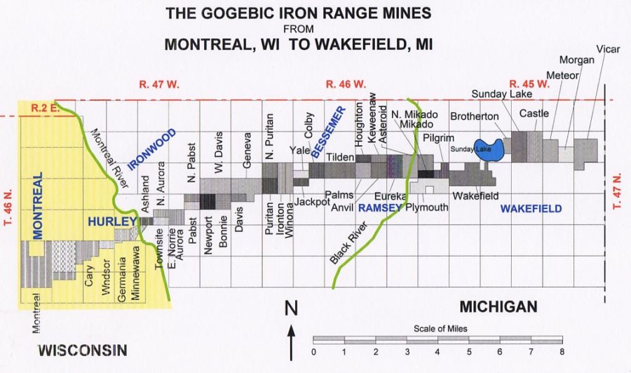
The Gogebic Range lies partly in Michigan and partly in Wisconsin divided by the Montreal River

This range extends almost 80 miles between Atkins Lake in Wisconsin and slightly west of Lake Gogebic in Michigan; the Michigan section is approximately 30 miles long


The Gogebic Range

a trapper and hunter, who seen red ore outcropping from the roots of an overturned tree near Bessemer in 1879. By 1884, this ore location, known as the Colby Mine, began to produce commercial iron ore.

In 1882, iron was discovered near Wakefield, the discovery became the famous Sunday Lake Mine. During that same year Norrie Mine in the city of Ironwood started.

Soon the Railroad had begun a line that was run from Milwaukee into Michigan new mining district during the summer of 1884

By 1910, three separate railway lines served the Gogebic Range, and approximately four million tons of iron ore were being shipped annually.

The range became the frenzied "Gold Rush" speculation during the late 1880s, and the total capitalization for the companies formed in the year 1886 reached a total of over one billion dollars.

production rose steadily from 1884, reaching a high water mark in 1892

From 1893 through the first decade of the twentieth century, production levels ranged from approximately 3-4 million tons of ore shipped,


mapmines_900x532.jpg
 
Last edited:
+++++++++++++++++++++++++++Montreal, WI - one of Wisconsin Company Towns

626504871_bVcYe-X3.jpg


Montreal, WI - one of Wisconsin Company Towns

Above:
The impressive Machine Shop
with one of the Montreal Company Houses in the background

132 white-painted company homes
consist of four different models of kit-built bungalows with porches


Originally, miners settled around the Montreal mining shaft
constructed homes on land leased from the Company
1918, in order to retain workers
the company rented pre-fabricated homes to miners

When the Montreal Mines closed in 1963, 600 workers lost their jobs
Many went to the American Motors plant in Kenosha
Homes were sold for $2,500 to $3,500

Montreal Mine - the world's deepest iron mine (4,337 feet)

Montreal looks more like a New England village today than a former mine site

The Montreal Company Historic District
was added to the National Register of Historic Places in 1980
as a national example of industrial community planning.

Below:
Montreal's 105 year old Sacred Heart Church


626502227_pFuev-X3.jpg
 
I really like your photos and comments. Wisconsin is a great place to visit. I have ridden to your wonderful state but have not seen as much as I would like. I will make a return trip!
JD
 
++Gogebic County, Michigan++Upper Peninsula Heritage Trail System

ironwood___the_gogebic_range.gif


625846618_HCggm-XL.jpg


Saxon Harbor
located on Lake Superior's Oronto Bay in Iron County, Wisconsin,

Historically, this was near the beginning of an ancient Native American trade route known as the Flambeau Trail

was the site of a fur trading post operated by John Jacob Astor's American Fur Company from 1808 to 1830​


626504954_iXJi4-X3.jpg


On the Ironhorse Trail

Siemens Railroad Bridge (1896)
bridgehunter.com/mi/
This bridge is a good example of a Baltimore through truss

one of the many remaining historic artifacts in this area
that tell of a time when iron brought prosperity
and extensive railroad activity to this rather remote region of the country


Ironhorse Trail runs along Michigan Highway 2 (map below)
westup.gif


www.hunts-upguide.com


626505226_UVCbU-XL.jpg


Gogebic County Courthouse
The courthouse was constructed in 1888
upheritage.org
 
Last edited:
+++++++++++++++++++++++Ramsay KEYSTONE BRIDGE

626506250_SPjAx-XL.jpg


HISTORY OF THE KEYSTONE BRIDGE
The Keystone Bridge was constructed in 1891 by Chicago and Northwest Railroad at a cost of $48,322.

Similar to old Roman architecture, the bridge was built without mortar on a solid rock foundation.

The bridge consists of a series of arches, with each arch having a center keystone at the top to lock in the entire structure.

The 5 foot thick blocks used to construct the bridge are limestone, which was brought from Kaukauna, Wisconsin.

The bridge is 45 feet long, 44 feet wide, 57 feet high, with 50 foot walls. This

Historic Keystone Bridge
bridge carried mining and logging materials across the Black River.

Although millions of tons of freight shipped by rail passed over the arch bridge, the bridge is structurally sound.

The bridge is a stop along the
Upper Michigan Heritage Trail Network


626506102_gpXyD-XL.jpg


626506543_v86ES-X3.jpg


The Ramsay Bridge (bridge in the background)
is an impressive example of a concrete girder bridge
To a bridge lover, the bridge in the background is as significant as the Keystone Bridge
Go figure:dunno

 
Last edited:
...........Birnamwood, Wisconsin

732200179_bF4Ye-XL.jpg


Birnamwood, Wisconsin

World's Largest Badger
A giant badger head and claws -- part of a once-larger statue

Was at one time part of a gift shop . . .


732199014_wA7Qu-XL.jpg


. . . now emerge from the ground as greeters for a club


732199373_S69WU-XL.jpg


......................... Cadott - halfway point between the equator and North Pole

LND5380-XL.jpg


halfway point between the Equator and North Pole
(why does the pole seem so very much closer most of the winter?)


:)
 
>>>>>>>>>>>>>>>>>>>>>>> Cornell, Wisconsin - 20 miles north of Chippewa Falls

LND5392-XL.jpg


175-foot-long Pulpwood Stacker
located in Cornell, Wisconsin

Looks like a tipped over oil rig

the only remaining apparatus of its type in the US
was designed in England,
manufactured in Minneapolis,
used in Cornell from 1913 until 1972
& unused since 1972


LND5388-XL.jpg


IMG8139-XL.jpg


IMG8143-XL.jpg
 
Just north of Chipewa Falls Wisconsin - The Cobban Bridge


LND5402-XL.jpg


The Cobban Bridge
constructed in 1908
486-foot span
by the Modern Steel Structural Company of Waukesha, WI
a two-span Pennsylvania overhead truss type bridge
oldest of its kind in Wisconsin
Originally it crossed the Chippewa River
just upstream from its junction with the Yellow River
The bridge was dismantled during the construction of the Wissota Dam in 1916

Between 1916 and 1918,
the Wisconsin-Minnesota Power & Light Company
built a hydroelectric dam four miles downstream from the bridge,
putting the site under water


During the winters of 1916 and 1917
the disassembled bridge was hauled here by horse and sled
with the movers receiving one dollar per ton for the fifteen mile trip


LND5396-X3.jpg


Just north of Chippy Falls - Old Abe - Jim Falls, Wisconsin


LND5425-X3.jpg


"Old Abe"
http:wikipedia.org/Old_Abe
the famous eagle mascot of the 8th Wisconsin Infantry
Taken from its nest when only four months old
the eagle had been purchased and presented to the regiment
then preparing to go to the front
"Old Abe" was given a place next to the regiment flag
where he remained for the next three years.

The eagle died in 1881 and was stuffed and mounted for public display

I couldn't make that up :dunno


>>>>>>>>>>>>>>>>>>>>>>>>Chippewa Falls, Wisconsin


IMG8158-XL.jpg


St. Charles Borromeo Church
perched atop Stanley Hill

1884-85
First unit of St. Charles was built.

The three beautiful Altars of the newly erected Church
were a gift of Jacob Leinenkugel


:thumb

Also on Stanley Hill

The original McDonell High School
is now
Heyde Center for the Arts

30,000 sq. ft. structure constructed in 1907,
is a Neo-Classical Architectural Design
is listed on both the National and State Register of Historic Places.

Sitting on a hilltop overlooking the city of Chippewa Falls
within view of the grand Chippewa River,


IMG8167-XL.jpg


The view from Stanley Hill
overlooking Chippewa Falls
(population 14,000)

IMG8164-XL.jpg


>>>>>>>>>>>>>>>>>>>>>>>>Chippewa Falls, Wisconsin


Cook-Rutledge Mansion


IMG8269-XL.jpg


Listed on the National Register of Historic Places
beautifully restored Victorian-era home
of lumber baron Edward Rutledge

one of the finest remaining examples of
High Victorian Italianate architecture in Wisconsin

 
~~~~~~~~~~~~~~~~~~~~~~Irvine Park & Zoo Chippewa Falls, Wisconsin


IMG8250-X3.jpg


Beautiful Glen Loch Dam
@ 318-acre
Irvine Park & Zoo
Chippewa Falls, Wisconsin


LND5509-XL.jpg


IMG8223-X3.jpg


IMG8226-XL.jpg


Irvine Park & Zoo :brow
Chippewa Falls, Wisconsin


LND5441-X3.jpg


~~~~~~~~~~~~~~~~~~~~~~~~~~Chippewa Falls - IRVINE PARK

LND5516-XL.jpg


Rumble Bridge
named for the rumble of the tires on the wooden planks

Lost truss bridge over Duncan Creek

near century old (1914)
Rumble bridge was use to span a large ravine
to get from south end of the Irvine Park to the north end of Irvine Park

Not use for vehicle traffic anymore


LND5522-X3.jpg
 
~~~~~~~~~~~~~~~~~~~~~~~~~~Chippewa Falls - IRVINE PARK

LND5455-XL.jpg


The Sunny Valley School House
built in 1903
used from January 1904 until 1964.


Ole and Mari Bjerke Cabin
is over 100 years old


LND5462-XL.jpg
 
Back
Top